The 13 Best Hikes in Yosemite Valley
This article originally appeared on Outside
Outside my window in Mariposa, California, in the Sierra foothills, I can see that the leaves have turned. Yosemite National Park and the surrounding mountains are an incredible year-round destination, with dustings of snow in winter and plenty of river access to cool off during hot summers. Spring and autumn are practically perfect for hiking. Winter is a quiet and peaceful time to be on the trails, too.
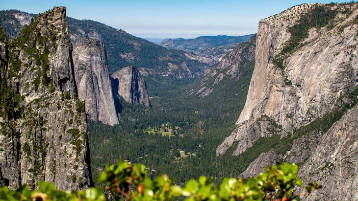
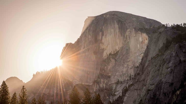
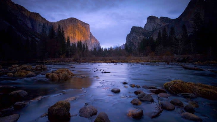
The valley offers some of the greatest vistas in North America, or even the world, with the verdant Merced River dotted by meadows and encircled by massive walls--up to Middle Cathedral at 1,700 feet, Half Dome at 2,500, and El Capitan at over 3,000--and a huge variety of hiking trails to see views of them.
The area was once known as the Ahwahnee Valley, and the original inhabitants were the Ahwahneechee. By the late 1700s, most of Yosemite was inhabited by the Miwok, and in the 1800s, Paiute and others. Their lives changed in the mid-1800s with the Gold Rush, and many were killed or displaced. In the 1900s, most dispersed.
In 1890, the area was designated as the country's third national park. Today, 4.5 million tourists visit annually from around the world. Most, however, don't make it more than a mile down many trails, so if you go out a ways it feels like you have the place to yourself. Or yourself and some others: you'll likely see ravens, Stellar's jays, and if you're lucky, coyotes and black bears.
Trails and walks in the park may be short and feasible for people of all ages, or they may climb thousands of vertical feet, offering incredible views of changing plants and trees. From the Valley floor to its rim, trees transition from black oaks, incense cedars, and Douglas firs to Jeffrey pines, with their longer needles and larger pine cones. Sugar pine trees at higher elevations grow cones so enormous that they're visible from a distance, over a foot long and weighing down the branches. Granite slabs reflect the sunlight, and Half Dome, isolated at the far end of the valley, commands the view.
My favorite time to hike in Yosemite is during the peak of winter, January and February, when no one else is around. Tree branches hang down due to heavy snow, the long sweep of Glacier Point Apron is coated in white, and the roaring Yosemite Falls are visible through the clouds.
The trails listed below are in order from west to east as you drive up Highway 140, then back west. As a Valley local for decades and a former Yosemite hiking guide, I have compiled this list of my favorite hikes in concert with those recommended by my guiding mentor Ira Estin from Crossroad Tours, which offers hiking outings in Yosemite.
Below, a lucky 13 sampler of the hikes that Estin and I frequent for their beauty and accessibility. (Check conditions and fire precautions before you visit. See more on safety below.)
1. Hite Cove
Distance: 6.5 miles round trip
Difficulty Level: Moderate
This area was home of the Ahwahneechee people for more than a thousand years and later the location of the famous namesake hard-rock gold mine. In the mid-1800s, the Ahwahneechee people--specifically his future wife, who would eventually be known as Lucy Hite--showed John Hite the location of a potential mining operation on the South Fork of the Merced that would make him a millionaire. In time the mine was deserted, and in 1924, a fire burned the structures to the ground. What remains are scattered rock walls and old mining equipment.
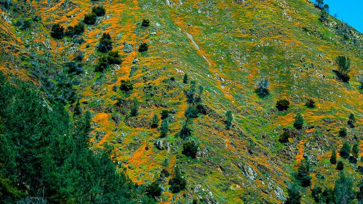
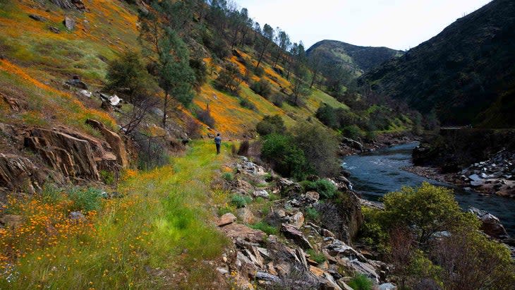
Hite Cove is a great hike every time of year except for the peak of summer, when it is closed for fire danger and would be blistering anyway. The poppy bloom peaks during March and April, bringing the hillsides alive with an explosion of orange. This hike starts 21 miles east of the town of Mariposa on Highway 140, at the confluence of the South Fork of the Merced and the Merced, outside of Yosemite National Park but in the Sierra National Forest. The trail snakes up a steep, narrow canyon, passing poppies, lupines, redbud, sky pilots, and baby blue eyes. The final view overlooks the side of the old mine. If on a hot day (which happens as late as October) you'd rather not commit to the challenge of the whole canyon, Estin says you can get a trip highlight right out of the trailhead: "The first half mile has ten times more flowers than the rest of the trail."
2. Incline Road
Distance: 28 total miles, but broken up into short sections of 2 to ten miles each
Difficulty Level: Easy
From 1907 to 1945, the Yosemite Valley Railroad carried passengers and freight along the Merced River Canyon for 28 miles, though not clear into Yosemite Valley. Just outside the valley, in El Portal, passengers had to dismount from the train and take horses and buggies on another road 14 miles into Yosemite Valley. There, after the rough journey, they reached their reward, starting with the overlooks showing them Bridalveil Fall and El Capitan, while Half Dome stared down on the Valley floor and Yosemite Falls flowed across the park.
Long ago, the old railroad ties on Incline Road, located just outside the park in the Sierra National Forest, were ripped up, leaving a wide trail that bends and turns as it parallels the Merced River. This mostly flat path, a great place to walk, has west and east access points, including Briceburg and at the end of Incline Road accessed from the trail on the North Fork of the Merced. Choose either of these starting points for a hike as short as two miles or as long as a dozen-plus. There are also plenty of sub-trails leading to the river, making nice detours. This whole trail is an excellent poppy-bloom viewing area in spring.
3. Wildcat Falls
Distance: .125, or an eighth of a mile, one way, .25 miles round trip
Difficulty Level: Easy
Wildcat Falls is a must jaunt, perfect for families and kids because it’s a short walk that leads to a small, stunning waterfall you can approach. "If you take your shoes off or wear river shoes, you can walk right up to it," Estin says. "It's also a great spot to take photos of your kids playing in the water." Wildcat Falls--which only runs in spring and early summer--is near Cascade Falls, but if you get to Cascade you've gone too far. You reach Wildcat Falls via an unmarked turnout on the left on Highway 140, 2.7 miles east of Arch Rock park entrance station at Arch Rock, Yosemite. The turnout allows parking for several cars, and while the trail is not marked, it's easy to see.
4. Cascade Falls
Distance: .25 to .5 one way, less than 1 mile roundtrip
Difficulty Level: Strenuous
Cascade is the first significant waterfall visitors encounter when entering the park. Though only 500 feet tall, the waterfall spills out of the wall with so much force that over the millennia it has created a huge swath of smooth river rocks below. Some of them are so slippery they feel like glass and squeak underfoot. There isn't a defined hike to reach the falls. But people want to get close to them and find a way, walking and crawling over the rocks. I have done this dozens of times, too, but beware that it requires river hopping and grabbing tree branches to keep balance.
Estin has a better idea for a way to the falls that is less direct but also less taxing in that it avoids the slick rocks. "There is a trail 200 yards upstream from the parking at the bridge where water from Cascade Falls flows through to meet the Merced River," he says. "It's unmarked and unmaintained, but it's the best way to reach the falls. You may have to hunt for it, but once you find the trail it leads right there." This trail cuts through the trees and climbs up and to the east side of the mouth of the falls, where you can look down on them. Though only half a mile, it's steep, so it packs a punch. "I only take people up there who are competent, as there is some rock scrambling involved," Estin says. It's a short, one-way adventure trail that can be reversed at any time if it's too much.
This stop is usually the first for people who have just been traveling for hours, and the bridge area has ample parking and nearby restrooms.
5. Four Mile Trail
Distance: 4.8 miles one way
Difficulty Level: Strenuous
This iconic trail is steep, with an elevation gain from 4,000 to 7,200 feet. Starting with views of Yosemite Falls, the Four Mile Trail rewards hikers with a changing landscape, as it switchbacks up past Sentinel Rock and ends at Glacier Point, which offers spectacular views of the Valley below, including of El Capitan. At Glacier Point there is a cluster of buildings with a gift shop, water fountain, and restrooms, and an overlook of the east end of the Valley, from which you can see Liberty Cap, Nevada Fall and Yosemite Falls in the distance.
From Glacier Point, visitors can reverse the trail, or make it a loop by continuing down the Panorama Trail (described below). However, Glacier Point Road is temporarily closed until May 2023, so for now if you go up you will have to walk back down the same way or on the Panorama Trail. When Glacier Point Road opens again, you can have a second vehicle parked at the top or arrange for a shuttle down to the Valley. By car, be sure to stop at the Taft Point trailhead 6.5 miles away on the way down to see one of the most magnificent overlooks in the park--it stares right over at mighty El Cap. You can hike 2.2 miles to Taft Point from the trailhead when the Glacier Point Road is open. Otherwise you can gain Taft Point by hiking the Four Mile Trail to Glacier Point, then taking the Pohono Trail another 3.4 miles.
6. Panorama Trail
Distance: 8.5 miles
Difficulty Level: Strenuous if going up, moderate if going down
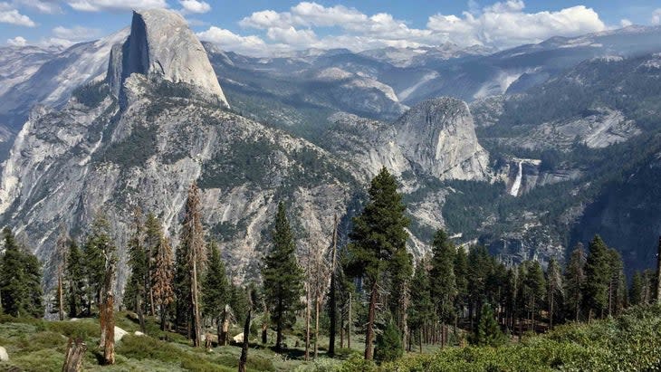
Passing Illilouette, Nevada Fall, and Vernal Falls, this wandering, circuitous path takes visitors along the east end of the Valley rim. In addition to bringing hikers back from Glacier Point to the Valley, the Panorama Trail connects to the Half Dome Trail (and Little Yosemite Valley), Clouds Rest, and Tuolumne Meadows to the east. As a National Park Service website notes, "Some of Yosemite’s most iconic natural features can be seen and experienced along this trail." Estin hikes this trail often because, he says, "It's spectacular--you see three huge waterfalls and views of Half Dome and Yosemite Valley." The top of the Panorama Trail is accessed from Glacier Point, which you reach via hiking, arranging a shuttle, or leaving a car (see road closures above). From the Valley floor, the Panorama Trail is accessed via Happy Isles.
7. Lower Yosemite Fall Trail
Distance: .25 mile one way to the Falls, .5 mile roundtrip, or a 2-mile round trip walk from Yosemite Village
Difficulty Level: Easy
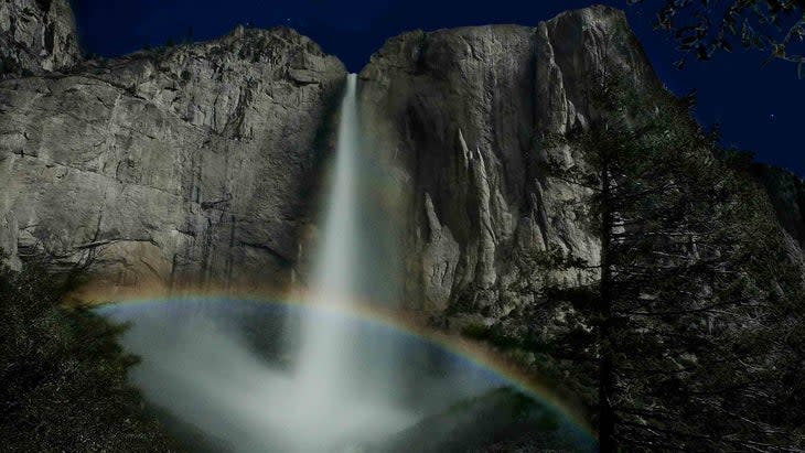
This quarter-mile paved trail from Yosemite Lodge to the base of Lower Falls is perhaps the most traveled path in the park, and is wheelchair and stroller accessible. The only caveat is that the last 75 feet are steep enough that a wheelchair would need assistance. "You have to push someone up there, which I've done many times," Estin says. In total, the trail gains 50 feet in elevation. As you hike in, views of Upper Falls (1,430 feet) filter through the trees, and once there, you get a direct view of the 320-foot Lower Falls. Additional benefits of the Lower Fall trail is that at the start of it are flushable toilets, picnic tables, and an ice-cold drinking fountain. I like it because from the viewing area along the footbridge that directly overlooks the Lower Falls--which also peers up at Lost Arrow Spire--I can scramble upstream and walk right up to the base of the Lower Fall. The National Park Service advises staying on the paved trail and says "Scrambling off-trail in this area has led to serious injuries." From April through June, you can see a nighttime moonbow here between 9 p.m. and midnight during a full moon.
Continuing past the bridge, the trail wanders through the trees, passes large boulders, and exits by the government stables.
8. Upper Yosemite Fall Trail
Distance: 7.2 miles round-trip
Difficulty Level: Strenuous
The not-to-be-missed, arduous 7.2-mile Upper Yosemite Falls Trail, started by the master early trailbuilder John Conway (who also designed the Four Mile Trail) in 1873 and taking until 1877 to complete, is accessed by the historic climbers' Camp 4, located to the west of Lower Falls. This trail is downright hard, ascending 2,700 feet via 60 switchbacks and on slick granite steps. But it's tough to find a more scenic trail in the park: this one offers the sights of Half Dome, Sentinel Rock, and the Tuolumne high country. From the top of Upper Yosemite Fall, a 15-minute hike from a marked trailhead takes you to Yosemite Point, providing unobstructed views of the Valley.
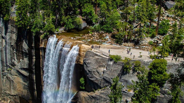
9. Vernal Falls
Distance: 2.4 miles round trip
Difficulty Level: Strenuous
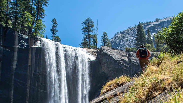
From the Happy Isles trailhead, it's just shy of a mile to reach the bridge that marks the start of the Mist Trail and its rainy and wet sections, especially when the falls are peaking. At Happy Isles visitors can refill water bottles from a fountain, throw on a poncho, and prepare to get soaked for 20 minutes hiking to the base of the fall. Many will stop at the bottom of Vernal Falls (317 feet), rather than continuing on the staircase carved out of granite rocks that winds up the cliffside above. Hand rails help visitors keep their balance but be careful, as the rails get soaked during peak season (April to June). The trail continues from the top of Vernal Falls to Nevada Fall (594 feet tall) and eventually Half Dome, seven more miles (permit required), and Clouds Rest, at nine more miles. By June, the waterfall ebbs and the mist recedes. The Mist Trail closes in winter due to frozen mist and snow.
To reach the start of the trail to Vernal Fall at Happy Isles (shuttle stop 16), catch the bus from Curry Village or walk for 20 minutes along the road or a parallel dirt path. (For traveling short distances like this, it's often faster to walk than it is to wait for the shuttle.)
Vernal Fall is 1.6 miles round trip from the footbridge to the base of the fall and 2.4 miles round trip if you go to the top. Nevada Falls is 5.4 miles round trip with an elevation gain of 2,000 feet.
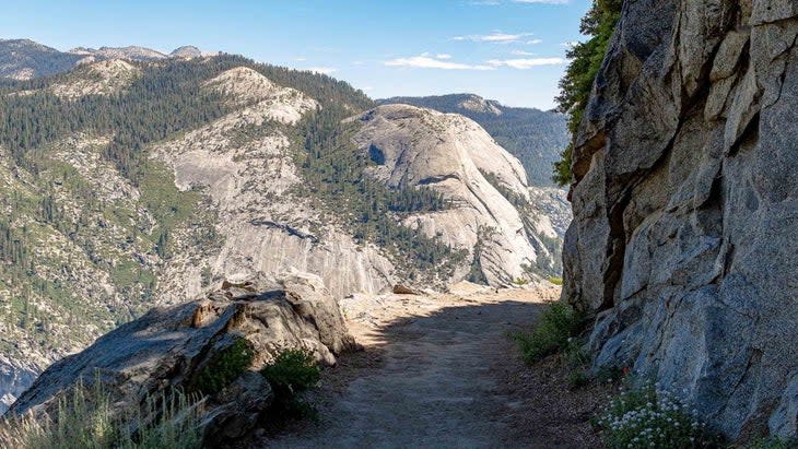
10. Half Dome Trail
Distance: 16.5 miles round trip
Difficulty Level: Strenuous
Despite a permit requirement and seasonal closures due to snow, this trail brings people to the park from all over the world. Starting at Happy Isles at 4,000 feet, it climbs to 8,839, gaining 4,800 feet. The Half Dome trail tops out at the Cables route, where in 1875 George Anderson painstakingly pounded in metal spikes to reach the summit, then considered impossible to attain. The park service issues 300 permits per day, with 225 for hikers and 75 for backpackers, by lottery. This hike is strenuous and beautiful, as it overlooks everything--cliffs, trees, and the little city of lights that make up the Valley floor below.
The last 400 feet of the Half Dome trail ascends the Cables route, opened in 1919, which is too steep for many (including the author's mom, who has been frequenting the park since the 1970s).
To break up the long hike, some people camp at Little Yosemite Valley, which I recommend as it's near water, spacious, and scenic. Permits are required.
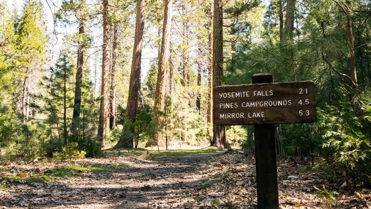
11. Mirror Lake
Distance: 2 miles round trip
Difficulty Level: Easy
This one-mile, one-way hike from the Ahwahnee Hotel to Mirror Lake follows a paved road and a parallel trail. Though called Mirror Lake, it only fills in April and is a sandbar for the remainder of the year. Once hikers reach the seasonal lake and sandy beaches, all great for kids for swimming, they take in the sights of willow trees and stunning views of Half Dome and Tenaya Canyon, which leads all the way to Tuolumne Meadows. Mirror Lake can also be a loop hike by walking past the Snow Creek Trailhead, crossing the Merced River and hiking back on the south side, which is about the same distance.
12. Snow Creek Trail
Distance: 9.4 miles round trip
Difficulty Level: Strenuous
Once you pass Mirror Lake, the path splits. The left fork climbs up the Snow Creek Trail--"the most strenuous hike in the Valley," as one longtime local, Paul Carrol, told me. (Continuing straight past the lake takes you up Tenaya Canyon.) Despite its steep, demanding nature, the Snow Creek Trail is still a top pick for many. Tucked in the eastern end of the Valley floor and laden with switchbacks, the trail offers epic views of Half Dome as it climbs from the Valley floor to the rim. The hike can be connected to the Upper Yosemite Falls loop, which at 18.8 miles makes for a backpacking trip instead of a day hike.
The top of Snow Creek rewards you with a postcard-worthy view, especially at sunset, from right below North Dome across the valley to Half Dome.
13. Tuolumne Grove
Distance: 2 miles round trip
Difficulty Level: Moderate
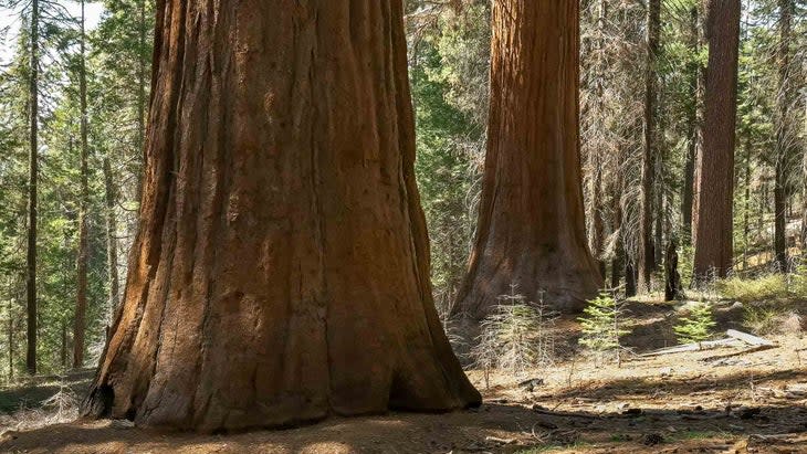
A quarter mile east of Crane Flat is parking for the Tuolumne Grove, comprised of 25 trees, and one of three ancient Sequoia groves in the park. The other two are the Merced Grove, with 20 trees, located six miles west at Crane Flat and accessed via a three-mile round-trip hike. And then there's the Mariposa Grove, the most popular and home to the largest sequoia tree in Yosemite, the 209-foot Grizzly Giant, among more than 500 mature trees. Though the Tuolumne and Merced groves are close together, the Mariposa Grove, as it's near the south entrance, is a 1.5-hour drive away (40 miles).
Several of the Tuolumne Grove trees are over 100 feet tall, and one is a tunnel tree that you can walk through. "One of my favorite guiding activities is to go and walk or crawl through the fallen tunneled-out tree," Estin says. "A fire hollowed it out, and you can walk inside it for 50 to 100 feet."
The paved path to the Tuolumne Grove is a mile downhill and is closed to cars. Just be prepared for huffing and puffing as you hike out, as you'll gain 500 feet of vertical over merely one mile.
Know Before You Go
Watch for poison oak, swift rapids, slick rock, and burning sun. Bring plenty of water and pace yourself, as on many hikes in Yosemite the terrain is steep and unforgiving. Though it rarely rains here six months out of the year, when it does it's often heavy. Bring a rain jacket.
Many of the trails pass over stone steps polished by countless shoe prints. The rocks are smooth and may be slippery. Wear good lug-sole trail shoes, and you can improve traction by choosing sticky-soled approach shoes made by climbing companies such as La Sportiva, SCARPA, and Five Ten.
Learn more about hiking safety in Yosemite here.
For exclusive access to all of our fitness, gear, adventure, and travel stories, plus discounts on trips, events, and gear, sign up for Outside+ today.

