The 11 Most Beautiful Hikes in U.S. National Parks
This article originally appeared on Outside
They say beauty is in the eye of the beholder. That is mostly true. Outdoor beauty, though, as found in nature, is far less subjective. I don't think anyone has stood on the lip of the Grand Canyon, peering down 5,000 feet, and thought, Meh. With that sense of scientific objectivity in mind, I've developed a list of the 11 most beautiful hikes in our national parks.
This list is about grand beauty--heart-stopping vistas and otherworldly landscapes that would make even the most jaded screen-ages look up from their phones and say, "Cool." I also considered geography diversity and a range of landscapes to highlight something for everyone. Same with difficulty--you'll find short half-mile loops and full-day efforts.
I am Outside's national parks columnist, fortunate enough to have hiked a number of these trails myself, and have dragged my kids to many. The rest of the trails haunt my bucket list for when the opportunities arise.
1. Sentinel Dome and Taft Point Loop, Yosemite National Park, California
Distance: 5.1-mile loop
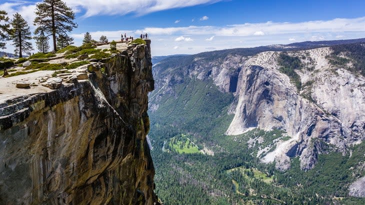
I knew Yosemite National Park was gonna make this list because of the 1,200-square-mile park's abundance of fertile valleys, dramatic waterfalls, and really big rocks. But choosing which ridiculously scenic hike to feature was agonizing. In theory, all of the best options look at the same stuff--Yosemite Valley and its granite towers--so I picked the hike with my favorite angle of that view. Tunnel View is probably the best-known vista, but it's just a roadside overlook, so I nixed it. Half Dome is arguably the most coveted (and badass) hike and leads to banger views of Yosemite Valley. But you know what you can't see from the top of Half Dome? Half Dome itself. So, ixnay.
Finally, I settled on the Sentinel Dome and Taft Point Loop because it offers two grand but distinct views of Yosemite Valley on the same hike. I had the opportunity to include a piece of this hike during a multi-day backpacking trip through Yosemite and was awestruck. The summit on Sentinel Dome has 360-degree views of the entire park, including west where Half Dome and a large chunk of Yosemite Valley are displayed in all their glory. From the vertigo-inducing Taft Point, you'll see El Capitan and Yosemite Falls.
The hike itself is moderate, with the only steep section coming as you approach the summit of Sentinel. It's less crowded than Glacier Point, too.
When to Go: This year late summer or early fall is best because Glacier Point Road is closed until July for snow plowing and road rehabilitation. If you're dying to see these views before the road opens, you can hike the 12.9-mile (one way) Pohono Trail, which climbs to Glacier Point from the Tunnel View Parking Area. It's a journey, and you'll get a series of breathtaking views of the Valley from Taft Point, Dewey Point, Crocker Point, Stanford Point, and Sentinel Dome.
Logistics: Yosemite is not requiring reservations to enter this summer, but you have to pay the park entrance fee ($35 per vehicle). The trailhead for this loop is off Glacier Point Road. Check the status of the road opening here.
2. Precipice and North Ridge Trails, Acadia National Park, Maine
Distance: 3.2-mile loop
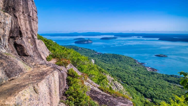
Do you want to walk along the wild Atlantic Ocean coastline, or take in the entire scene from above? That's the question when visiting Acadia National Park. Ocean Path is the most popular trail, and some say the most scenic. This 2.5-mile romp along the edge of Mount Desert Island has you traversing the beaches and rock outcroppings that help define this national park. But I'm disqualifying it here because you can drive the Park Loop Road and catch most of the views from pullouts at overlooks.
Instead, climb the difficult Precipice Trail to the top of Champlain Mountain for a bird's-eye view of the coastline, the Atlantic, and the many forested islands that rise from the water. It's a burly hike, climbing 1,000 feet in just .9 miles, that will have you scaling the sides of granite cliffs using metal rungs. You'll get a variety of coastal views, and see the vast New England coastline from the top of the trail. Take the Champlain North Ridge Trail off the mountain and the views will continue.
When to Go: Summer is the most popular season, but show up in the fall, and the forest leading from the base of the mountain to the water's edge will be aflame with red, orange, and yellow.
Logistics: Entrance fee is $35 per vehicle. If you're planning to drive Cadillac Summit Road while visiting the park, make reservations in advance.
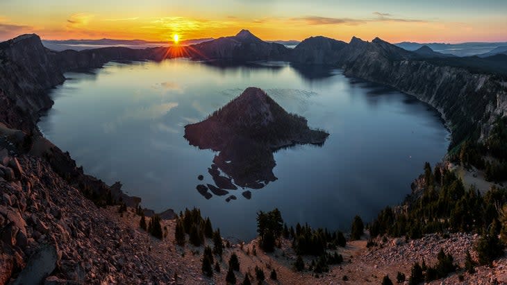
3. Watchman Peak Trail, Crater Lake National Park, Oregon
Distance: 1.6 miles roundtrip
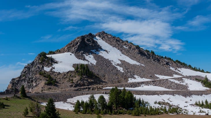
There isn't a bad view anywhere from the rim of Crater Lake, a 2,000-foot-deep lake nestled inside the bowl of a volcano sitting 7,000 feet above sea level. It sounds like the setting for a diabolical mastermind's secret base, but simply creates one of the most spectacular national parks in the country. The lake is considered among the most pure in the world, as the water is sourced completely from rain and snow.
The views from the edge of the volcano are one of a kind. Watchman Peak Trail is a little harder than "nature walk" territory--it gains 420 feet in under a mile to a historic fire lookout tower--but it gets the same kind of volume of visitors as a paved overlook trail, and the view is why. This is one situation where the hike isn't about the journey, only the destination, because at the crest of the trail you can see the entire lake from a stone platform below the woodend fire tower. The view encompasses Wizard Island, a smaller volcano set inside a larger volcano. If you want a good view with fewer neighbors along the way, hike the 3.7-mile round trip to Garfield Peak, which takes in most of the lake from a different angle. Bonus for the Garfield Peak hike: In the summer, the hillsides are blanketed in wildflowers.
When to Go: Crater Lake is covered in snow most of the year, so summer and early fall are your best bets. Sunset is stunning, but you definitely won't have the view to yourself.
Logistics: You'll have to pay an entrance fee of $30 per vehicle. As of early summer 2023, portions of Rim Drive are still closed for snowplowing. The road is usually cleared by mid-July. Keep an eye on road conditions here.
4. Bright Angel to Plateau Point Trail, Grand Canyon National Park, Arizona
Distance: 12 miles out and back
The Colorado River has carved out quite the ditch as it makes its way south across the Kaibab Plateau, and Grand Canyon National Park protects the most dramatic slice of the 277-mile-long gorge. Because this national park is so damn big, there are amazing views all over. The sights from various easy-to-access overlooks along the rim are awe-inspiring, but the views get even better, if that is possible, as you hike deeper into the gorge. A few trails drop off the rim, but for views, I like the Bright Angel Trail. Based on the number of people who hike it every year, so does everyone else.
Don't let the crowds dissuade you, though, as this hike is a life-changer, dropping 3,200 feet in six miles as it switchbacks down the side of the Grand Canyon. The views are fantastic the whole way, and you'll walk through the vibrant Havasupai Garden, an oasis that once supported a Native American population. It's also quite the challenge; I hiked the full Bright Angel as an out and back in my early 20s and it's still one of the toughest hikes I've ever done. Most people make the full Bright Angel a multi-day hike, staying at either Havasupai Campground or Bright Angel Campground, but I wasn't able to score a reservation at the time.
The best vista is at Plateau Point on the edge of Tonto Plateau, roughly 2,000 feet above the Colorado River. Reach the overlook by taking a short spur trail at mile 4.5 and hiking the 1.5 miles for a front-and-center view of the inner gorge, as well as the aqua waters of the Colorado River, roughly 2,000 feet below.
When to Go: The South Rim is open year-round, but most agree spring and fall are the best time to visit because of milder temperatures. If you're visiting in the summer, start your hike as early as possible to avoid the heat.
Logistics: You have to pay the entrance fee ($35 per vehicle). The hike begins at the Bright Angel Trailhead on the South Rim's Desert View Drive. Bring more water than you think you'll need as the temperature will rise as you drop deeper into the canyon. Remember, the 6-mile way down to Plateau Point is easy, but the 6-mile climb back up to the rim is hard.
5. Forney Ridge Trail to Andrews Bald, Great Smoky Mountains, North Carolina and Tennessee
Distance: 3.6 mile out and back
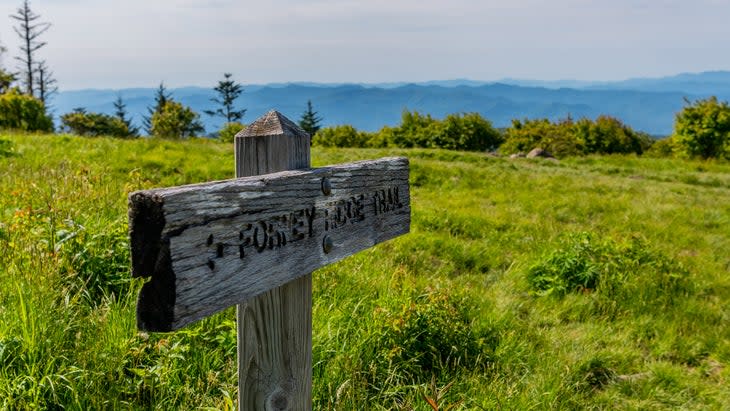
Great Smoky Mountains National Park protects 500,000 acres of the Southern Appalachians along the North Carolina and Tennessee border. The terrain is a mix of pastoral valleys with historic homesteads and steep, rugged peaks rising to 6,000 feet above sea level. This region is a temperate rainforest, with a lush canopy and dense woods, so long-range views can be tough to find. That's one of the reasons I love Forney Ridge Trail, which ends at Andrew's Bald, a high-elevation pasture once used to graze livestock, giving the 5,906-foot mountain an above-treeline vibe. Hike Forney Ridge Trail from the Clingman's Dome parking lot and you'll travel through a thick forest until reaching the bald proper, where several acres of tall grass offer long-range views of the southern mountains of the park and Fontana Lake. I've hiked this trail a couple of times over the years and I'm always amazed to be the only person on the path. Clingman's Dome can be a zoo of people, especially in the summer, but most of those people stick to the concrete lookout tower and never venture on the actual trails.
When to go: You can hike the Smokies year-round. In the winter you'll have the park more or less to yourself, and in the fall, the forest blazes with color. But knock out this hike in June and early July and you will find the Rhododendron and flame azaleas in full bloom.
Logistics: The hike begins at the parking lot for Clingman's Dome, a concrete lookout you will want to spend a few minutes climbing. There's no entry fee to enter Great Smoky Mountains National Park, but you have to purchase a parking tag ($5) to park at any trailhead.
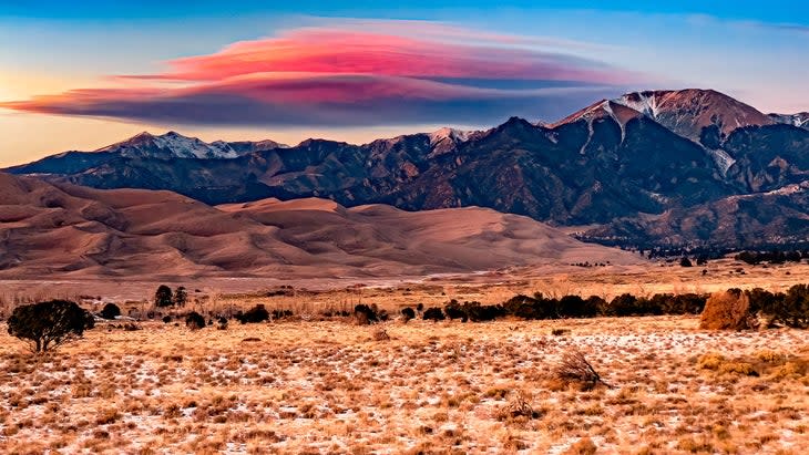
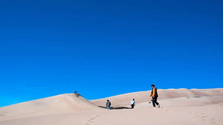
6. High Dune, Great Sand Dunes National Park and Preserve, Colorado
Distance: 2.5 miles out and back
Great Sand Dunes National Park is wild, encompassing 30 square miles of off-white mounds of sand within the Rocky Mountains. These are the tallest dunes in North America, rising up to 741 feet. The sheer volume of sand here makes for other-worldly photo opportunities.
There are no established hiking trails throughout the dune field, but most visitors head towards High Dune, a 693-foot "peak" on the first ridge beyond the main parking lot (other hikes here). From the top of High Dune, you can see the rolling hills of sand spread across the landscape, all flanked by the 13,000-foot Sangre de Cristo Mountains. You might feel like you're in a vast desert, but in the spring and early summer, the hike actually begins with a stream crossing, as Medano Creek runs wide and several inches deep with the snowmelt. Pack an innertube in your car. The crumbling sands send waves down the creek that you can tube, and access is a short walk from the parking lot.
When to Go: The dunes can be covered in snow in the winter, and the sand can get really hot in the summer. Spring and fall are your best bets, but if you do show up in the summer, cool off in Medano Creek.
Logistics: Entrance fee is $25 per vehicle. You can park near the visitor center.
7. Mesa Arch, Canyonlands National Park, Utah
Distance: .5-mile loop
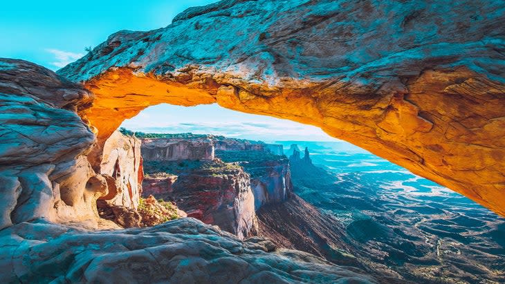
I know, all the great sandstone arches are across the street in Arches National Park, right? Wrong. The 258,000-acre Canyonlands has plenty of fascinating sandstone features throughout, and while Mesa Arch isn't the largest natural bridge in the region (it's 27 feet across), it's perched on the edge of a cliff, 1,200 feet above Buck Canyon. As a result, the natural bridge provides the perfect frame for peering into (and photographing) the belly of Canyonlands.
Looking through the arch, you can see Washer Woman and Monster Tower, two distinct Wingate formations that are popular with climbers, the White Rim Trail (a classic multi-day mountain-bike route), and off in the distance, the La Sal Mountains. The walk is an easy .5-mile lollipop loop, which makes it extremely popular, but also a great option if you're toting along children. My wife and I took our twins on this hike when they were age four. They probably had more fun scrambling on the sandstone outcroppings that surround the trail, but Liz was pretty pleased with the family photos of us at the arch. So everyone wins.
When to Go: Any time is a good time to visit Canyonlands, but summer is hot and crowded, and winter can be snowy and empty. Spring and fall can offer ideal weather and fewer crowds. Regardless of the season, show up at sunrise, and the red cliffs below the arch practically glow as the sun hits the sandstone.
Logistics: Entrance fee is $30 per vehicle. While Arches has brought back timed-entry reservations, you don't need them to visit Canyonlands. The Mesa Arch Trailhead is located in the Island in the Sky district, off Grand View Point Road.
8. Highline Trail, Glacier National Park, Montana
Distance: 12 miles, one way
Glacier National Park is packed with scenery. Hidden Lake might be one of the prettiest in the country, Going-to-the-Sun Road lives up to all the hype, and yes, as the park name suggests, there are glaciers too. Set in that context, Highline Trail at Glacier National Park makes our cut because of the accumulation: it's not one vista that makes this trail so damn beautiful, it's the collection.
The highlights start right out of the gate as you traverse along a narrow ledge half way up the side of a cliff, peer back over Going-to-the-Sun Road below, and catch long-range views of Mt. Cannon, Mt. Oberlin and Heavens Peak to the west. The next few miles deliver you into pocket forests and meadows full of wildflowers in the lush area known as the Garden Wall. The wildflowers are nice, but the views deep into the park are even better, and they just keep coming as you climb to Haystack Pass and begin your descent towards Granite Park Chalet, a backcountry lodge with its own views. Take the spur trail to Grinnell Glacier Overlook, and climb a mile to the Continental Divide to see the teal lake at the bottom of the Grinnell Glacier, where Grinnell Falls tumbles over a rock wall.
A forested bowl below the cirque surrounding Upper Grinnell Lake holds a series of alpine lakes. This is arguably the best view on the trail, and some would say in the park as a whole. Backtrack to the Highline Trail and it's a mile to Granite Park Chalet, and then four miles through mostly forested terrain to the Loop, where you can take the free shuttle back to Logan Pass.
When to Go: Going-to-the-Sun Road is closed from October to early June, so you're relegated to late summer and very early fall for this hike.
Logistics: Highline Trail starts at Logan Pass, off Going-to-the-Sun Road. This summer, you have to make advance reservations to drive the road between 6 A.M. to 3 P.M. daily ($2). If you didn't make a reservation four months in advance (when the majority are released), you can roll the dice and try for a slot 24 hours in advance. You'll also have to pay the entrance fee of $35.
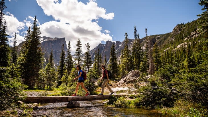
9. Glacier Gorge Trail to Sky Pond, Rocky Mountain National Park, Colorado
Distance: 8.5 miles out and back
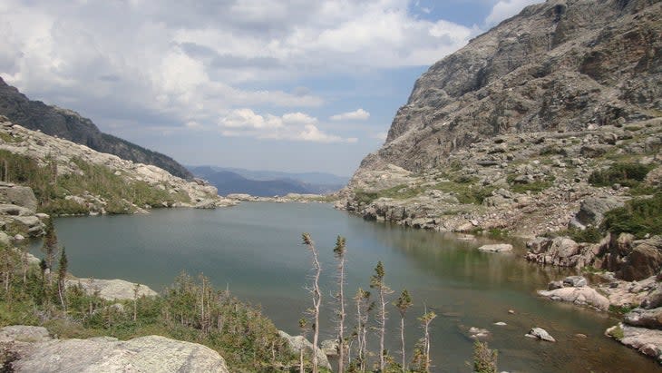
Rocky Mountain National Park is full of high-elevation peaks and backcountry alpine lakes, and the 9.5-mile out and back to Sky Pond shows you a lot of both. There are more popular lake hikes in RMNP, and certainly easier lakes to reach, but the remoteness of Sky Pond is part of the draw, as is the water itself, mirroring the granite cirque that surrounds it.
On the hike, you will pass the 30-foot Alberta Falls as they drop through a gorge on Glacier Creek; then traverse the shores of Loch Vale, a small lake at 10,190 feet with views of 13,000-foot Taylor Peak and Taylor Glacier on the horizon; and end at Timberline Falls, rushing 100 feet over a granite cliff. Towards the end of the hike, a mandatory rock scramble leads you to the Lake of Glass, which sits beneath a trio of granite peaks (the Sharkstooth, Taylor Peak, and Powell Peak). You think you're done, but you're actually hiking to the even prettier lake, Sky Pond, on the other side of those peaks. Sky Pond is surrounded on three sides by sheer granite walls, which descend directly to the edge of the lake.
When to Go: Considering the elevation, summer or early fall is your window. It's a long, difficult effort, so start early if you can.
Logistics: The hike starts at Glacier Gorge Trailhead on Bear Lake Road. Between May 26 and October 22, you have to reserve a timed entry ($2) to visit Bear Lake Road between 5 A.M. and 6 P.M., which will give you a two-hour window to enter the road. You'll also need to pay the $35 entrance fee to the park.
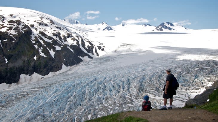
10. Harding Icefield Trail, Kenai Fjords National Park, Alaska
Distance: 8.2 miles out and back
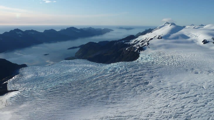
There are glaciers, and then there's the Harding Icefield, a frozen tundra that stretches for 700 square miles connecting 40 separate glaciers, which act as drains. This giant, changing ice cube is the central feature of Kenai Fjords National Park, and the largest icefield in the United States. Mountain peaks, called nunataks, rise from the ice. It's a tough hike to reach the edge of the Harding Icefield, climbing 3,000 feet in just over four miles, but the massive expanse of ice isn't the only reason to tackle this journey.
The views throughout the trail are outstanding, from the cottonwood forests and meadows in the first portion of the adventure to the Cliffs Overlook at mile 2.4, which shows the Icefield above Exit Glacier. Even the view back towards the trailhead, where the wide Exit Creek bisects the green Outwash Plain, is stunning. Continue across patches of snow to the end of the trail at a rocky outcropping hovering over the edge of the Harding Icefield. A massive expanse of snow and nunataks, black against the white icefield, stretches towards the horizon.
When to Go: The upper portions of the trail can be covered in snow into July, so aim for late summer, and check trail conditions before your hike.
Logistics: Park at the end of Herman Leirer Road, the only road in Kenai Fjords National Park. There's a visitor's center with restrooms at the parking lot. Entrance to the park is free.
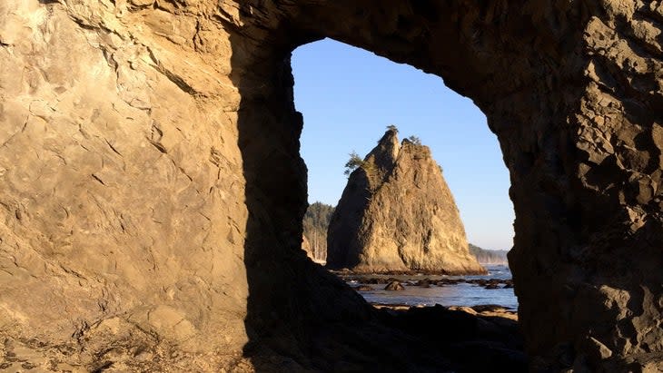
11. Hole-In-the-Wall, Rialto Beach, Olympic National Park, Washington
Distance: 3.4 miles out and back
You want landscape diversity? Olympic National Park has landscape diversity. This million-acre park in Washington covers a variety of ecosystems, from glaciated peaks to lush rainforest to wild coastline. You can't go wrong with any hike inside the park, but the coast, where Washington hits the Pacific Ocean in an abrupt line of rock and forest, is gorgeous. There are 70 miles of coastline to choose from, but I like the hike along Rialto Beach to the Hole-in-the-Wall, a large sea stack just off the beach with a small arch forming in its flank.
The hike is a beach walk along a stretch of black sand peppered with big rocks and ghost-white driftwood. Start at Rialto Beach Trailhead, seeing forested islands off the coast to the south, and head north as sea stacks rise from the water beyond the breakers and an impossibly green forest edges the beach to your right. After two miles you'll hit Hole-in-the-Wall.
When to Go: Summer is your best bet if you're looking for warm temps and the chance to get in the water (the ocean will still be cold, though). If you time your arrival for low tide, you can scramble up the sea stack and explore the small arch. There's also a primitive trail that climbs an outcropping on the forest side of the beach, offering a panoramic view of the sea stack, beach and ocean to the south.
Logistics: Entrance to the park is $30 per vehicle. Park at the Rialto Beach Trailhead and walk north.
Graham Averill is Outside magazine's national parks columnist. In his early 20s, with no training and very little hiking experience, he thought it was a good idea to hike Bright Angel Trail down to the Colorado River and back on the same day. It wasn't.
For exclusive access to all of our fitness, gear, adventure, and travel stories, plus discounts on trips, events, and gear, sign up for Outside+ today.

