These 11 Routes Across the U.S. Have the Ultimate Fall Foliage Views for Your Next Ride

Leaf-peeping is practically a rite of passage in the fall. Like carving pumpkins or picking apples, checking out the fall foliage—leaves transforming from their summer greens to the burnt oranges, vibrant fuchsia-reds, and rich golden yellows—is a sure-fire way to get into an autumn mood and make the most of this transitional season.
And what better way to experience this natural spectacle than from your bike?
Sign up for Bicycling All Access for all kinds of expert tips and advice 🚲
We chatted with cyclists to learn the best routes all over the country for experiencing the fall foliage on two wheels. The rides are broken into eight different regions—Northeast, Mountain West, Southwest, New England, South, Midwest, California, and Pacific Northwest. And for each ride, we give you relevant details to help you plan your adventure, in addition to an expert tip.
Whether you’re a road cyclist, a gravel rider, a mountain biker, or all of the above, we’ve got you covered.
NORTHEAST
The Erie Canalway Trail

Location: Western New York
Length: 32 miles one-way
Estimated time to complete: 3 hours
Best time of year to go: Late October
Type of ride: Paved trail with some crushed stone
The details: The Erie Canalway Trail is a seriously impressive trail spanning more than 360 miles between Albany, New York, and Buffalo, New York. As the name suggests, the flat trail follows one of the most famous manmade waterways, the historic Erie Canal, which opened in 1825.
For the best fall colors, consider riding the 32-mile segment between Buffalo and Lockport. In addition to brightly colored leaves, you’ll get to see the special “Flight of Five” locks that help transport boats up and over an escarpment near Lockport. Spend the night before heading back on the trail, or ride the full 64 miles roundtrip in one day.
Expert tip: Give yourself plenty of time to stop at various historic sites and iconic lift bridges along the way, said Rebecca De La Cruz with Parks & Trails New York, a nonprofit that helps manage and maintain the trail. Be sure to wear or bring waterproof clothing, too, as the region tends to get rain in the fall.
Erie Canalway Interactive Trail Map
MOUNTAIN WEST
Flash of Gold

Location: Steamboat Springs, Colorado
Length: 11.3 miles roundtrip
Estimated time to complete: 2-3 hours
Best time of year to go: Late September to mid-October
Type of ride: Mountain bike
The details: The name basically tells you everything you need to know: Flash of Gold is a mountain bike trail in Steamboat Springs with incredible yellow-leafed aspen trees in the fall. This out-and-back route is part of a broader trail system in the Buffalo Pass area, so you can keep riding if you don’t get enough fall colors on Flash of Gold. The trail transitions from smooth and flowy switchbacks with a mellow grade to a narrower, more technical hand-built trail that climbs 1,700 feet to the top of the pass.
“For climbing a steady grade and taking in spectacular vistas and fall colors, it doesn’t get much better than Flash of Gold,” said Amy Charity, a retired professional cyclist, cycling coach, and race director of SBT GRVL, a new gravel race in Steamboat.
Expert tip: “For a longer day in the saddle, consider starting downtown at the Spring Creek Trailhead,” Charity said. “This will add an additional five miles of climbing to the ride.”
Alternatively, if you start feeling uncomfortable with some of the more technical riding on the trail, there are tons of bailout options to hop onto Buffalo Pass Road, Charity said.
Flash of Gold interactive trail map
Maroon Bells
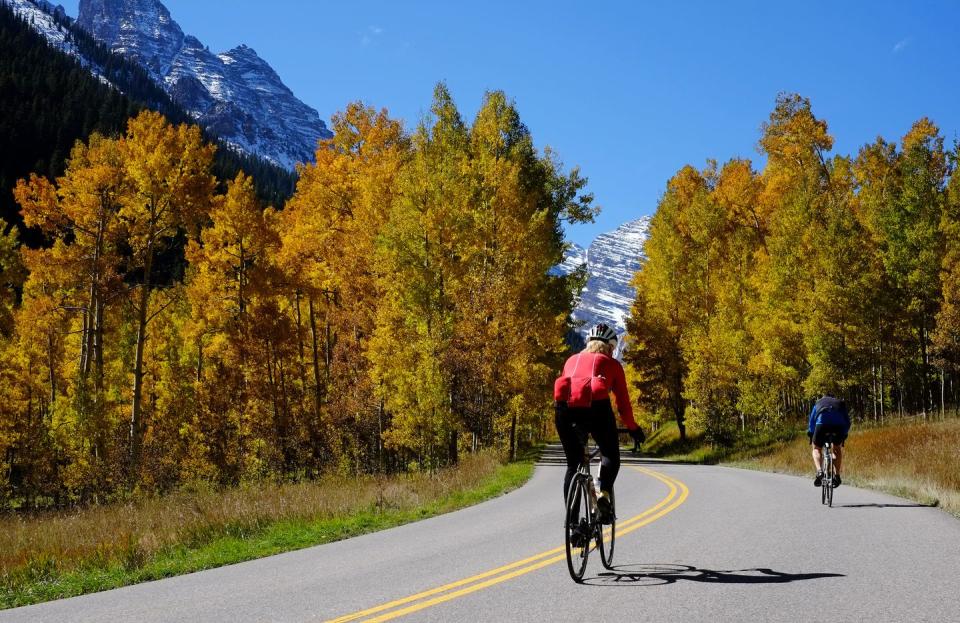
Location: Aspen, Colorado
Length: 20 miles roundtrip
Estimated time to complete: 2 hours
Best time of year to go: Mid- to late September
Type of ride: Road
The details: The Maroon Bells are touted as two of the most photographed peaks in North America—and it’s easy to see why, especially in the fall, when the aspen leaves turn a rich golden-yellow hue. You can ride up to Maroon Lake on your road bike to snap a few photos of the peaks yourself.
The best part? You’ll have the road almost entirely to yourself, except for other cyclists (this is a beloved local route, so you’ll be in good company, too). Right now, nearly all vehicles are banned from driving this route between 8 a.m. and 5 p.m. At most, you’ll be passed by two or three shuttles and city buses, but that’s it.
The ride climbs 1,700 feet in 10 miles, so make sure you take it easy and bring plenty of water if you’re not accustomed to the altitude (Aspen sits at 8,000 feet to begin with!).
Expert tip: E-bikes are everywhere in Aspen this summer, including on the ride up to Maroon Lake. If you’d prefer to avoid riding with e-bikes, consider riding before 10 a.m., according to Erik Skarvan, a longtime Aspen cyclist and the owner of Sun Dog Athletics, which offers cycling lessons and tours. Also keep your eyes peeled for wildlife, including bears and moose, and be sure to give them a wide berth.
“Be extra careful, bull moose can be extra aggressive in the fall rut or mating season,” Skarvan said.
SOUTHWEST
South Boundary Trail
Location: Northern New Mexico
Length: 21 miles one-way
Estimated time to complete: 3.5 to 4 hours
Best time of year to go: Mid- to late September
Type of ride: Mountain bike
The details: The South Boundary Trail is an iconic mountain bike ride in northern New Mexico. It’s even better in the fall, when the massive aspen groves that surround the trail create a shimmering gold spectacle.
If you don’t want to do the whole 21 miles, which will have you climbing 1,600 feet before descending 4,300 feet, you can chop the ride in half by dropping in at Garcia Park. This ride is so good that it earned the coveted “IMBA Epics” designation, a special crowd-sourced accolade for trails that are both challenging and beautiful from the International Mountain Biking Association.
Expert tip: If you’re coming from Taos, New Mexico, take a shuttle to the start of the trail near Angel Fire. This saves you the headache of trying to coordinate two vehicles, one at the start and one at the finish, and it will also probably just save your car more broadly—the road from Taos to the start of the trail is burly, said Chris Hale, who runs the shuttle and owns Gearing Up Bike Shop.
“Somedays, depending on the weather, it’s like getting a rock-crawling ride and a bike shuttle for the same price,” Hale joked.
And, no matter your skill level, be sure to bring at least two to three liters of water, Hale advised. This route takes you to 10,000-plus feet in elevation.
South Boundary Interactive Map
NEW ENGLAND
Bethel to Evans Notch

Location: Western Maine and eastern New Hampshire
Length: 27 miles roundtrip
Estimated time to complete: 3 to 4 hours
Best time of year to go: First half of October
Type of ride: Road
The details: The motto of Bethel, Maine, is “Maine's Most Beautiful Mountain Village” and it’s easy to see why after you complete this colorful ride. You’ll head north out of Bethel and cut over to North Road, which offers gorgeous views of the Androscoggin River and the White Mountains off in the distance. The route climbs gently to Evans Notch, a mountain pass with stunning views. Return to Bethel or continue on to Gorham, New Hampshire, for a longer ride that climbs roughly 1,700 feet in elevation.
Expert tip: The ride is rural and remote once you leave Bethel (unless you decide to continue on to Gorham), so be sure to bring enough supplies. Bring layers to wear in the morning, as temperatures typically start in the 30s and 40s before warming up to the 60s during the fall, according to Norman Patry, owner of Summer Feet Cycling in Portland, Maine. After the ride, hit up Suds Pub for a beer.
“For a longer, more challenging ride, descend Evans Notch toward Fryburg, Maine, and make it a century,” Patry said.
Bethel to Evans Notch Interactive Map
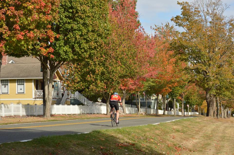
Where’s Chester?

Location: Northeastern Massachusetts and southern New Hampshire
Length: 54 miles
Estimated time to complete: 4 hours
Best time of year to go: Mid- to late October
Type of ride: Road
The details: This colorful ride is popular with members of the North Shore Cyclists club north of Boston. Along the way, you’ll pass through farmland and historic country towns while gaining 2,500 feet in elevation. There are some challenging hills to climb, but you’ll hardly notice because you’ll be so distracted by the red, orange, and yellow leaves.
Expert tip: Stop for lunch or a snack at the Chester General Store, according to Jim Goldberg, a North Shore Cyclists board member and the director of Easy Rider Tours. And be sure to snap a few photos of the creative and often hilarious scarecrows all over Chester, which hosts a fundraiser for the local historical society every fall.
Where’s Chester Interactive Map
SOUTH
Natchez Trace Parkway
Location: Alabama, Mississippi, and Tennessee
Length: 32 miles one-way
Estimated time to complete: Varies
Best time of year to go: Late October and early November
Type of ride: Road
The details: OK, so maybe you don’t plan to ride the entire 444-mile parkway—but you could if you wanted to, and you’d see a new batch of fall colors each day as you made your way from north to south. The parkway, which is completely free of commercial vehicles, is basically a rolling leaf-peeping venue—the leaves start turning in Tennessee in mid- to late-October, then continue to turn in late October and early November as the trail meanders southward through Alabama and Mississippi. You could pick a colorful stretch of the parkway to ride based on your schedule. (The National Park Service even updates a handy leaf report on its website!)
One section worth trying? The flat stretch in Mississippi between the Parkway Visitor Center and the Witch Dance campground, which is open to bicyclists only. This 32-mile stretch takes you through Tupelo, Mississippi, perhaps best known for being the birthplace of Elvis Presley, and through the scenic Tombigbee National Forest.
Expert tip: “It’s very important to allow for extra time along the way to stop at the visitors center in Tupelo and other historic sites,’ said Jeff Snyder, a member of the Frog Island Flyers Racing Team in Tupelo. “I love to spend time in the saddle, but there are so many things to see along the way, stopping and soaking it up is unavoidable.”
There are bathrooms every 20 or 30 miles, Snyder said. And, since it’s managed by the National Park Services, park rangers are never too far away if you need assistance.
Natchez Trace Parkway interactive map
MIDWEST
Chief Standing Bear Trail

Location: Southern Nebraska
Length: 22.5 miles one way
Estimated time to complete: 4-6 hours
Best time of year to go: Late September or early October
Type of ride: Crushed stone
The details: Chief Standing Bear Trail is a crushed limestone rails-trail that runs from Beatrice, Nebraska, to the state’s border with Kansas (you can keep riding into Kansas for another 11.7 miles if you choose!). Not only does this flat trail have beautiful fall colors, but it also honors the Native Americans who first inhabited this land. The trail is owned by the Ponca Tribe of Nebraska and was named for the tribe’s chief, Standing Bear.
“This whole route follows old rail lines and gives you the opportunity to connect with the history of the Ponca Tribe and the local landscape,” said Alex Duryea, an avid cyclist and the recreational trails manager for Nebraska Game and Parks. “That, along with the scenery along the Big Blue river which this trail parallels, makes this route one of my favorites.”
Expert tip: “For more time in the saddle, this trip can be started in Lincoln, Nebraska, by taking the Homestead Trail from Lincoln to Beatrice and then linking up with Chief Standing Bear Trail for an additional 60 miles roundtrip to make a century ride,” Duryea said.
CALIFORNIA
June Lake Loop
Location: Eastern Sierra, California
Length: 24-mile loop
Estimated time to complete: 1.5 to 2 hours
Best time of year to go: Mid- to late September
Type of ride: Road
The details: You’ll be amazed at the natural beauty and the fall colors along this route, which takes you past four lakes: June Lake, Gull Lake, Silver Lake, and Grant Lake. This mellow ride cruises through the community of June Lake, a four-season outdoor recreation paradise just north of Mammoth Lakes that’s often referred to as the “Switzerland of California.”
Start at the parking lot at the junction of Highway 395 and June Lake Loop Road, then head southwest into town and past June Lake itself. Continue on the road past Silver Lake and Grand Lake, taking time to stop and enjoy the views of June Mountain Ski Area. After your ride, grab a beer at June Lake Brewery and a meal from the O'Hana's 395 food truck.
Expert tip: June Lake sits at 7,600 feet in elevation, so take it easy, especially if you just arrived in the mountains, said cyclist Caroline Britton. The ride itself gains approximately 1,500 feet in elevation.
“You really want to make sure you stay hydrated and that you’re pacing yourself,” she said. “Anticipate things just taking a little bit longer. But at the same time, it’s awesome because that’s another way for you to take in the scenery and really enjoy the views.”
And just because the temperatures are cooler in the fall, don’t let the weather fool you into forgetting your nutrition and hydration, Britton said.
Please note that as of publish, the air quality of the June Lake Loop is at a very unhealthy level because of the recent wildfires. Before planning to ride this route, check the air quality of the area.
June Lake Loop interactive map
Edna Valley Loop
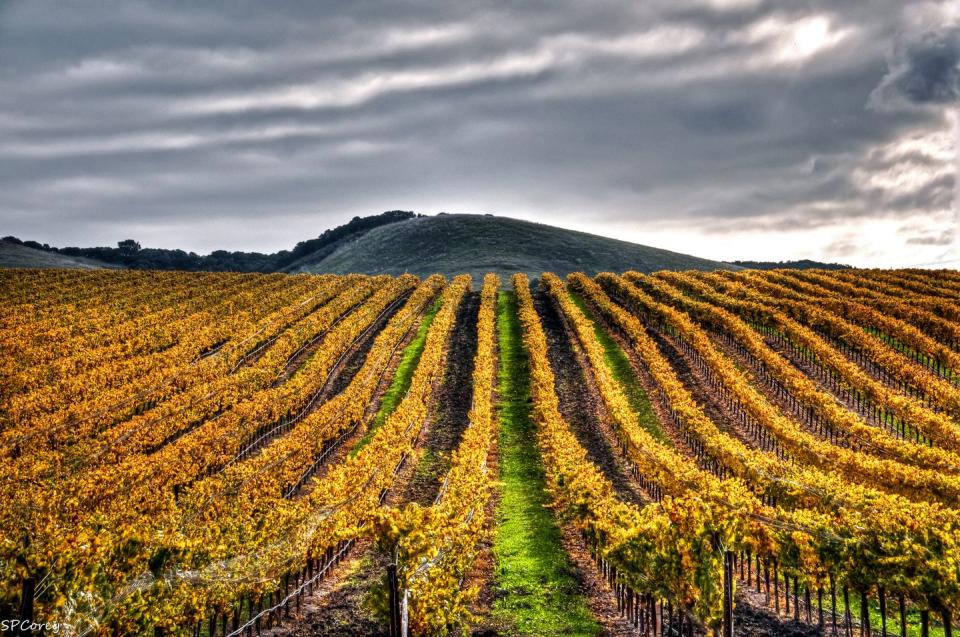
Location: Central Coast, California
Length: 14 miles
Estimated time to complete: 1 to 2 hours
Best time of year to go: Mid-October and early November
Type of ride: Road
The details: For something a little different, consider riding the Edna Valley Loop through San Luis Obispo wine country. You won’t see aspens or maples; instead, you’ll see the gorgeous autumn colors of the grapevines, which turn bright red, orange, and yellow in the fall after the grape harvest. You’ll want to give yourself extra time to stop and take pictures, since the vines are laid out in symmetrical rows that create truly stunning views.
This loop is moderately hilly, with roughly 830 feet of elevation change, but it’s short and sweet. Start your ride at Islay Hill Open Space, where there’s plenty of parking, then cruise south out of town on Orcutt Road.
Expert tip: “Stop at a winery and enjoy some of the local wines,” said John Flaherty, owner of Central Coast Outdoors. “Some of our favorites are Baileyana, Chamisal, and Saucelito Canyon.”
Edna Valley Loop interactive map
PACIFIC NORTHWEST
Kitsap Color Classic
Location: Puget Sound region of Washington
Length: 29, 39 or 57 miles
Estimated time to complete: 1.5 to 6 hours
Best time of year to go: End of September
Type of ride: Road
The details: The Kitsap Color Classic is a popular annual event that winds through the beautiful gold and amber leaves on the Kitsap peninsula. Unfortunately, the event is canceled this year because of COVID-19, but you can still tackle the ride on your own or with a few close friends.
You’ll start with a Puget Sound ferry ride from Edmonds to Kingston, then choose between three loops with varying lengths and elevation gains. The shortest loop climbs 1,703 feet, while the longest loop gains 3,844 feet of elevation.
Expert tip: The ride passes through the historic town of Poulsbo, which is nicknamed “Little Norway” because it was founded by Norwegian fisherman. After your ride, visit the maritime museum or stop for a pastry at Sluys Poulsbo Bakery, which dates back to the early 1900s, recommended Paul Tolmé of the Cascade Bicycle Club, which organizes the Kitsap Color Classic. And be prepared for rain or sun—this is the Pacific Northwest, after all.
Please note that as of publish, the air quality of the Kitsap Color Classic route is at an unhealthy level because of the recent wildfires. Before planning to ride this route, check the air quality of the area.
Kitsap Color Classic interactive map
You Might Also Like

