10 Most Beautiful Walking Paths in the U.K. — With Views of the Seaside, Snowcapped Peaks, and Mystical Glens
The U.K. is best explored on foot — particularly if you want to take in the glorious countryside and plenty of fresh air.

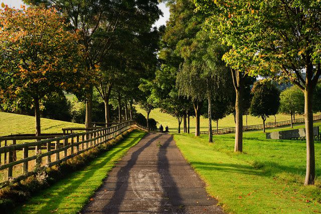
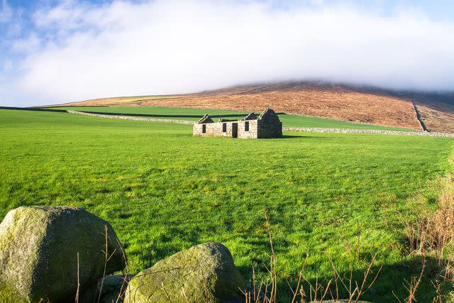
R A Kearton/Getty Images
You can call it a walk, a hike, or simply a ramble, but trekking through the great outdoors in the United Kingdom is a rite of passage for tourists and a popular hobby for locals. Not only is the country ripe with diverse landscapes — seaside cliffs, grassy moors, snowcapped peaks, rocky hills, and mystical glens — but it’s also riddled with trails that provide access to some of the most stunning scenery in the world.
While you should download the AllTrails app to easily pinpoint walks and hikes during your visit, you’ll also want to keep an eye out for signs that signal “public rights of way.” Like its name suggests, these are paths and pieces of land that walkers can use at all times. In England, Wales, and Northern Ireland, public rights of way are marked with colored signs — yellow for footpaths and blue for bridleways (paths where horse riding and biking are allowed). In Scotland, you’ll find green and white signs communicating these routes.
No matter where you go in the U.K., you’re bound to discover walking paths in a variety of lengths and levels — from beginner-friendly strolls to more adventurous, multiday excursions. If you’re looking to tackle longer-distance trails, specifically, the National Trails of England and Wales or Scotland’s Great Trails are great places to start. Otherwise, grab a Barbour jacket and a quality pair of boots, and keep reading to discover some of the best walking paths in the U.K.
Cotswold Way, England
Marc Guitard/Getty Images
From start to finish, the Cotswold Way is 102 miles of picturesque villages, historic sites, and remarkable views of the English countryside. The trailhead is located in Chipping Campden, in the north section of the Cotswolds, and Bath Abbey marks the finish line (plaques denote the official start and endpoints at either location). Between the two, walkers pass through charming towns like Snowshill and Painswick and can opt to stay in overnight pubs before continuing their journey. On average, it takes about a week to hike the entirety of the Cotswold Way, but there are plenty of circular paths for those looking for something less time-consuming and strenuous.
Coast to Coast, England
Nadir Khan/Courtesy of VisitBritain
Quite possibly one of the most famous walks in the U.K., Coast to Coast is a 195-mile trek that covers three national parks: the Lake District, Yorkshire Dales, and North York Moors. Starting in St. Bees, Cumbria, travelers are encouraged to dip their hiking boots in the Irish Sea before making their way to Robin Hood's Bay and the North Sea. In just about 16 days, walkers will pass by lakes, cross rivers, see waterfalls, and summit quite a few mountains and hills. Devised by guidebook author Alfred Wainwright, Coast to Coast is typically broken down into 16 sections, with walkers completing each section in about a day.
The Quiraing, Isle of Skye, Scotland
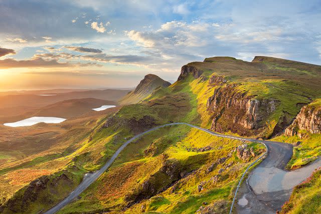
sara_winter/Getty Images
There’s a reason the Isle of Skye is highly popular among travelers: The views and landscapes are spectacular. While the island itself stretches 50 miles long and 25 miles wide, there’s a shorter — just under 4.25 miles — walking path that loops around to bring you back to where you started. The Quiraing is more than familiar with rough weather (clouds, rain, fog, wind, more rain), so walkers need to prepare for the natural elements, a relatively small price to pay for the overall experience on Skye. Rock formations, cliffs, and plateaus are photo-ready every step of the way, but hikers should be warned: This is no easy hike. It’s shorter than many treks across the U.K., but its difficulty level is on the higher end of the spectrum.
Glyndŵr's Way, Wales
Cymru Wales/Welsh Government
It’ll take nine full days of walking to complete the 135 miles of Glyndŵr's Way, although, like most National Trails, it can be traversed in a series of shorter sprints. Most people tend to walk the trail in the same direction: from Knighton to Welshpool. Named after the Prince of Wales and Medieval Welsh nationalist leader Owain Glyndŵr, the path goes through plenty of Welsh farmland and over numerous hills, with the heather-clad Pumlumon (the highest peak in the Cambrian Mountains) being one of the standouts along the route. Both spring and fall are popular times to complete the trail, with the wildflowers and autumnal leaves attracting many adventurers to the mid-region of the country.
Hadrian’s Wall Path, England
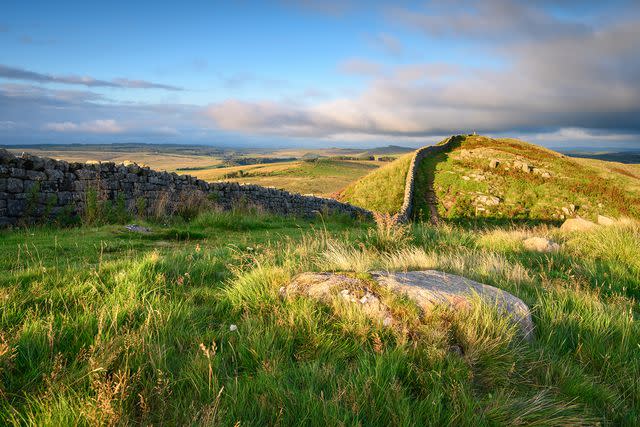
daverhead/Getty Images
Travelers in search of a trail that's both historic and relatively easy should look no further than Hadrian's Wall Path. Running from Wallsend, Newcastle upon Tyne, to Bowness-on-Solway in Cumbria, the trail follows the Roman defensive wall that was built in 122 A.D. and is now recognized as a UNESCO World Heritage Site. Most of the path is well-maintained, with a majority of the 84 miles winding through villages and remote countryside. The best time to walk Hadrian’s Wall Path is May through October, when the trail is less likely to succumb to wet weather and the ensuing mud. Walkers also have the option of starting on the east side, heading in the direction the wall was built, or on the west side, which is the recommended route for more favorite weather conditions.
Causeway Coast Way, County Antrim, Northern Ireland
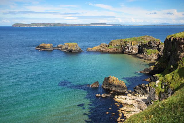
Courtesy of WalkNI
If you’re going to check off one walk from your list in Northern Ireland, let it be the mythical and dramatic Causeway Coast Way. Stretching between Ballycastle and Portstewart, the 31.5-mile path passes bays, beaches, and rocky cliffs, as well as tourist attractions like the Giant’s Causeway (as seen in Game of Thrones), Dunluce Castle, and Carrick-a-Rede Rope Bridge. The route, which is technically a section of the larger Ulster Way trail, takes between two and three days from start to finish; travelers who want more Northern Ireland adventures can also complete the Moyle Way and North Sperrins Way, which sit at either end of the Causeway Coast Way.
West Highland Way, the Highlands, Scotland
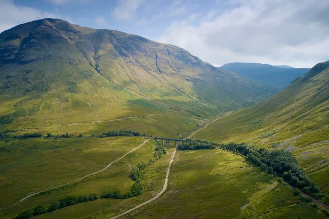
richard johnson/Getty Images
The West Highland Way runs from Milngavie to Fort William, with 96 miles of parks, moorland, lochs, and mountains along the way. Although the average length of the trip falls between six and eight days, many hikers recommend taking the walking trail at a leisurely pace in order to soak in the sheer beauty of the countryside. It’s the ideal walk for travelers who want to explore both the Scottish Lowlands and the Highlands; the route includes passing by Loch Lomond, Glen Coe, and Ben Nevis, the highest mountain in Scotland.
Wales Coast Path
Stefan Irvine/Getty Images
Welsh speakers also know the Wales Coast Path as Llwybr Arfordir Cymru, an 870-mile route that's generally walked in sections (versus the entirety of the path). It begins near Chester and ends in Chepstow, a town bordering Gloucestershire. Rugged and filled with all kinds of Welsh wildlife, the Wales Coast Path grants walkers unspoiled views of the country’s serene and often empty beaches. Worried about getting lost on a trail that long? Not to worry — the entire thing is waymarked with yellow and blue signage that also includes a very distinct dragon tail.
Slieve Binnian, County Down, Northern Ireland
Kevin Wells/Getty Images
Northern Ireland’s Mourne Mountains are home to Slieve Binnian, the third-highest mountain in the range that can be explored via a six- to seven-mile circular walk. When summiting the mountain, travelers reach 2,449 feet, which requires some careful climbing. Similar to most walks in the U.K., there are multiple ways to get around the Mourne Mountains, but this one in particular allows you to see panoramic views — and, in clear weather, the Isle of Man and Wicklow Mountains, which sit to the south of Dublin.
Pennine Way, England and Scotland
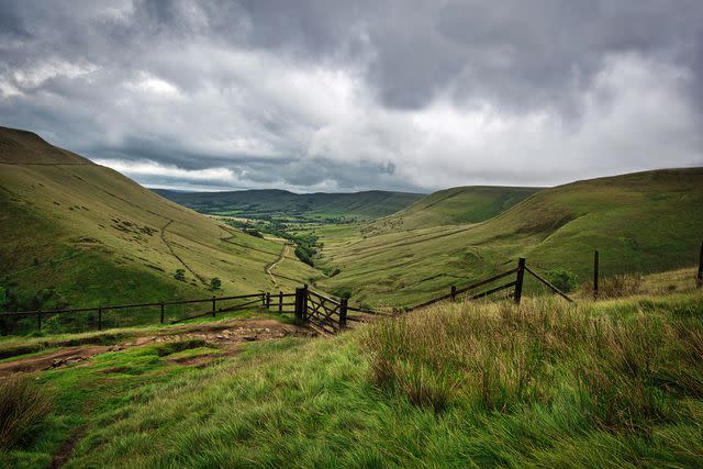
AlanMBarr/Getty Images
The first (and most challenging) National Trail in England, the Pennine Way is long — 268 miles, to be exact — hilly, and often remote. But it’s all worth it to take in some of the most incredible landscapes in the U.K., including the Peak District, Yorkshire Dales, North Pennines, Cheviots, and even Hadrian’s Wall. The route begins in Derbyshire and ends in Kirk Yetholm, a village in the Scottish Borders region, and it usually takes walkers around three weeks to complete. While long and strenuous, the Pennine Way can also be experienced by taking rest days at some of the larger towns along the way, like Hebden Bridge, Hawes, Alston, or Bellingham.
For more Travel & Leisure news, make sure to sign up for our newsletter!
Read the original article on Travel & Leisure.

