10 coolest summer getaways in Arizona: Mountains, lakes and a chilly cave trek
The essence of Arizona is remarkable diversity. The state can claim an unmatched combination of deserts and mountains.
High and low elevations in close proximity means that each season comes with options. When the heat becomes overpowering, just leave it behind for a weekend — or a week.
Find relief just a short road trip away. Cool off in pine forests and mountain meadows. Hike, swim, fish, camp or just relax and let time drift slowly past. You can have the summer of your dreams if you know where to look.
Here are 10 ideas for beating the heat in Arizona’s beautiful high country.
Arizona's best free attractions: 21 things to see and do that don't cost a cent
Hike Lava River Cave in Flagstaff
Come prepared with flashlights and ghost stories. This mile-long lava tube north of Flagstaff can be one of the chilliest summer hikes in Arizona, hovering around 42 degrees.
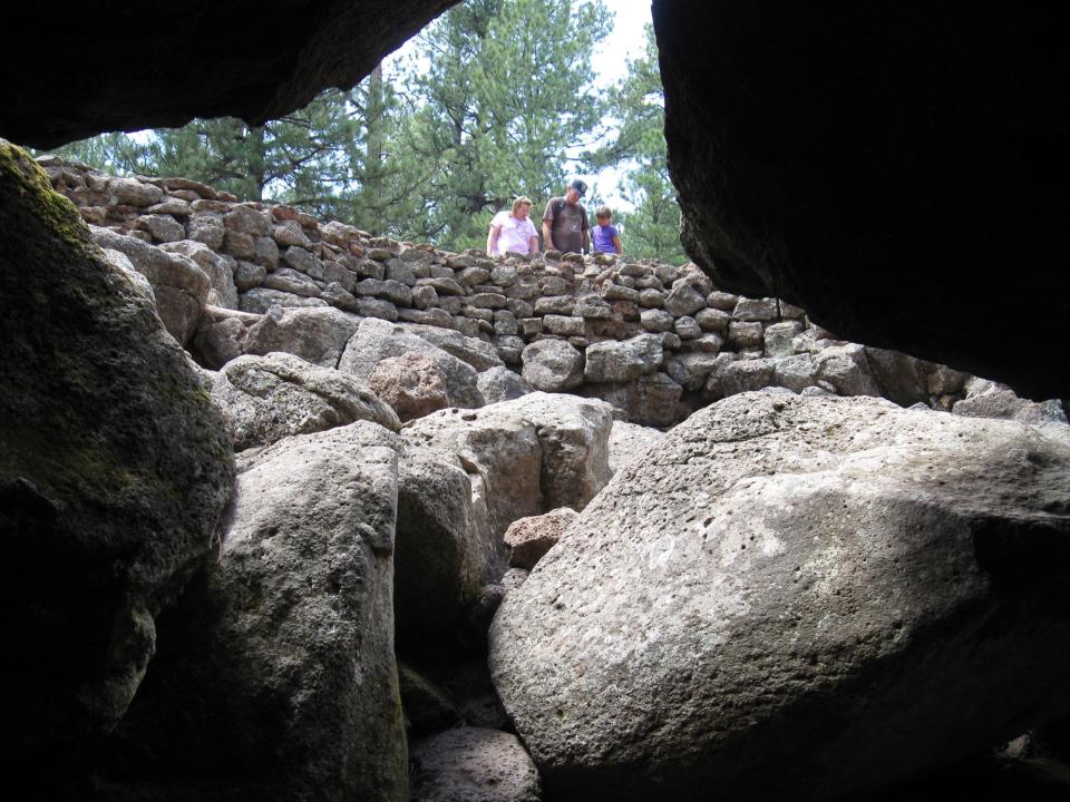
Formed 700,000 years ago by a river of molten rock blasted from a volcanic vent in nearby Hart Prairie, the cave is an ice cellar beneath the forest floor.
Carry at least two sources of light and watch your footing. After squeezing through a narrow opening, you’re able to walk upright the rest of the way, so you’ll have time spin tales of ghosts and giant spiders lurking in the darkness.
Details: Drive 9 miles north of Flagstaff on U.S. 180 and turn left on Forest Road 245 (at mile marker 230). Continue 3 miles and turn left on FR 171. Drive 1 mile and turn left on FR 171B to the parking lot. 928-527-3600, www.fs.usda.gov/coconino.
Stop and smell the flowers at the Arboretum at Flagstaff
If hiking a dark, chilly lava tube seems intimidating, try the soft shagginess of the Arboretum at Flagstaff. Tucked away down a dirt road on Flag’s west side, the arboretum is a botanical garden, nature center and environmental education station sheltered in a ponderosa pine forest.
Spread across 200 acres, the arboretum offers sun-kissed meadows and butterflies dancing among bright blooms. Plants spill from beds and crowd the pathways. The dozen themed gardens include forest meadow, pollinator garden, riparian habitat and shade garden. Peak blooms are June-September.
Details: 4001 S. Woody Mountain Road, Flagstaff. $12, $6 for ages 5-17. 928-774-1442, www.thearb.org.
Camp at the Grand Canyon's North Rim
You can reserve sites at the North Rim Campground within Grand Canyon National Park but it’s quite often full. If so, try DeMotte, a small campground in Kaibab National Forest, 7 miles from the park boundary.
Sitting at the edge of vast meadows at 8,700 feet and fringed by mixed conifer forest, DeMotte Campground offers 38 single-family sites for tents and RVs (no hookups). It’s a great place for wildlife sightings. Half the sites are available on a first-come, first-served basis, and the other half can be reserved.
Details: From Jacob Lake, drive 25 miles south on State Route. $26 per night. 877-444-6777, https://www.recreation.gov.
Take a walk: 7 easy hikes at the Grand Canyon, plus 3 not-too-difficult ones that go below the rim
Splash in a cool mountain stream near Payson
Tonto Natural Bridge State Park, northwest of Payson, shelters the largest natural travertine bridge in the world. The Pine Creek Trail slips down through the woods to join the slender waterway that carved the mighty bridge. From there just work your way downstream, around boulders and past a series of pools.
The splashy music of cascades and mini-falls echoes through the trees. Look for small caves and alcoves along the bank. Arrows painted on rocks lead the way. The trail ends at the cavernous 400-foot-long tunnel beneath the bridge. Return the way you came or climb out via the short but steep Anna Mae Trail. Swimming is permitted downstream from the bridge.
Details: The park is 10 miles north of Payson off State Route 87. $7 per person, $4 for ages 7-13. 928-476-4202, https://azstateparks.com/tonto.
Cozy up in a waterfront cabin in Greer
Greer Lodge Resort & Cabins offers a sweet getaway for anglers, with all cabins on or near the water. Guests just have to choose whether they want a cabin on the small trout ponds or on the Little Colorado River.
But you don't have to fish to enjoy the property. Built in 1948, Greer Lodge borders national forest and includes a play area, basketball and volleyball courts and horseshoe pits. Watch for deer and elk grazing the meadows. They offer 20 well-appointed log cabins. The largest can sleep 12. Several are dog friendly.
Details: 80 Main St., Greer. Cabins start at $129 per night; check the website for specials. 928-735-2304, www.greerlodgeaz.com.
Ride a gondola to the top of the San Francisco Peaks
What a ski season it’s been at Arizona Snowbowl north of Flagstaff, going until May 29. Just a few weeks later, the scenic Arizona Gondola skyride began making its daily journeys up to the mountaintop.
Marvel at the vistas spilling away in all directions as you glide up the slopes before being deposited at 11,500 feet. Pause to enjoy incredible panoramas, the sweet chilled mountain air, and some memorable photo opportunities before returning. You may not be on the roof of Arizona but you’re pretty darned close.
Details: 9300 N. Snowbowl Road, Flagstaff. Gondola tickets start at $18 when you buy online in advance. https://www.snowbowl.ski.
Drive up the highest mountain in southern Arizona
Travel through five life zones on this twisting climb up the slopes of Mount Graham, southern Arizona’s highest peak. For 35 miles State Route 366 makes a switchbacking ascent from desert scrubland to high forests. The last 12 miles are a narrow winding gravel road. (You may be more comfortable in a high-clearance vehicle.)
You’ll climb past creeks, picnic areas and campgrounds. Ladybug Saddle is named for the large number of the colorful beetles that gather during summer. A wildflower-carpeted alpine meadow known as Hospital Flat (once used by recuperating soldiers from Camp Grant) makes a peaceful rest break.
The road ends near one of the prettiest high-country lakes you’ll find. Shimmering Riggs Flat Lake is ringed by pine and fir trees at 9,000 feet.
Details: From Safford, drive south on U.S. 191 for 8 miles and turn west on State Route 366. 928-428-4150, www.fs.usda.gov/coronado.
A summer's worth of adventure awaits at Lyman Lake State Park
At 1,500 acres, Lyman Lake dwarfs all bodies of water in the White Mountains. With such an expanse, there are activities for everybody, including a sheltered swimming beach, a no-wake zone for anglers, twisting canyons kayakers will love and plenty of wide-open water for speed-boaters and skiers.
A small store sells food, bait and supplies. Anglers can catch largemouth bass, catfish, carp and walleye. The campground overlooks the lake, featuring 56 sites, 38 with electric and water hookups. The park also eight eight air-conditioned cabins with full-sized beds, bunk beds, table, chairs and covered porch.
Details: The park is 19 miles north of Springerville in eastern Arizona. It's about 235 miles from central Phoenix. Day use is $10 per vehicle. 928-337-4441, https://azstateparks.com/lyman-lake.
Visit Hawley Lake, the coldest place in Arizona
Surrounded by mountain peaks, Hawley Lake is tucked away on White Mountain Apache tribal Land. Hawley gained notoriety for having the coldest temperature ever recorded in Arizona, 40 degrees below 0 in January 1971.
The 300-acre lake is an angler's playground filled with rainbow, brook, brown and cutthroat trout. You need a permit to fish on tribal land. Go to https://wmatoutdoor.org for info. The lake offers camping, a lodge, cabins and boat rentals.
Details: Hawley Lake is on State Route 473 in the White Mountains southeast of McNary. It's about 205 miles from central Phoenix. 928-369-1753, www.wmat.nsn.us/hawleycabins.
Drive south for high-elevation hiking at Chiricahua National Monument
Instead of going north, dodge some traffic by driving south to Chiricahua National Monument. Forming an island of sculpted stone and forest in a sea of arid grasslands, the 12,000-acre park southeast of Willcox shelters an exotic array of massive columns, slender spires and impossibly balanced boulders.
The craggy skyline seems to be built from the splintered remains of ancient castles. Elevation at Chiricahua National Monument ranges from 5,124 feet at the entrance station to 7,310 feet at the top of Sugarloaf Mountain.
A shady campground is tucked amid the oaks and pines of Bonita Canyon. Miles of hiking trails weave their way through the otherworldly rock formations. And tours of Faraway Ranch, a homestead from the 1880s, are conducted when staffing permits.
Details: From Willcox, drive south on State Route 186 for 32 miles. Turn left on SR 181 and continue 4 miles to the park. Free. 520-824-3560, www.nps.gov/chir.
Meet Roger Naylor, get summer travel tips
Roger Naylor will be in metro Phoenix on July 25 to talk about his latest book, "Awesome Arizona: 200 Amazing Facts About the Grand Canyon State." There will be a slide presentation with travel tips, and Naylor will answer questions and sign copies of his book ($16.95). And there will be coffee and pastries.
Details: 7 p.m. Tuesday, July 25. Georgia T. Lord Library, 1900 N. Civic Square, Goodyear. Free. https://mcldaz.org/en-US/georgia-t-lord.
Find the reporter at www.rogernaylor.com. Or follow him on Facebook at www.facebook.com/RogerNaylorinAZ or Twitter @AZRogerNaylor.
This article originally appeared on Arizona Republic: Coolest summer getaways in Arizona: Grand Canyon, Flagstaff, 8 more

