onX Offroad Maps Now Show Trail Difficulty and Terrain Types
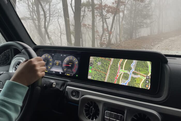
OnX Offroad continues to build out and upgrade its impressive mapping software. Its latest update brings with it a color-coded Guided Trails Rating System, eight distinct terrain classifications, and some refined points of interest icons.
“We’re really proud of these new features that we have launched, they enhance user safety as well as the overall experience. This is just the start of what we have planned to enhance the user interface. We are always striving to ensure onX Offroad maintains our position as the industry leader for planning off-road adventures.”
— Rory Edwards, General Manager for onX Offroad
onX Offroad Guided Trails Rating System

The new Guided Trails Rating System is a color-coded, four-tiered rating scale. The idea is to be able to tell how difficult trails are with just a glance at the map.
The Guided Trails Rating System looks like this:
Green Trails: Easy
Blue Trails: Moderate
Black Trails: Difficult
Red Trails: Extreme
The ratings themselves will be managed by the onX Offroad Trail Guides program. These are off-road enthusiasts who are working closely with onX Offroad to map, rate, classify, and create detailed information about trails all across the globe. This system also ensures that the rating scale will be updated on a regular basis. This feature will only be available to paid subscribers.
onX Offroad Terrain Classifications

Also with this latest update to the onX Offroad software, both mobile and desktop, we get eight distinct terrain classifications. This new classification system lets you know what type of terrain to expect on the trail, which can be helpful when planning recovery gear and setting tire pressures.
8 Terrain Classifications
Slick Rock
Forest
Alpine
Prairie
Rock Crawl
Desert
Sand Dunes
Mud
Latest onX Offroad Updates

Also in this round of updates are refined points of interest icons. OnX Offroad says, “The new bold and clean design makes them easier to read at a quick glance.” This makes planning so much quicker, before a trip and while on a trip, so as not to miss interesting POIs.
onX Offroad is a robust mapping system that I’ve used all across North America, when traveling on both two wheels and four. I generally use Google Maps for broader picture things, and then use onX Offroad to dial in the details and learn about the trails/terrain.
Get the lowdown on all things onX Offroad.
The post onX Offroad Maps Now Show Trail Difficulty and Terrain Types appeared first on GearJunkie.

