The best satellite messengers in 2024, tried and tested
Content is created by CNN Underscored’s team of editors who work independently from the CNN newsroom. When you buy through links on our site, CNN and its syndication partners may earn a commission. Learn more
Leaving behind the hustle and bustle of civilization is a major reason why hiking and camping excursions are so enjoyable, but if something goes wrong, that isolation can become a real liability. Cell phones aren’t much use in secluded parks and backcountry wilderness, so if you snap an ankle, get lost on a hiking trail or find yourself needing to make contact with the outside world for help, these issues can quickly become life-threatening. Luckily, satellite messengers don’t rely on local towers to communicate, and as long as you’re outside with a clear view of the sky, they can transmit and receive messages from practically anywhere.
Though they don’t provide voice communication like a satellite phone, satellite messengers include an SOS button that broadcasts your location to rescue personnel, and many feature two-way communication so you can text or email with friends and family as well as share your location as you go. They’re not cheap, and all require a monthly satellite subscription, but if you end up needing it, a satellite messenger is well worth the cost.
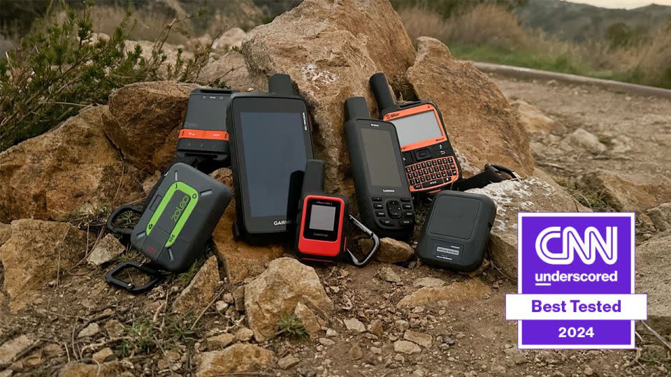
Satellite messengers can vary when it comes to functionality, price and portability, so we field-tested seven of the most popular options to find the best. This testing involved evaluating their overall usability, comparing communication and navigational features while hiking in cell phone dead zones and researching satellite and emergency response procedures. After comparing this data, we landed on the Garmin inReach Mini 2 as the best satellite messenger.
Garmin inReach Mini 2
Best satellite messenger

Compact, durable, remarkably easy to use and supported by Iridium’s global satellite network, the Garmin inReach Mini 2 is a reliable device that’s worth the investment.
The best satellite messenger: Garmin inReach Mini 2
$400 $356 at Amazon or $400 at REI and Garmin
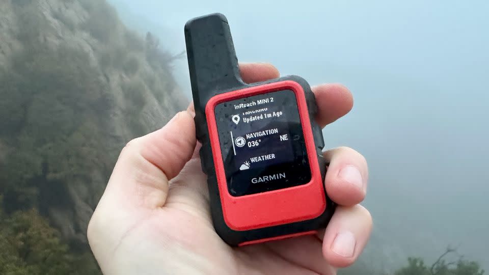
Boasting an intuitive interface, reliable satellite connection and a convenient compact size, the Garmin inReach Mini 2 was the best satellite messenger I tested. The newest model in Garmin’s inReach Mini lineup, this sturdy little device really nails that sweet spot between functionality and usability, packing a ton of features into an easy-to-use package.
This overall ease of use was one of the biggest takeaways from my testing, and unlike with every other device in my testing pool, I didn’t need to consult the instruction manual to figure it out (always a big plus with emergency equipment). Not only are the menus, submenus and settings convenient to navigate but the ergonomics of the controls — two buttons on either side — allow it to be used one-handed. It operates with a responsive, snappy speed, and I didn’t experience any lagging or delays during my testing.
When it comes to nonemergency messaging, the Garmin inReach Mini 2 offers two-way text, email and a check-in feature, all of which include a link to your location. Despite the small screen size, the bright and crisp display makes it easy to read and scroll through these messages, although the actual typing process is a bit time-consuming. This is less of an issue thanks to the Garmin Messenger App on your smartphone, which pairs with your inReach and provides a much more convenient typing platform. If you don’t want to rely on a separate device for quick messages, you can also create up to 14 pre-typed messages, which can be edited on the Garmin Explore desktop site before you leave for your trip. If hassle-free typing is your top priority overall, the physical QWERTY keyboard of the Spot X 2-Way or touchscreen of the Garmin Montana 750i would be a better option.
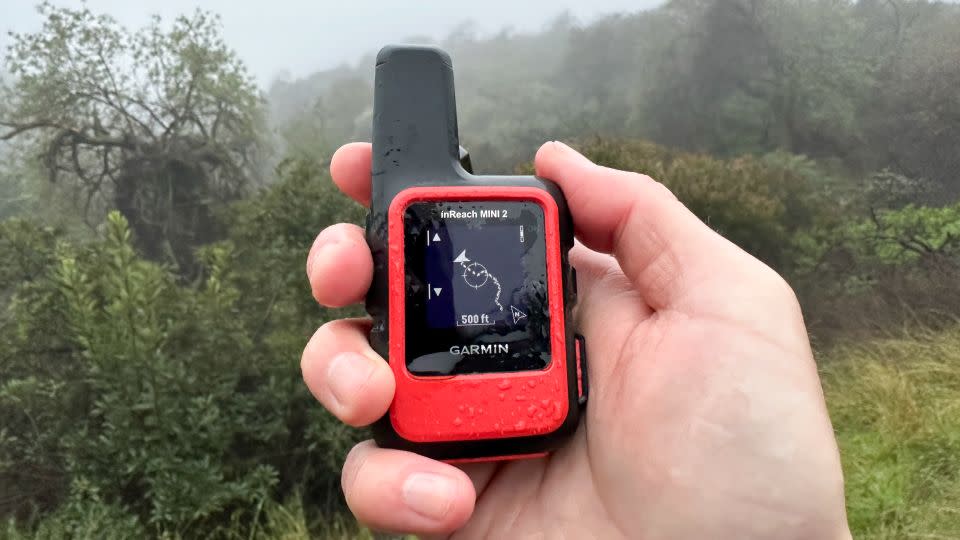
The Garmin inReach Mini 2 also has a useful tracking feature that’s simple to turn on and off, as well as different interval ranges (closer intervals translate to lower battery usage, though). You can also share your tracking with others by sending a mapshare link — prompted by the unit when activating tracking — which allows others to monitor your journey back at home. You also can watch this tracking route in real-time on the screen of the Garmin inReach Mini 2, which shows the location of any waypoints or sent messages along the path. It’s important to note that this is simply a dark line on a blank background, and the Garmin inReach Mini 2 does not provide any maps to place your route on top of. This obviously limits its navigational capability, but this basic visual representation of your route is still useful for compass direction, backtracking, eyeballing distance (a distance guide adjusts as you zoom in and out) and providing distance and altitude specs to view later on. For map-based navigation, check out the Garmin Montana 750i or Garmin GPSMAP 67i, both of which feature topographic and road-based maps.
Like all Garmin devices, the Garmin inReach Mini 2 uses the Iridium satellite network for its messaging and SOS functions. This network is not only the largest commercial satellite company in the world but it’s the only one that provides true global coverage — even in polar regions. I wasn’t able to test the SOS button myself, but it sits underneath a sturdy removable cover, and when activated, immediately alerts Garmin’s 24/7 response center. A dispatcher then uses your location to determine the proper authorities to contact and relays your location for rescue. The response center also sends confirmation back to your device that rescue is underway, and depending on the scenario, it allows two-way communication with your rescuers to provide more information on your specific situation.
The Garmin inReach Mini 2 offers a range of subscription plans, all of which include an activation fee ($30 for annual plans and $35 for freedom plans that you can suspend after 30 days). These plans run from $11 to $15 per month (yearly versus monthly plans) for the Safety Plan with a limit of 10 text messages, $25 to $35 for the Recreation Plan (40-message limit), and $50 to $65 for the Expedition Plan (unlimited messages, as well as two-minute tracking intervals versus the 10-minute intervals on other plans).
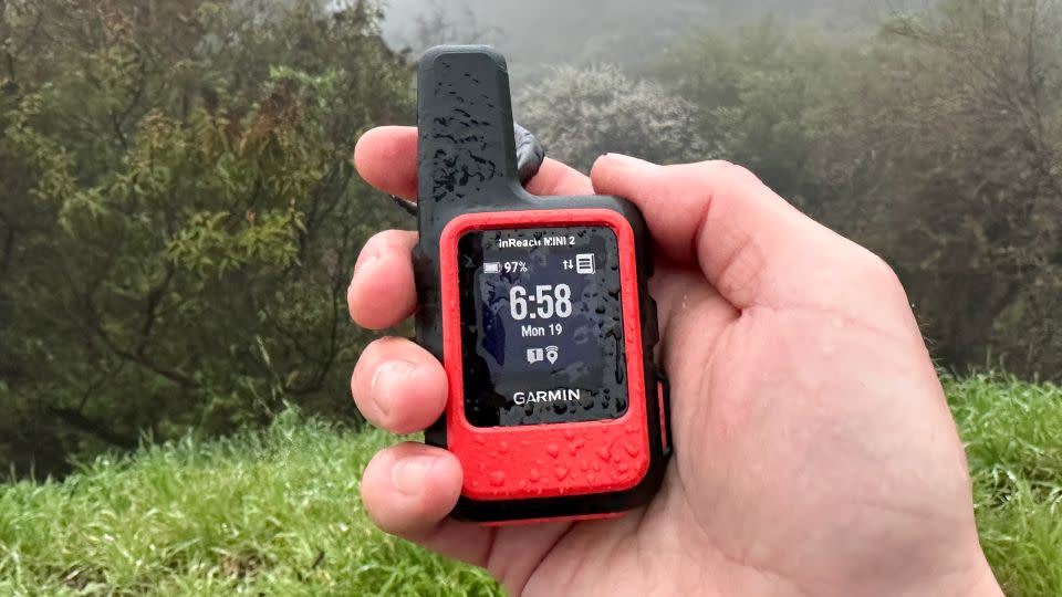
In terms of durability, the Garmin inReach Mini 2 is about as rugged as they come, and its stocky frame is covered in a heavy-duty, dense rubber covering. Although I wasn’t able to fully test the 3-foot depth of its IPX7 waterproof rating, it survived a 30-minute submersion in my bathtub without any issues. I’m also a big fan of the swiveling carabiner strap, which allows you to rotate and read the screen without unhooking the device from your belt loop or backpack strap. Even after I took a decent tumble down a rocky trail with the Garmin inReach Mini 2 clipped to my belt loop, I couldn’t even find a scratch on it.
If you’re looking for a unit that’s supported by a reputable satellite network, is simple to use after a few minutes of practice and includes a useful variety of features, you’re not going to find a better option than the Garmin inReach Mini 2.
How we tested
Satellite messengers can be pretty complicated — especially if you’re not technologically proficient — and choosing the right one for you can be an intimidating task. To better differentiate between options and ultimately choose the best model, I created and implemented a comprehensive testing and evaluation process.
Usability
Operation: Since a satellite messenger may be used infrequently, outdoors and potentially in an emergency situation where time is critical, it’s important that they’re easy to use. To properly judge each device’s overall ease of use, I explored each one’s available functions and features, noting how simple or complicated their controls, display and overall interface were to use.
App: I compared each brand’s accompanying smartphone app, noting if they were helpful and if their features could still be used with satellite connection (and without Wi-Fi). Each device’s desktop portals were examined as well, and I noted whether or not they displayed my tracking and routes accurately and effectively, or were buggy and frustrating to operate.
Instructions: I performed this test first without consulting the manual at all, just to give a rough idea of how a first-timer might run into any issues. Then I sat down and thoroughly reviewed the manual and any videos or tutorials I needed.
Performance
Messaging: I took each unit to a large, mountainous park — focusing on the trails and areas notorious for their lack of cell coverage — and used all available messaging features, such as texting, email, check-in and location sharing with a partner back home.
Navigation: I utilized any navigational features (both driving toward and into the park) like trail directions, map waypoints, compass and backtracking elements.
Display: I paid close attention to how well each unit’s display functioned in the field, noting if the screens and selection responses were laggy or quick and how easy the screens were to read in different sunlight conditions.
Battery: I measured how long it took for each units’ battery to drain (with tracking intervals set up as close to one another as possible) as well as how long it took to charge from zero to 100%.
Portability
Size and weight: I evaluated each device’s overall portability and noted if they included helpful straps or carabiners to attach to my pack or belt loop. I also compared their overall size and weight, and if any added functionality was a worthy compromise.
Construction
Durability: I did my best to compare each units overall durability, examing their screens, body and carabiner straps for any potential issues down the line. I also tested any advertised water-resistance ratings by submerging the devices in my bathtub.
Emergency capability
SOS feature: Though I wasn’t able to fully test each unit’s SOS feature, I did research each manufacturer’s specific emergency response protocols in the event the SOS button was pressed. I also found as many firsthand accounts of users who actually activated their SOS button on backcountry and hiking message boards, forums and reviews to get an idea of what actually happens from activation to rescue.
Satellite reliability: I researched the specific satellite network used by each brand I tested, which revealed valuable differences in coverage areas, as well as potential legal issues for bringing satellite messengers into certain countries.
How does a satellite messenger work?
Unlike cellular phones that communicate by sending and receiving their signal to a nearby cell tower, satellite messengers transmit their signal directly to a low Earth orbit (LOE) satellite 485 miles above the Earth’s surface. Since a commercial satellite is much higher than a land-based cell tower — although much lower than a government satellite — it’s able to provide much better visibility, even in remote areas. By using an orbiting network, or constellation, of these satellites, their overlapping paths create a global (or near global, depending on the company) coverage blanket.
While this satellite connection is invaluable while traveling off the grid, it’s not as easy as pushing a button on a cell phone. Satellite messengers typically must be used outdoors, or at least through a window, and pointed at the sky to transmit and receive properly. Even minimal interference between the antenna and satellite can affect the connection.
It’s worth noting that different brands of satellite messengers can use different satellite constellations, the two most popular being Iridium (used by Garmin) and Globalstar (used by Spot, as well as the iPhone’s SOS function). The main difference is that Garmin’s Iridium constellation uses 66 satellites — allowing it to maintain total global coverage, even at the Earth’s poles. Globalstar’s 24 satellites lack coverage in parts of Asia and Africa.
When the SOS feature on a satellite communicator is activated (almost all devices have a clearly labeled SOS button protected by a cover to prevent accidental activation), the signal is routed from the satellite directly to the response center of that specific device brand. A dispatcher then uses your location to alert the proper authorities, who then activate the appropriate search-and-rescue response. Depending on your device’s capabilities, this dispatcher will send confirmation that your SOS has been received, gather additional information on your emergency and connect you with rescuers for two-way communication. Keep in mind that depending on your location, the weather and other factors, a rescue team can still take a considerable amount of time to reach you.
What to look for in a satellite messenger
In addition to the SOS feature found on all models, satellite messengers can offer a range of other functions and capabilities. To ensure that you end up with the best option possible, and prevent you from spending extra money on bells and whistles you don’t need, take some time to really think about which features would be most useful for you and your trip.
If you’re interested in maintaining nonemergency contact with friends or family back home, look for check-in (just a basic “I’m OK” sent with a single push of a button), text and email messaging, as well as location-sharing features. While most devices include a link to your location with every message sent, some also have their own dedicated map portals that allow others to follow your route in nearly real time.
Many devices also include some degree of navigational capability, which can range from simple compass directions leading toward a set of coordinates to comprehensive map-based navigation, similar to what your smartphone offers. These features tend to increase the upfront cost of the unit and decrease battery run time, but if you’re venturing into unfamiliar terrain, or just want to make sure you don’t get lost, they could certainly be worth the cost. Plus, by preventing you from getting lost or turned around, these features could ultimately save you from needing to use the SOS function at all.
The ability to retrieve weather forecasts is another valuable feature to consider. Almost all satellite messengers with display screens provide some kind of weather forecast option, which can prevent you from inadvertently continuing your trek into an unexpected storm, cold front or heat wave.
Your travel destination should also be taken into consideration since not all satellite messengers offer global coverage. As noted, the Iridium satellite network, for example, offers complete global coverage, while the GlobalStar network lacks service in some parts of Asia and Africa, as well as the polar caps. Some countries don’t allow satellite messengers altogether, so make sure to double-check before departing to prevent any legal issues.
Do I need a satellite messenger if I have an iPhone 14?
If you aren’t interested or able to purchase a satellite messenger, you may already have one in your pocket. iPhone 14, iPhone 14 Pro, iPhone 15 and iPhone 15 Pro smartphones now include an emergency SOS satellite messaging feature. If you attempt to dial 911 outside of cell service, the phone will prompt you to text via its satellite connection (free for the first two years of service), which then guides you through the steps needed to contact emergency services. You can then text with responders, who also have access to your location, the battery level of your phone, as well as your emergency contacts.
The drawback to using an iPhone 14 as your satellite communicator as opposed to a dedicated option is that you’re limited to only SOS contact, as this satellite communication cannot be used for regular texting or any navigational features. They also use the Globalstar satellite network, which has less coverage than Garmin’s global Iridium network. iPhones are also much less durable than satellite messengers and very susceptible to water damage.
Is a satellite messenger worth the price?
They’re not exactly cheap, but if you’re planning on venturing into remote areas away from cell phone coverage, then yes, a satellite messenger is worth the price. If you or someone in your party becomes injured, sick or lost while away from cell service, the ability to reliably contact authorities could be the difference between life and death.
In addition to the upfront cost of the device, all satellite messengers also require a subscription to activate and maintain satellite contact. This subscription price can vary since all models offer different pricing tiers, which allows you to choose the option best suited to your budget. It’s important to note that these lower-cost tiers only limit messaging, tracking and weather forecast functionality; they don’t affect the SOS function at all.
While I would never want to dissuade someone from utilizing an SOS beacon for fear of the financial repercussions, it’s important to keep in mind that any costs associated with your rescue are your responsibility. Depending on your location, the nature of your emergency and the resources required to locate and extract you, a rescue can leave you with a very large bill at the end of the day. It’s not always clear how this can shake out, as some areas (like national parks) may not charge for a helicopter evacuation, for example, but a subsequent ambulance ride to the hospital now falls under your responsibility. That being said, the navigation and weather forecast features of an expensive satellite messenger can potentially prevent you from needing a rescue in the first place, which in itself is worth the investment in my opinion.
If you’re concerned about the potential financial issues involved with a rescue, Garmin offers Search and Rescue Insurance with active inReach subscriptions. This plan includes up to $100,000 in reimbursement of covered rescue costs, for $40 per year.
Other satellite messengers we tested
Garmin Montana 750i
$800 $721 on Amazon
This beefy machine is packed with bells and whistles, and features a massive 5-inch color touchscreen. Although this screen blew away the competition in terms of map readability and navigation — the touchscreen controls and pinch-to-zoom capabilities are similar to those on a smartphone map — it’s also the cause of its limited run time. It lasted around 15 hours when set to 10-minute tracking, as well as several hours of map navigation and the occasional two-way message, which roughly lines up with Garmin’s 18-hour claim. This run time was by far the shortest of all the units I tested, but the Montana does offer an optional Expedition mode (a low-power mode that tracks in 30-minute increments) that allows for roughly two weeks of battery life.
In terms of functionality, the Garmin Montana 750i provides a huge amount of navigation (including TopoActive maps as well as CityNavigator driving maps), messaging (made much more convenient with the touchscreen) and weather features (basic, extended or marine forecasts), as well as the reliable Iridium satellite network used with all Garmin devices. If you have the budget, the need for a wide variety of functions and don’t mind the shorter run time, this is an awesome tool.
Garmin GPSMAP 67i
$600 on Amazon
If you can’t justify the price and size of the Garmin Montana 750i, and the Garmin inReach Mini 2 lacks the functionality you’re looking for, the Garmin GPSMAP 67i offers a nice balance between the two. You’re still getting a color display, TopoActive maps — which include existing trails and roads, as well as icons for useful points of interest (POIs) like water sources, trailheads and restrooms — as well as a battery run time that can last up to 14 days if used sparingly. During my testing, I cranked the tracking interval up to every two minutes (probably overkill for most people), used it for several consecutive hours of navigation and map use, and sent occasional two-way messages, and it still lasted four days before needing to recharge, which is comparable to the Garmin inReach Mini 2’s 3.5-day run time for the same operation. The 240 x 400 vertical display is a far cry from the Garmin Montana 750i’s 480 x 800 screen, but it’s still crisp and clear enough to read without issue.
The rubber control buttons have a beefy, sturdy feel to them, and the directional arrows and zoom controls make it easier than expected to move around and select locations on the map. I especially appreciate that once your destination is selected, the Garmin 67i asks if you prefer to adjust your route based on minimizing time, ascent or distance. I was also a big fan of the dedicated waypoint button on the control panel, which I found much more convenient than having to access it via multiple steps, like every other model I tested.
This directional pad also helps make typing a bit easier than the up and down arrows of the Garmin inReach Mini 2, and connection to the Garmin Messenger app is an easy solution for those who want to do a lot of typing quickly. The overall ease of use, navigational features and long battery run time make this unit a fantastic choice for those who want more bells and whistles than the Garmin inReach Mini 2 has to offer.
Garmin inReach Messenger
$300 on Amazon
Despite its compact size (less than 1-inch thick) and a tiny, 1-by-0.5-inch display, the Garmin inReach Messenger provides an impressive amount of functionality. Similar to the Garmin inReach Mini 2, this device does its best to make up for the limited screen size with helpful prompts, allowing you to quickly maneuver through the different functions, and return to the menu screen, without getting lost or frustrated. The 160 x 68 screen also does a decent job of displaying messages, menu icons and even weather forecasts. Typing messages with its three-button control interface can be a bit of a slog; though, with 14 preset messages and the accompanying Garmin Messenger app, that’s less of an issue.
Tracking is simple to set up and share with friends while you’re on your journey, and you can even backtrack to a previous set point if you get turned around (although with no maps, you’re simply following a compass arrow). Its tough rubber exterior gives this device a really durable, sturdy feel, and after a few accidental drops on a rocky trail, it showed no damage. It also uses Garmin’s Iridium satellite network, which provides 24/7 response to an SOS activation, dispatching the local authorities to your location. You’re also able to receive confirmation that your SOS has been received and maintain two-way contact with rescuers if needed.
Spot X 2-Way
$250 on Amazon
Thanks to a Blackberry-style QWERTY keyboard, physical buttons and a large display, the Spot X Two-Way satellite messenger was the easiest device to use during my testing. An Enter button surrounded by four directional keys makes it a breeze to navigate and select menu icons, as well as quickly scroll through message and navigation input fields. Sure, the keyboard keys are small but typing with a physical keyboard is still much faster than going letter by letter like other non-touchscreen devices such as the Garmin inReach Mini 2, Garmin inReach Messenger and Garmin GPSMAP 67i. You can also forgo the keyboard altogether by selecting one of the 14 preset messages (you can edit these on the Spot website). Its tracking feature also gives others a nearly real-time view of your route on the Spot Share map page online.
The Spot X Two-Way also provides a rudimentary navigation function, using a digital compass to guide you toward a previously set waypoint (or you can input exact coordinates). Like the Spot Gen 4, the Spot X Two-Way uses GlobalStar satellite network, which lacks the total global coverage of Garmin’s Iridium satellite network. Despite lacking in the navigation department, this model would still be a fine option for anyone interested in quick-and-easy messaging and who doesn’t want to rely on a phone app to do so. Plus, given the relatively low upfront price tag (the subscription fees are comparable to Garmin’s) you’re getting a lot of functionality for the price.
Spot Gen 4
$149 on Amazon
This affordable, no-frills satellite messenger doesn’t have the bells and whistles of other devices, but its minimal design makes it a useful option for those who are only interested in the basics. It includes the standard SOS button underneath a protective cover, as well as a unique Spot ASSIST button that sends a message to any preset contacts that you need help (for situations that may not qualify as life-threatening but you still want to quickly send your location to friends or family). Three large buttons on the front control the nonemergency functions: check-in, custom message and tracking, all of which include a link to your current location. Check-in and custom messages can be prewritten on your Spot account online (110 characters each), which is also where you adjust the tracking intervals. I was impressed with Spot’s online map account, which allows you to review your route when you’re back in civilization and others to watch in real-time while you’re gone. With no display, you need to rely on the GPS and Message LEDs to indicate whether or not your message has been sent.
Spot devices use GlobalStar satellite network, which lacks the global coverage of Garmin’s Iridium network. This can be an issue if you’re venturing into certain areas of Asia and Africa, so make sure to check before purchasing this device. Also, since this unit only offers one-way communication — all our other models offer two-way messaging — you won’t be able to communicate with the dispatcher or rescuers.
Zoelo Satellite Communicator
$199 on Amazon
What’s nice about the Zoleo is that you can use it as either a standalone device or paired with a smartphone for additional features. On its own, the two-button interface provides two basic functions — an SOS beacon or a pre-edited check-in message — and a tracking feature that allows others to track your progress back home. By using it in tandem with the Zoleo app — which essentially acts as a separate display — you can also use your smartphone to send and receive text or email messages (upon setup, Zoleo assigns a phone number and email address, which others can use to send messages). This app also allows you to adjust tracking intervals, show weather updates, provide a map of your location and other info like battery level. The Zoleo also uses the same Iridium satellite network that Garmin does, ensuring you have complete global coverage wherever you are on the planet.
This unit is also built for durability, with a thick rubber case, strong covers over the charging port and SOS button, and an impressive IP68 waterproof rating. This rating allows for submersion in up to 2 meters of water for 30 minutes, which is marginally better than the 1-meter depth of Garmin’s IPX7 rating. I appreciate its relatively low $200 price tag (although for $50 more the Spot X provides a fully functional screen and keyboard), and depending on which of the three subscription plans you choose, the monthly cost is similar to other devices. This limited messaging functionality — and dependence on a separate smartphone for texting and emails — ultimately kept the Zoleo out of our top spot, but it’s still a fine option for a traveler whose main priorities are durability and global reliability.
Note: The prices above reflect the retailers' listed price at the time of publication.
For more CNN news and newsletters create an account at CNN.com

