Wind, hail and tornadoes possible Thursday afternoon in Tuscaloosa
Severe weather on Thursday could bring heavy rain, damaging winds up to 70 miles per hour, quarter-sized hail and the possibility of tornadoes to the Tuscaloosa area, according to the National Weather Service in Birmingham.
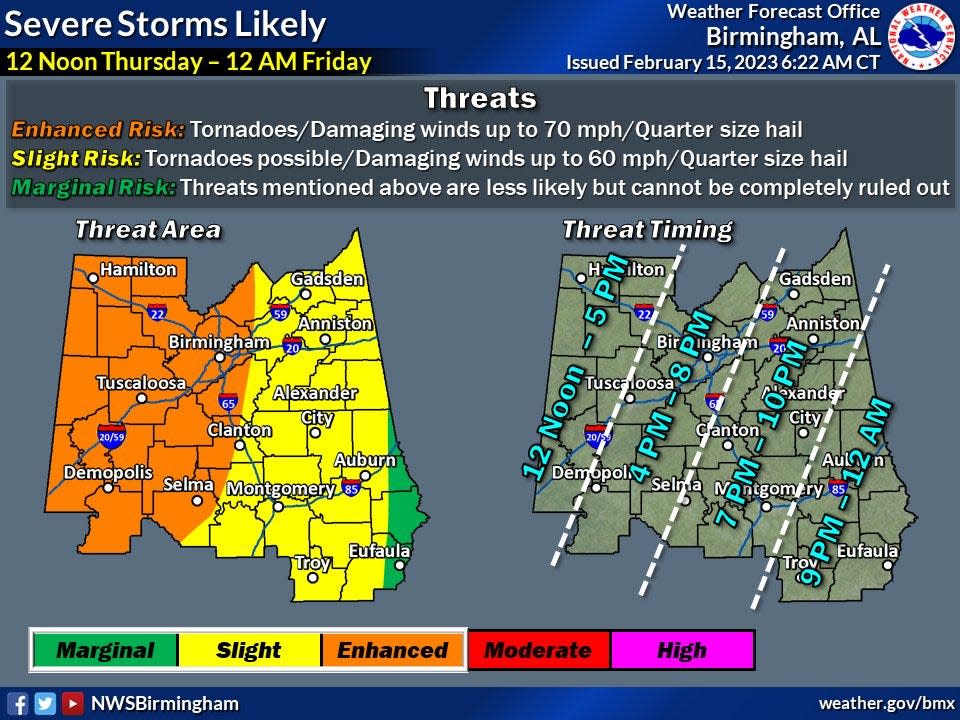
A powerful cold front will put the entire state under the threat of severe weather Thursday afternoon and evening.
Nathan Owen, a meteorologist for the National Weather Service in Birmingham, said Tuscaloosa area residents can expect the risk of severe weather to begin around noon and last until 5 p.m. Thursday.
Owen said the biggest concern for Thursday will be the development of supercell storms, which could possibly produce tornadoes.
Now is the time to prepare and come up with a safety plan, Owen said.
"Where are you going to be tomorrow? And if a warning is issued, where would you take shelter if something were to happen... Have a plan in place now before the storms get there. So that if a warning is issued tomorrow, people will know what to do at that point," Owen said.
Staying weather aware is also another way to keep safe during Thursday's storms through television, radio, online and trusted sites on social media.
"Make sure you have multiple ways to receive alerts throughout the day, especially through those afternoon hours. So whenever severe storms start to develop and we issue warnings ... you're able to get it as quickly as possible to take action," Owen said.
More:Tuscaloosa EMA website eases access to information, updates
For weather updates, residents can also follow the Tuscaloosa Emergency Management Agency on Twitter at @TuscaloosaCoEMA; The National Weather Service in Birmingham's account at @NWSBirmingham; and the Alabama Emergency Management Agency's account at @AlabamaEMA.
The Tuscaloosa County Emergency Management Agency has a list of storm shelters at www.tuscaloosacountyema.org/storm-shelters. Residents can also sign up to get weather alerts from the Tuscaloosa EMA on their phone by signing up for TuscAlert. A link to sign up for TuscAlert is provided at www.tuscaloosacountyema.org.
Schools to dismiss early
Tuscaloosa city and county schools will close early on Thursday because of the severe weather threat.
All students in the Tuscaloosa County School System will be dismissed at 12:30 p.m.
Tuscaloosa City Schools' students in the elementary schools, the Tuscaloosa magnet schools and the Alberta School of Performing Arts will be dismissed at 11:30 a.m. At noon, the middle schools will be dismissed, followed by the high schools and the S.T.A.R.S. Academy at 12:30 p.m. Meals and transportation will be provided as part of the early dismissal.
Shelton State Community College also announced the 10 a.m. dismissal of its classes. The University of Alabama will suspend operations at 12:30 p.m.
This article originally appeared on The Tuscaloosa News: Wind, hail and tornadoes possible Thursday afternoon in Tuscaloosa

