Wilmington winter: Stay off icy roads and tips for safely heating your home during frigid temps
Have photos from your area showing winter weather impacts? Email them to breakingnews@starnewsonline.com.
Noon: How to keep your home safely heated as frigid temperatures persist
Residents are encouraged to take precautions to safely heat their homes as they face bitter cold brought with Friday night's ice storm, with freezing temperatures expected to continue throughout the weekend.
The American Red Cross has responded to 19 home fires impacting 81 people in eastern North Carolina in the last three days, according to a news release. Colder temperatures increase the risk of house fires, and residents should be careful when heating their homes, especially with space heaters.
Children, pets and anything that can be burned like paper or rugs should remain at least three feet away from a space heater, and space heaters should be placed on a flat, nonflammable surface, according to the American Red Cross. Space heaters should also never be plugged into an extension cord and should be turned off anytime they are left unattended.
The American Red Cross says fireplaces should never be left unattended, and residents should not use a cooking range, oven, charcoal or gas grill to heat a home. Generators, grills, and other gas- or charcoal-burning devices can create carbon monoxide inside a closed space.
Generators should also be kept dry and not used in wet conditions. The American Red Cross says generators should not be touched with wet hands, should be turned off and cooled before refueling, and should never be plugged into a wall outlet.
In the case of a power outage, use flashlights instead of candles and avoid driving. Turn off and unplug appliances and electronics to avoid surges when power is restored, the American Red Cross says. Don't touch or go near downed power lines.
Residents can get additional information and instant weather alerts through the Red Cross app and the First Aid app.
-Sydney Hoover
This is the final live update from the StarNews on weather conditions in the Wilmington area. We will be monitoring conditions and will share breaking news if it occurs.
11 a.m.: Few power outages reported from downed tree limbs, power lines
Wilmington was mostly spared of major power outages overnight and into Saturday morning, said Duke Energy spokesman Jeff Brooks.
Duke Energy responded to one downed power line, which caused power outages around downtown Wilmington, but overall, the area saw little damage from fallen tree limbs and power lines caused by ice and wind.
"When we look across the coastal areas, we're not seeing significant outages this morning," Brooks said. "A few spotty outages from other factors but I would say we dodged a bullet here."
![The Riverwalk was covered in ice in Wilmington, N.C., Saturday Jan. 22, 2022. A wintry mix fell throughout the night over the Wilmington area and created dangerous conditions. [MATT BORN/STARNEWS]](https://s.yimg.com/ny/api/res/1.2/bk_mPWNE4OqFPBXSW7jKlg--/YXBwaWQ9aGlnaGxhbmRlcjt3PTk2MDtoPTYwMg--/https://media.zenfs.com/en/star-news/71af053e82a646c109a63165d846aa47)
Brooks said while Wilmington did not end up having enough ice accumulation to cause significant damage, earlier in the week, other parts of the state did see major issues caused by winter weather. He said Duke Energy typically plans for worst-case-scenarios based on weather predictions to make sure crews are prepared to respond.
That's why Duke Energy brought in crews from around North Carolina and from out-of-state to respond in the case of a major power outage caused by the ice storm.
Brooks said while precipitation appears to be over, there is still a threat of some power outages. He said drivers who lose control of their vehicles in slick conditions often hit utility poles, which can cause additional outages after the storm is over.
"I think we're emerging from the storm now and things look favorable," he said. "We're hopeful that there's no additional outages today but if there are our crews are still in place and they wouldn't be ready to respond."
Some minor incidents have been reported throughout the Cape Fear. The town of Belville noted several accidents from black ice and falling tree limbs in a news release Saturday morning. The Brunswick Riverwalk in Belville will also remain closed until amenities are cleared and safe for residents to use.
![Cars drive along Market St. early in the morning in Wilmington, N.C., Saturday Jan. 22, 2022. A wintry mix fell throughout the night over the Wilmington area and created dangerous conditions. [MATT BORN/STARNEWS]](https://s.yimg.com/ny/api/res/1.2/92VMXy20i4LI0i4q_pZW.Q--/YXBwaWQ9aGlnaGxhbmRlcjt3PTk2MDtoPTU5NA--/https://media.zenfs.com/en/star-news/1b5199b91fa7334d4e7be3a2dddc7b49)
The National Weather Service reported Saturday around 10 a.m. it expects cold temperatures to continue, especially overnight Saturday, causing roads and especially bridges to remain hazardous.
-Sydney Hoover
9 a.m.: Minimal damage reported in Wilmington, most roads beginning to reopen
While the Wilmington-area saw multiple bridge and road closings overnight as ice covered the city, most are reopening Saturday morning.
Only Snow's Cut Bridge in Carolina Beach remains closed except to emergency crews, said Jessica Loeper, New Hanover County chief communications officer. Martin Luther King Parkway also remains closed between Downtown Wilmington and Kerr Avenue, but all other roads have reopened.
However, Loeper said emergency management crews ask residents to stay off the roads until conditions improve. The county's emergency management department reported one-quarter inch of ice throughout Wilmington and road conditions remain dangerous, especially on bridges and overpasses.
![Princess St. was one of many roads in the Wilmington area covered in ice in Wilmington, N.C., Saturday Jan. 22, 2022. A wintry mix fell throughout the night over the Wilmington area and created dangerous conditions. [MATT BORN/STARNEWS]](https://s.yimg.com/ny/api/res/1.2/z5VRnllaFJL6Et44nOvi7g--/YXBwaWQ9aGlnaGxhbmRlcjt3PTk2MDtoPTU3Nw--/https://media.zenfs.com/en/star-news/a35d0389fa87ef61c1de34a09c1d547c)
At this time, the county is not reporting any major damage caused by the storm, Loeper said, except for some scattered power outages overnight.
The department of transportation is currently working to improve road conditions, Loeper said.
Temperatures will warm to the upper-30s throughout the day, giving ice a chance to melt, but will likely refreeze again overnight Saturday.
-Sydney Hoover
8 a.m.: Wilmington-area reporting quarter-inch of ice from overnight storm
The National Weather Service is reporting around a quarter-inch of ice accumulated overnight.
At Wilmington International Airport, 0.25 inches of freezing rain was tracked with a little sleet on top of that, said Reid Hawkins, science and operations officer for the National Weather Service. He said those measurements are similar for Pender and Brunswick counties, but more accurate reports will come in later in the day.
Temperatures in Wilmington will stay in the mid-30s throughout the day Saturday, giving the ice a chance to melt off roads and other surfaces, Hawkins said. Overnight, though, remaining water will likely refreeze as temperatures reach the low-20s.
As of 8 a.m., the temperature in Wilmington remained well below freezing at 26 degrees, according to the National Weather Service.
Even as some ice begins to melt, Hawkins said residents should stay off the roads as much as possible to avoid any remaining ice, especially on side streets not yet treated by crews.
"Don't venture out too early," Hawkins said. "The more people out there when it's still frozen, the more problems it's going to cause."
-Sydney Hoover
![Crews with Duke Energy fix a power outage due to ice on Church St. in downtown Wilmington, N.C., Saturday Jan. 22, 2022. A wintry mix fell throughout the night over the Wilmington area and created dangerous conditions. [MATT BORN/STARNEWS]](https://s.yimg.com/ny/api/res/1.2/wzPVdvXEw59OCV7spi7Ayw--/YXBwaWQ9aGlnaGxhbmRlcjt3PTk2MDtoPTU2NA--/https://media.zenfs.com/en/star-news/ba75a2b22cd41f13e53efde657c2fa82)
7 a.m. Saturday: Crews preparing to assess damage from ice at daybreak
Winter weather is moving out of the Wilmington area, but the National Weather Service warns hazardous conditions will likely continue throughout the weekend.
Icy road conditions will be present throughout the day Saturday and are expected to persist into Sunday morning as low temperatures cause areas to refreeze. Temperatures will stay in the mid- to high-30s Saturday, according to the National Weather Service. As of 7 a.m., temperatures were at 27 degrees, with wind chills at 15 degrees.
Roads worsened significantly overnight as temperatures dropped and ice began to accumulate. The state department of transportation is reporting roadways in New Hanover County are covered in ice and snow, and Pender and Brunswick County roads are partially covered. MLK Parkway is closed from Kerr Avenue to downtown Wilmington, local law enforcement posted on Facebook. Residents are also encouraged to avoid the Isabel Holmes bridge due to dangerous conditions caused by ice.
The Brunswick County Sheriff’s Office also shared on Facebook every road in the county is experiencing some ice coverage. Deputies continue monitoring conditions but the office urged residents to stay home if possible.
“As daylight arrives this morning, please continue to stay off the roads,” a Facebook post read. “Conditions are not safe.”

Pender County Emergency Management shared it would be checking road conditions at daybreak and would provide updates on Facebook. It also warned anyone heading out to their porch or deck to check out the conditions should use caution, as surfaces will likely be slick.
The Cape Fear is also seeing numerous power outages. Duke Energy is currently reporting just under 2,000 customers without power throughout New Hanover County as ice and wind cause strain on power lines and tree limbs. Duke Energy has crews from New Hanover, as well as western North Carolina and as far away as the Midwest in the area working to restore power for customers as quickly as possible.
Customers can report power outages to Duke Energy by calling 1-800-POWER-ON.
-Sydney Hoover
9:55 p.m.: Road, bridge closures in Wilmington, Carolina Beach, Ocean Isle Beach
As temperatures dipped just below 30 degrees throughout the area Friday night -- and more precipitation arrived -- road and bridge closures were being announced.
Snow's Cut Bridge at Carolina Beach was closed until further notice "due to dangerous road conditions," according to a Facebook post from Carolina Beach.
Ocean Isle Beach posted on its website the Odell Williamson Bridge was closed to all traffic due to ice accumulation and hazardous driving conditions.
The Brunswick County Sheriff's Office posted a photo of icy conditions on South Navassa Road, noting "bridges and overpasses continue to ice over."
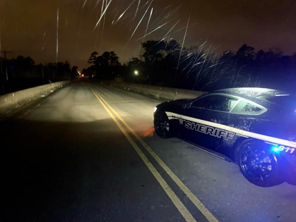
A few hours earlier, Wilmington closed Martin Luther King Jr. Parkway from downtown Wilmington to South College Road due to icy conditions. By Friday evening, I-140 Wilmington/Shallotte exit was also closed and the Dan Cameron Bridge considered impassable.
The Brunswick County Sheriff's Office reported via Facebook post that bridges over I-140 near mile marker 20 are beginning to ice over, and there are reports of multiple wrecks. The office said conditions will "continue to deteriorate" throughout the night, and urges people to stay off the roads if possible.
- Owen Hassell
7 p.m.: Ice begins to accumulate on roads, creating hazardous conditions
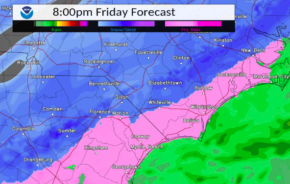
Conditions have started to worsen in Wilmington and surrounding areas, with freezing rain accumulating, especially on bridges and overpasses.
Icy conditions will continue overnight before moving off shore around daybreak Saturday, according to the National Weather Service. Wilmington can expect as much as a quarter inch of ice, which could cause downed tree limbs and power lines, power outages and dangerous travel conditions. Some areas of Brunswick, New Hanover and Pender counties could see closer to half an inch of ice by 7 a.m. Saturday.
Residents are warned to be careful when walking outside as well, as falls are common on walkways, patios and roadways covered with ice, according to the National Weather Service.
According to a post on the official Wilmington Twitter account, city officials closed Martin Luther King Jr. Parkway from downtown Wilmington to South College Road due to icy conditions. By Friday evening, I-140 Wilmington/Shallotte exit was also closed and the Dan Cameron Bridge considered impassable.
As roads have already started to get slick, the Brunswick County Sheriff's Office reported via Facebook post that bridges over I-140 near mile marker 20 are beginning to ice over, and there are reports of multiple wrecks. The office said conditions will "continue to deteriorate" throughout the night, and urges people to stay off the roads if possible.
![Ice was starting to form on surfaces just before nightfall in Wilmington Friday Jan. 21, 2022. The wintry weather is expected to continue through the night. [MATT BORN/STARNEWS]](https://s.yimg.com/ny/api/res/1.2/yioAH8i6bIet105ZAq_lVA--/YXBwaWQ9aGlnaGxhbmRlcjt3PTk2MDtoPTY0MA--/https://media.zenfs.com/en/star-news/4d1c288d645701c12a147bffa54a28e7)
The North Carolina Department of Transportation also encourages people to stay off the roads unless absolutely necessary, according to a news release sent Friday afternoon. The department reported it had put 1.2 million gallons of brine on roads and bridges in the state to reduce hazardous road conditions, but officials are still "extremely concerned" about black ice accumulating on roads.
“Please, if you can, stay off the roads,” said N.C. Department of Transportation’s Chief Operating Officer Beau Memory in the news release. “We’ll have a lot of work ahead of us in the coming days and our crews need to focus on getting roads safe for travel again.”
There are still no reported power outages in the Wilmington area, but that could change throughout the evening as ice and wind puts strain on powerlines and tree limbs.
Temperatures in Wilmington are around 30 degrees with wind chills at 21 degrees, according to the National Weather Service. Temperatures are expected to continue dropping overnight. Wilmington remains under an ice storm warning until noon Saturday.
- Sydney Hoover
5 p.m.: Wilmington bracing for overnight impacts of icy weather
As sunset approaches, Wilmington and surrounding areas are preparing for temperatures to drop and winter weather to move in.
Roads remain clear, but officials warn after sundown, residents should stay home as temperatures drop well below freezing and precipitation continues. Road conditions are expected to be icy throughout the day Saturday. Duke Energy is also reporting no power outages yet but has crews in place to address any outages that occur, including crews from as far away as Indiana and Ohio. Residents are encouraged to report any outages to Duke Energy.
New Hanover County Emergency Management Director Steven Still said the county is taking a "proactive stance" to address overnight damage done by the freezing rain. He said the county is bringing in extra people from the emergency operations center to work overnight and into the morning to assess damage from tree limbs, power lines, and other incidents.
Additionally, New Hanover County is working with community groups to provide supplies and warming shelters to homeless living in Wilmington and "continues to support our homeless agencies in their efforts," Communications and Outreach Coordinator Alex Riley said in an email. Emergency management and public safety is available to help any residents in need of assistance or shelter, but the county does not plan to provide community shelters at this time.
More: Wilmington prepares for icy weather: Community shelters look to open, residents gear up
All flights to and from Wilmington International Airport are also canceled Saturday due to threats of icy weather overnight and throughout the weekend.
- Sydney Hoover
3 p.m.: County urging residents to 'stay home' as temperatures drop
New Hanover County officials are warning residents to stay off the roads as temperatures start to drop with a mass of moisture from the gulf moving in.
"I don't have any good advice for driving on the roads other than please, please don't do it," said Steven Still, emergency management director for New Hanover County.
Still said those who do have to get out on the roads throughout the weekend should use caution and keep extra space between themselves and the car in front of them to allow more time to stop.
He said while conditions may not seem bad now, temperatures will begin to plummet tonight, bringing changes to conditions with deep freezes. The county plans to assess any damages Saturday morning, and Still said residents are encouraged not to venture out, even when temperatures rise between noon and 2 p.m. Saturday as roads will still be slick.
"Stay home," Still said. "Let us get out and do our assessments like public safety do their job. And hopefully with sunshine and warmer temps this will dissipate."
![Trucks from the Public Service Department put down a salt brine mixture along Front Street in Wilmington, N.C. Thursday Jan. 20, 2022 as steps are being taken to help keep the roads safer once the winter mix of rain, sleet and snow reaches the area. [KEN BLEVINS/STARNEWS]](https://s.yimg.com/ny/api/res/1.2/toMGyAv_VK51lkKbf15oew--/YXBwaWQ9aGlnaGxhbmRlcjt3PTk2MDtoPTY2NA--/https://media.zenfs.com/en/star-news/5b75475281876796663ff9573777a69d)
People staying off the roads will also ease the demand on first responders, Still said. Additional staff plan from the county's Emergency Operations Center plan to monitor conditions overnight, and crews will do an initial assessment of damages Saturday morning.
Still said even a little bit of ice combined with strong wind gusts could lead to damage from tree limbs and power lines, as well as power outages.
"It really doesn't take a whole lot of ice for that to become a major issue," he said.
- Sydney Hoover
2 p.m.: Road conditions expected to worsen after sunset
The National Weather Service in Wilmington is expecting icy conditions to begin worsening toward sunset Friday.
As of 2 p.m. Friday, Wilmington and surrounding areas were only seeing ice sticking on elevated surfaces like tree branches, said Reid Hawkins, science and operations officer for the National Weather Service in Wilmington. He said residents should expect ice to begin accumulating significantly around sunset and overnight, with the potential for snow Saturday morning.
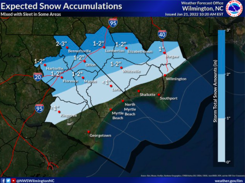
Hawkins said areas west of Wilmington, including Bladen and Columbus counties, could see a couple inches of snow Saturday, but Wilmington will likely see less than half an inch as freezing rain turns to snow overnight.

He said people in the Cape Fear should try to stay home as much as possible starting later this evening as road conditions could begin to worsen as the sun sets and temperatures drop. The low Friday night is expected to be around 25 degrees.
"You need to be really careful," he said. "We're starting to see a little bit of precipitation ... by sunset, definitely need to be home hopefully, or wherever you need to be."
- Sydney Hoover
1 p.m.: Duke Energy encouraging customers to report outages as freezing rain moves in
Light rain continues to fall around Wilmington as crews prepare for the temperatures to remain below freezing throughout the rest of the day.
Temperatures remain right at freezing, and freezing rain is expected to start over the next few hours. Temperatures feel around 21 degrees with the wind chill.
As temperatures continue to drop and freezing rain is anticipated within the remainder of the afternoon, crews from Duke Energy are preparing to repair power outages throughout the day Friday. While Duke Energy is currently reporting very few outages, spokesman Jeff Brooks said customers could see outages as ice begins to accumulate.
He said freezing rain can accumulate very quickly on surfaces like tree limbs, and it only takes about a quarter of an inch of ice to bring a limb down. Freezing rain accumulates much quicker than other winter weather like snow or sleet.
Because of that, Duke Energy has 200 crew members from the Midwest in Wilmington to assist with outages throughout the day. Brooks said because the whole state is expected to see issues from the weather, they brought in assistance from out of state to ensure they can tackle any outages that come up.
"Often, we see hundreds, if not thousands, of very small outages ... across a region so it takes a large number of workers to be able to tackle that scale of damage," Brooks said.
Brooks said customers are encouraged to report outages so crews can continue making repairs where they are needed and so Duke Energy has contact information to provide updates to customers.
- Sydney Hoover
Noon: Slick spots form on roads as rain moves in
Light rain has started to fall in downtown Wilmington and in other parts of the Cape Fear area.
Residents can expect to see rain mixed with freezing rain over the next few hours, according to Carl Morgan, a meteorologist with the National Weather Service office in Wilmington.
The office has had reports of some slippery spots on roads in Pender County, Morgan said. Ice is likely to start forming on roads throughout the area as temperatures remain below freezing this afternoon.
“Some slick spots are likely already developing across the area as temperatures are right at the freezing mark,” Morgan said. “Conditions are going to deteriorate through later this afternoon.”
The Wilmington area can expect to see more potential for snow and sleet as temperatures cool this evening.
“By the time the sun goes down, we’re going to see enough cold air that there will be potential … to possibly change over to sleet and snow,” Morgan said.

A forecast released 11 a.m. Friday from the National Weather Services predicts ice accumulations of between 0.25 and 0.5 inches in nearly all inland areas of New Hanover, Brunswick and Pender counties. Wilmington is expected to get 0.34 inches of ice accumulation.
Only areas right along the coast are forecasted to see less than a quarter inch of ice.
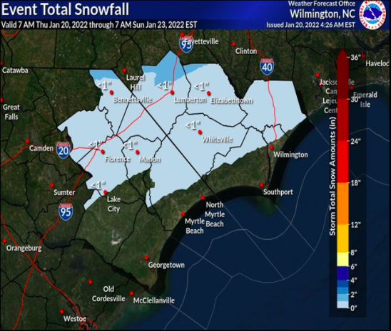
Areas of northwestern Pender County are forecasted to get one inch of snow. The rest of the county can expect to see less than an inch of snowfall.
Northwestern sections of New Hanover and Brunswick Counties could also see less than an inch of snow.
- Emma Dill
11 a.m.: Temperatures hit freezing mark and crews prepare for outages
Temperatures in the Wilmington area have officially hit the freezing mark as of 11 a.m. Friday.
Meanwhile, Duke Energy is gearing up for potential power outages caused by forecasted freezing rain and ice accumulations. Around 200 line and tree workers, some from as far away as the Midwest, gathered on Friday morning in Wilmington, according to a tweet on a Duke Energy Twitter account. The crews will help repair outages in the area as they occur from the storm.
Across the state, Duke Energy has staged approximately 2,500 response workers, including power line technicians, damage assessors and vegetation workers, to help restore power, according to a Friday press release from Duke Energy.
![Power trucks wait along Carolina Beach Road for conditions to possibly worsen as rain falls across the area, with temperatures staying in the mid to low thirty’s today there will be a chance for a wintery mix to continue as the day goes on in Wilmington and the surrounding areas Friday Jan. 21, 2022. [KEN BLEVINS/STARNEWS]](https://s.yimg.com/ny/api/res/1.2/C_a8iTbB0zNzitf94TLt0g--/YXBwaWQ9aGlnaGxhbmRlcjt3PTk2MDtoPTYxNQ--/https://media.zenfs.com/en/star-news/439303f413f014cea328407ccaa097c2)
Those workers include crews normally based in Florida, Indiana and Ohio.
Outages can occur when ice builds up on trees and branches, causing them to fall on power lines. That’s usually the “main culprit” behind power outages during a winter storm, according to the press release. Ice build-up of a quarter-inch or more is often the threshold amount that downs trees and branches.
Nearly all of New Hanover, Brunswick and Pender counties are under an ice storm warning from the National Weather Service, meaning the areas are expected to get at least a quarter inch of ice.
“Our crews are prepared to assess damage and restore electricity to impacted customers as soon as it’s safe to do so,” wrote Jason Hollifield, Duke Energy Carolinas storm director in the release. “We recommend that customers in the forecasted path of the storm prepare for possible power outages.”
As of 11 a.m. Friday, roads conditions remain good in the Wilmington area.
- Emma Dill
10 a.m.: Stay off roads, but here are tips if you need to travel
Freezing rain and ice has yet to hit roads in the Wilmington area, but local officials are asking people to stay off the roads on Friday and Saturday.
"Really do not get out on the road at all,” Steven Still, New Hanover County’s emergency management director, said on Thursday. “Let's let the sun come out, the temperatures warm up on Sunday before you need to go out."
If you do need to venture out, here are some tips from the N.C. Department of Transportation on staying safe while driving.
First and maybe most importantly, slow down. Excessive speed is the top cause of car crashes in the winter, according to the N.C. Department of Transportation. The agency recommends people pass with caution and maintain a safe following distance.
Drivers shouldn’t use cruise control on potentially icy roads and should approach bridges and overpasses with caution since they often are the first road surfaces to freeze.
When driving on icy roads, drivers need to be on the lookout for black ice, which can appear as wet spots on the roadway.
If your car begins to slide while driving, don’t panic. The department of transportation recommends drivers don’t use their brakes and wait for the vehicle to slow down and regain traction before accelerating.
- Emma Dill
9 a.m.: Cold air ‘rapidly’ moves into Wilmington area
Temperatures in Wilmington could cross the freezing mark in the next hour as cold air moves into the area.
Areas to the north and west of Wilmington are already seeing freezing temperatures, according to Reid Hawkins, a meteorologist and the science and operations officer at the National Weather Service office in Wilmington.
"It won't be long," Hawkins said around 8:30 a.m. Friday. "That cold air is really rapidly moving in."
The area saw a range of rain accumulations on Thursday night and Friday morning. Some areas to the west of Wilmington saw a quarter inch of rain while the weather service’s office at Wilmington International Airport saw just 0.07 inches, according to Hawkins.
That rain is expected to have a “minimal” impact on ice accumulations throughout Friday and Saturday. Instead, most of the ice will come from freezing rain set to move into the area on Friday afternoon, Hawkins said.
He warned Cape Fear residents who were expecting to wake up to ice this morning to continue taking the threat of the storm seriously.
"If (you) were expecting there to be ice this morning on the ground, don't get a false sense of security from that," he said, "because we will be definitely seeing that later this afternoon and overnight."
- Emma Dill
8 a.m.: No ice on roads as temperatures stay above freezing
Temperatures in the Wilmington area are hovering just above freezing as parts of the area are seeing light rain and mist.
As of 7:50 a.m. Friday, the National Weather Service office in Wilmington, located at Wilmington International Airport, reported a temperature of 34 degrees.
But that’s expected to drop throughout the morning, according to meteorologist Matt Scalora.
So far, roads in the area haven’t started accumulating ice.
![Traffic travels along Front Street as rain falls across the area, with temperatures staying in the mid to low thirty’s today there will be a chance for a wintery mix to continue as the day goes on in Wilmington and the surrounding areas Friday Jan. 21, 2022. [KEN BLEVINS/STARNEWS]](https://s.yimg.com/ny/api/res/1.2/EDVOEb7h5VPpFn.M9rGZEQ--/YXBwaWQ9aGlnaGxhbmRlcjt3PTk2MDtoPTY0MA--/https://media.zenfs.com/en/star-news/23537906a08977129b46b2d64c920e89)
Roads were clear heading from Leland into Wilmington around 7 a.m. Friday. Streets in downtown Wilmington and near Independence Mall also were in good condition and largely free of traffic.
Road crews with the city of Wilmington and the N.C. Department of Transportation started preparing for the storm yesterday by spreading a mixture of salt and water on roads to help prevent ice accumulations as temperatures drop, David Mayes, the director of Wilmington’s Public Services Department said Thursday.
They will continue spreading salt and sand on the roads to keep conditions safe throughout Friday, but he encouraged residents to stay off the road if they can.
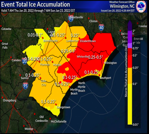
The latest maps released by the National Weather Service on Friday morning show that nearly all of Pender County and most of inland New Hanover and Brunswick Counties can expect to see between 0.25 and 0.5 inches of ice accumulations on Friday and Saturday.
Less than an inch of snow is predicted for nearly all of Pender County along with northeast portions of New Hanover and Brunswick counties, but the predicted rain likely means the snow won't stick to the ground.
- Emma Dill
7 a.m.: Wilmington sees first signs of winter weather
Temperatures will continue to drop Friday morning across the Cape Fear region as the area gears up for what the National Weather Service is calling a major winter storm.
An ice storm warning is currently in effect for all of New Hanover, Brunswick and Pender counties, although the area has yet to see any ice accumulation.
That warning runs through noon on Saturday and means the area can expected at least a quarter of an inch of ice, according to Matt Scalora, a meteorologist with the National Weather Service in Wilmington.
As of 6:30 a.m. Friday, the forecast for the Wilmington area hadn't changed in terms of ice accumulation, Scalora told the StarNews. The area can expect to see rain, which should turn to freezing rain as temperatures drop later this morning, Scalora said.
![Traffic travels along HWY 421 as rain falls across the area, with temperatures staying in the mid to low thirty’s today there will be a chance for a wintery mix to continue as the day goes on in Wilmington and the surrounding areas Friday Jan. 21, 2022. [KEN BLEVINS/STARNEWS]](https://s.yimg.com/ny/api/res/1.2/Yxj1OiXbfkLjooMHQ6oYhw--/YXBwaWQ9aGlnaGxhbmRlcjt3PTk2MDtoPTY0MA--/https://media.zenfs.com/en/star-news/29e259b44538a55e51f49aabbfaaa65b)
Closings and cancellations: Winter storm closings and cancellations for the Wilmington area
"The rain is mainly light this morning, and the radar should fill in a little bit more later in the day, especially this afternoon and evening," he said.
Parts of the Cape Fear region saw rain on Thursday night and early Friday.
Although temperatures in Wilmington are currently above freezing, they're expected to drop later this morning and remain cold throughout the weekend. Those sustained cold temperatures could create icy roads through Sunday, Scalora said.
"It's going to prevent the roads from drying out," he said. "So there could be some refreezing, especially with the cold temperatures tomorrow night."
- Emma Dill
This article originally appeared on Wilmington StarNews: Wilmington NC winter weather: What is area seeing during ice storm?

