Wednesday's live updates: Hurricane Ian bears down on Florida; Marion County prepares
As Hurricane Ian continues its assault on Florida, thousands of Marion County residents and county officials are making preparations for the storm, which is expect make landfall just north of Cape Coral.
The National Hurricane Center placed Marion County under a tropical storm warning at 11 a.m. Tuesday and by 5 a.m. the forecast track showed Ian had increased to a Category 4 major hurricane as it approaches Punta Gorda.
Previous coverage | Tuesday's live updates: Marion County gets ready for Hurricane Ian
Photos | Marion County prepares for Hurricane Ian: Sandbags, shelters, gas tanks fill-ups and more
What's happening with football?: How Hurricane Ian is impacting Marion County high school football schedule for Week 6
8:20 p.m. | In a Facebook post Wednesday night, the Ocala Police Department encouraged people to stay off the roads
8:10 p.m. | Power outage update for Marion County; 2,344 customers without electricity
Provider (Customers): Outages
Central Florida Electric Cooperative (9): 0
Clay Electric Cooperative (16,601): 198
Duke Energy (74,536): 1,811
Ocala Electric Utility (52,146): 281
SECO Energy (64,766): 54
Total (208,049): 2,344
6:40 p.m. | Get live updates on Hurricane Ian from Gannett Florida
Details here.
4 p.m. | Birds, dogs and other pets shelter with their owners at Vanguard High School
And here are some photos from that same shelter:
3:50 p.m. | Ocala is getting a new Waffle House on SR 200. But Hurricane Ian has delayed the opening
Andy Fillmore has the story.
Power outages: Updated power outages across Marion County
Currently, only 304 out of 208,049 customers with five power companies are without power in Marion County. That means 98.48% of all customers have power at 4 p.m. Wednesday.
Provider (Customers): Outages; %Power out
Central Florida Electric Cooperative (9): 9-0; 0.0%
Clay Electric Cooperative (16,601): 19; 0.11%
Duke Energy (74,536): 264; 0.35%
Ocala Electric Utility (52,146): 21; 0.04%
SECO Energy (64,766): 0; 0.0%
Total (208,049): 304; 1.52%
3:25 p.m. | Hurricane Ian makes landfall in exact same location as Hurricane Charley in 2004
Hurricane Ian, packing 155 mph wind, made its official landfall over Cayo Costa, a barrier island just north of North Captiva Island off the cost of Fort Myers. Landfall was just after 3 p.m. Wednesday.
It is the exact same place where Hurricane Charley made landfall in August 2004.
Charley, also a Category 4 storm, was much smaller than Ian. However, Ian will take nearly the same path as Charley, moving from Port Charlotte near Fort Myers northeast over Orlando and out to sea near Daytona Beach.
Far southeastern Marion County is expected to get about 15 inches of rain and 60 mph wind, while the far western side is expected to get 6 inches of rain and 40 mph wind through Thursday afternoon.
Landfall occurs when half the eye of a hurricane crosses over land, including barrier islands. The middle of that halfway line is the center. The city at the center is consider the official landfall location. That turned out to be Cayo Costa for both Charley and Ian.
1:55 p.m. | All eyes on Hurricane Ian as the storm approaches
The statewide perspective: Follow along
For an up-to-date account of what's happening throughout Florida, check out USA TODAY'S live blog.
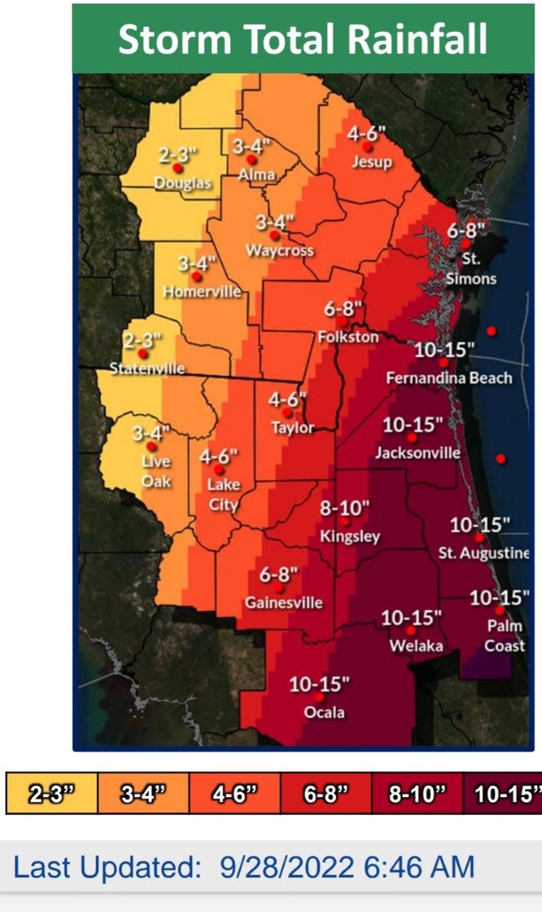
Rainfall projections: National Weather Service shares predicted rainfall
The National Weather Service in Jacksonville has released a rainfall prediction graphic for north Florida. Marion County could receive 6 inches to 15 inches.
Marion shelters: Where to go if you have special needs or a pet?
Marion County Public Schools and the Marion County Emergency Management have announced shelter locations in preparation for Hurricane Ian.
Emergency Management opened West Port High School as a special-needs shelter; all other shelters will open at noon Wednesday. One of those is the only pet-friendly shelter: Vanguard High School, 7 NW 28th St., Ocala.
The general population shelters for those without pets are:
Dunnellon High School: 10055 SW 180th Ave. Road, Dunnellon
Belleview Middle School: 10500 SE 36th Ave., Belleview
Fort McCoy School: 16160 NE County Road 315, Fort McCoy
Hammett Bowen Jr. Elementary School: 4397 SW 95th St., Ocala
North Marion Middle School: 2085 W. County Road 329, Citra
Emergency management officials encourage citizens to bring supplies to the shelters to last them for up to 48 hours. Those items include: clothing, bedding, medications, food, water, etc.
If you are bringing your pet(s) to the pet-friendly shelter, they must be caged, and you will be required to provide recent immunization documentation. Please bring whatever supplies are needed for your pets to be self-sufficient, and please pick up after them.
Sex offenders or sex predators who need shelter are encouraged to first seek shelter with family or friends in a non-residency restricted area. If that is not an option, they must report to the Marion County Sheriff’s Office Sex Offender/Predator Unit office for shelter. Please bring bedding, hygiene items, snack food and medicine.
Citizens can continue to call the Citizens’ Information Line at (352) 369-7500.
SE Marion may see 18 inches of rain; SW Marion about 6 inches
Rainfall models show that southeast Marion County, the closest to where Ian is expected to pass, could receive up to 18 inches of rain. Wind of 60 mph, with higher gusts, is possible in that area of Marion.
On the west side of Marion County, 6 inches of rain and 40 mph winds are possible. The further east of Ocala you head, the more rainfall and higher wind is expected. Conditions will worsen throughout Wednesday until about 7 a,m. Thursday.
Ian on verge of becoming the fifth Category 5 hurricane to ever hit US
Hurricane Ian's wind speed reached 155 mph early Wednesday, only 2 mph shy of a Category 5 hurricane. There have only been four Category 5 hurricanes to ever hit the United States; three of them made landfall in Florida.
The previous Category 5 storms to hit the United States:
Labor Day Hurricane of 1935, Key West: 185 mph
Hurricane Camille, Mississippi, in 1969: 174 mph
Hurricane Andrew, Homestead, in 1992: 174 mph
Hurricane Michael, Florida Panhandle, in 2018: 162 mph
Sandbag locations open until 7 p.m. Wednesday ahead of Ian
The Marion County Emergency Management Operations Center is currently monitoring Hurricane Ian and has nine sandbag locations operating within Marion County.
These locations will be operational until 7 p.m. Wednesday. These sandbag locations are self-serve; limit of 10 bags per vehicle.
Dunnellon City Complex: 11808 N. Ohio St,, Dunnellon
Wrigley Fields: 405 E. County Road 316, Citra
East Marion Sports Complex: 14445 NE 14th St. Road, Silver Springs
Belleview Sports Complex: 6501 SE 107th St., Belleview
Jervey Gantt Park: 2200 SE 36th Ave., Ocala
Tuscawilla Park (Reilly Arts Center): 800 NE Sanchez Ave., Ocala
Hampton Center: 1501 W. Silver Springs Blvd., Ocala
Martel Recycling Center: 296 SW 67th Ave., Ocala
Marion Oaks: 294 Marion Oaks Lane (behind the Community Center), Ocala
What is storm surge? USA TODAY explains
"Storm surge has accounted for about half of all the deaths in hurricanes since 1970, according to the National Hurricane Center. It caused most of the 1,800 deaths in Hurricane Katrina in 2005," USA TODAY reports.
Read the full piece here.
Get that water now: Publix stores in the path of Hurricane Ian will close Tuesday or Wednesday, reopen Friday
Wednesday's 5 a.m. update: Hurricane Ian to produce heavy rain
Hurricane Ian is now a Category 4 hurricane as it approaches Southwest Florida near Punta Gorda, packing 140 mph wind. The 5 a.m. update from the National Hurricane Center shows a faster trek across Central Florida today through Thursday.
The forecast track now has Ian making landfall at about 2 p.m. today and passing near Orlando before it enters the Atlantic Ocean between Cape Canaveral and Daytona Beach at 2 p.m. Thursday.
Rainfall estimates range significantly in Marion County. There could be as much as 15 inches in far southeastern Marion, where wind could hit 50 mph, with higher gusts. Rainfall could be 6 inches in southwestern Marion, where wind could hit 40 mph beginning late Wednesday into Thursday.
This article originally appeared on Ocala Star-Banner: Hurricane Ian Live Updates: How will Ocala/Marion County fare?

