Weather Permitting: Heat index heading into triple digits again with chance of showers this weekend
An uncertain summer pattern will bring heat, humidity and a decent chance of afternoon and evening showers to the Cape Fear region this holiday weekend.
A combination of sultry high pressure over the Atlantic and a building trough over the middle of the country will give us highs in the low to mid-90s with a heat index approaching triple digits once again.
The difference this time is an increased concentration of moisture which should trigger scattered afternoon and evening showers Some could be heavy, slow-movers like the one that dumped up to 1.5 inches in the Fayetteville area yesterday.
This will remain the case through the weekend, with the Fourth of July looking hot and humid, with nature providing the fireworks in storms scattered across the region.
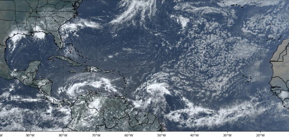
In the tropics, it's still hit-or-miss as to whether a system bound for Central America will get a name before landfall. But if it doesn't there are some candidates off in the Atlantic awaiting their chance.
Here's the setup
High pressure is projected to ease off the coast over the next couple of days, allowing a weak trough to form just east of the Appalachians. This will in turn create a pathway for warm, moist air to climb through the Carolinas, bringing sultry summer conditions to the region.
This setup is slow to develop, so Thursday will remain sunny and seasonably warm with little chance of rainfall. The exception would be closer to the coast, along the Sea Breeze Line, where afternoon showers can quickly pop up.
Friday won't be bad for the start of July, with partly cloudy skies and highs in the low 90s for Fayetteville. There should be an uptick in afternoon showers, but mainly to the south and east of I-95. There's also a decent chance of scattered fog early Friday morning.
The weekend
As high pressure slides further east offshore, look for a weak system that's been causing showers in Florida to climb up the coast. There are no worries about anything tropical developing, but if the system is close enough to the coast, it'll make for a gloomy day at the beach. Inland, look for a few more clouds, with highs in the low 90s and an uptick in afternoon and evening showers.
Sunday may again be a bit foggy early as low temperatures and dew points meet in the low 70s. During the day, a few energy packets are expected to ride between the offshore high and a Deep South trough, and any of them could spark showers. The afternoon is the most likely time. Highs in Fayetteville should reach the low 90s, with a heat index in the triple digits.
July 4 should begin warm and muggy and stay that way all day. Dew points will again reach the low 70s, with a high of about 92 in Fayetteville. There doesn't appear to be any concentrated spark for showers, but any that form could be prolific rainmakers.
Down the road
Look for this pattern to continue well into next week. Highs will likely top out in the low 90s, with lows in the low 70s and plenty of humidity to spark scattered showers. There's a greater chance of rain as a front approaches at the end of next week.
In the tropics: Bonnie-wannabe remains on course for landfall in Nicaragua as a borderline tropical storm It could possibly cross into the Pacific and recharge.
Behind this system, there's a train of waves crossing the Atlantic. but conditions appear less-than-favorable for development over the next week. Something to watch, rather than worry.
Have a great July 4 weekend!
Got a weather question? Chick Jacobs can be reached at ncweatherhound@gmail.com or NCWeatherhound on Twitter.
The Fayetteville Observer app is free to download.
This article originally appeared on The Fayetteville Observer: Heat index to hit triple digits for July 4 weekend in Fayetteville NC

