Tropics watch: Potential Tropical Cyclone 2 moving near Venezuela; new tropical storm warning issued
Heavy rain and gusty winds are spreading over the southern Windward Islands as Potential Tropical Cyclone Two continues to head west toward the Caribbean.
The disturbance passed the Windward Islands and moved near Venezuela's northeastern coast late Tuesday night. A tropical storm warning was issued for portions of the coasts of Venezuela and Colombia, according to the National Hurricane Center.
The National Hurricane Center said the system is likely to become a tropical storm as it moves west across the southern Caribbean Sea.
The system is expected to become a hurricane with 75-mph winds as it moves ashore along the Nicaraguan coast Saturday morning.
However, the Hurricane Center warned there is higher-than-normal uncertainty in what the system will do once it reaches the southwestern Caribbean Sea late Thursday and Friday.
► Your guide to preparing for the 2022 hurricane season in Florida
It's future strength depends on how much it interacts with land through Thursday.
Tropical storm watches and warnings have been issued.
The next named storm would be Bonnie.
"We expect the system to cross the southern Windward Islands and Trinidad and Tobago Tuesday evening into Tuesday night, possibly as a tropical storm, with maximum sustained winds of 39-73 mph," said AccuWeather Senior Meteorologist Adam Douty said.
Elsewhere in the Atlantic basin, the National Hurricane Center continues to monitor two tropical waves.
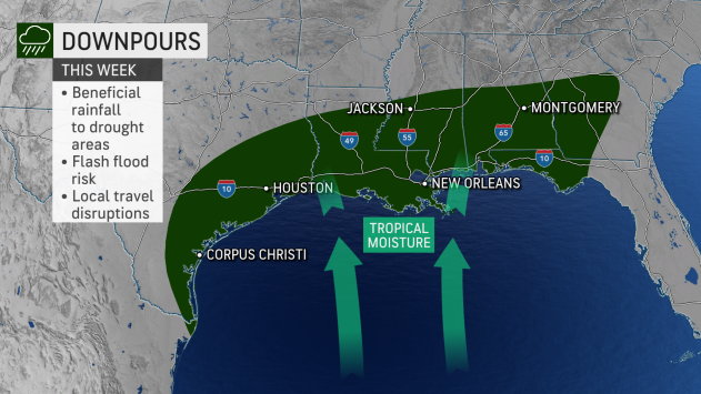
A system in the northern Gulf of Mexico was tagged as Invest 95L Tuesday morning. It's showing some potential of strengthening as it moves toward the Texas coast.
Farther to the east in the central Atlantic is another tropical wave also showing potential for development.
Hurricane season 2022: CSU, AccuWeather forecasters agree: Active hurricane season ahead. Here's what you need to know
WeatherTiger prediction: Since 2017, a ludicrous 101 named storms have formed. Expect more this hurricane season
Here's the latest update from the NHC as of 11 p.m. June 28:
Details on Potential Tropical Cyclone Two
Location: 105 miles west-northwest of Trinidad and about 430 miles east-southeast of Curacao
Maximum wind speed: 40 mph
Direction: west-northwest at 26 mph
Next advisory: 5 a.m. Wednesday
What's out there and where are they?
Potential Tropical Cyclone Two: The disturbance was centered about 105 miles west-northwest of Trinidad and is moving to the west at 26 mph. A westward or west-northwest motion is expected through Thursday.
On the forecast track, the system will pass near or over portions of the southern Windward Islands by tonight, and move over the southern Caribbean Sea or near the northern coast of Venezuela on Wednesday and Thursday.
Invest 95L: An area of low pressure is centered over the northwestern Gulf of Mexico. Showers and thunderstorms associated with the low have increased overnight but remain disorganized.
Tropical wave 2: A tropical wave located more than 1,000 miles east of the Windward Islands continues to produce disorganized showers and thunderstorms.
How likely are they to strengthen?
Potential Tropical Cyclone 2 is forecast by NOAA to become a #hurricane in Caribbean. 5 years in satellite era (post-1965) have had June-July Caribbean hurricanes: 1966, 1996, 2003, 2005, 2021. All 5 were above-normal Atlantic hurricane seasons per NOAA definition. pic.twitter.com/DnGWoPzDme
— Philip Klotzbach (@philklotzbach) June 27, 2022
Potential Tropical Cyclone Two: Maximum sustained winds remain near 40 mph with higher gusts. Slight strengthening is forecast during the next few days if the disturbance remains over water. Tropical-storm-force winds extend outward up to 60 miles from the center.
Conditions appear conducive for development if the disturbance remains over water, and it will likely become a tropical storm near the southern Windward Islands or while moving west across the southern Caribbean Sea.
It also could become a hurricane, with winds of 75 mph, Saturday before reaching the coast of Central America.
Formation chance through 48 hours: high, 70 percent.
Formation chance through 5 days: high, 90 percent.
Invest 95L: Some additional development of this system is possible as it moves slowly west or west-southwest and approaches the coast of Texas during the next two days.
"We continue to show a low chance for development across the western Gulf of Mexico into the middle of the week," AccuWeather Senior Meteorologist Adam Douty said.
Light wind shear, combined with above-normal water temperatures, will contribute to a small window in which a tropical depression could try to form on Tuesday or Wednesday, Douty added.
Formation chance through 48 hours: medium, 40 percent.
Formation chance through 5 days: medium, 40 percent.
The area of unsettled weather in the Gulf of Mexico has been tagged as #Invest95L this morning.
Some slow development (30% chance) is possible as the disturbance drifts west toward the Texas/Mexico coastlines.
Locally heavy rain will likely be the biggest impact.
MG pic.twitter.com/KeTSnKJX2f— Weather.us - Weather Forecasts For Professionals (@WeatherdotUS) June 28, 2022
Tropical wave 2: This system is forecast to interact with another tropical wave to its east over the next several days, and some gradual development is possible later this week while the overall system moves west-northwest at around 15 mph across the central tropical Atlantic.
Formation chance through 48 hours: low, near 0 percent.
Formation chance through 5 days: low, 30 percent.
Who is likely to be impacted?
#PTC2 remains an open wave this morning as it keeps sliding west-northwest.
The most persistent convection has moved to the north side of the wave. If the center relocates here, it may have implications on the forecast track and potential intensity.https://t.co/2tM8Bh2NON
MG pic.twitter.com/lgEItLyIlj— Weather.us - Weather Forecasts For Professionals (@WeatherdotUS) June 28, 2022
Potential Tropical Cyclone Two: The Potential Tropical Cyclone is expected to produce heavy rain across the southern Windward Islands and the northeastern coast of Venezuela starting tonight into Wednesday.
Tropical storm conditions are expected in the warning area in the southern Windward Islands tonight, over Islas Margarita and the adjacent islands Wednesday morning, and over the ABC Islands later on Wednesday.
Tropical storm conditions are possible in the watch area along the northeastern coast of Venezuela tonight.
A tropical storm warning is in effect for:
Grenada and its dependencies
Islas de Margarita, Coche and Cubagua
Bonaire
Curacao
Aruba
Coast of Venezuela from the Peninsula de Paraguana westward to the Colombia/Venezuela border including the Gulf of Venezuela
Coast of Colombia from the Colombia/Venezuela border westward to Santa Marta
A tropical storm watch is in effect for:
Coast of Venezuela from Pedernales to Cumana
Invest 95L: Residents along the Texas coastline should all be on alert for the potential of a quick-forming system.
Even if a tropical system does not form, tropical downpours are likely across the Gulf Coast states this week.
"An influx of tropical moisture, streaming up from the Gulf of Mexico will be running into a stalled front across the southern U.S. These opposite forces will squeeze out the moisture in between, leading to downpours from Texas to the Florida Panhandle," said Douty.
Tropical wave 2: It's too early at this time to determine if there will be any impact to the U.S. from this tropical wave.
Forecasters urge all residents to continue monitoring the tropics and to always be prepared during what's expected to be an active hurricane season.
Weather watches and warnings issued for your area
If you can't see any local weather warnings here, you'll need to open this story in a web browser.
The next five days
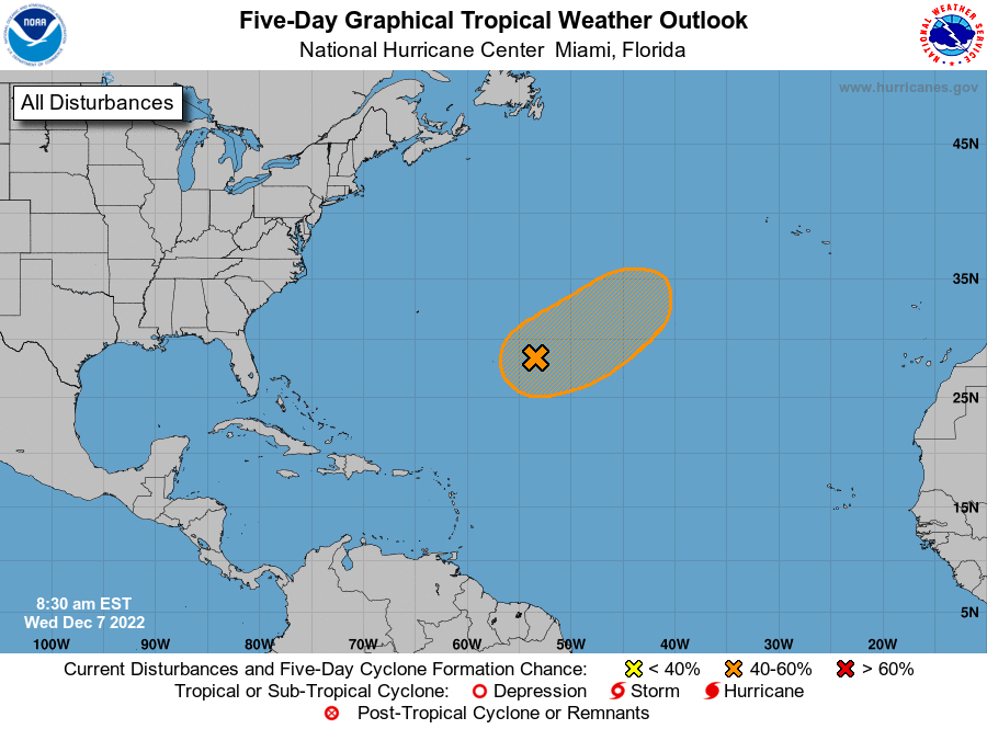
See the National Hurricane Center's five-day graphical tropical weather outlook below.
Excessive rainfall forecast
What's out there?
Systems currently being monitored by the National Hurricane Center.
What's next?
We will continue to update our tropical weather coverage daily. Download your local site's app to ensure you're always connected to the news. And look at our special subscription offers here.
This article originally appeared on Palm Beach Post: NHC: Potential Tropical Cyclone 2 could become Tropical Storm Bonnie

