Storm could dump 8-14 inches of snow on Lenawee County from Wednesday morning to Thursday

It’s time to make French toast.
What else are people planning to make when they stock up on eggs, milk and bread as a winter storm approaches?
Lenawee County residents likely will be heading to the grocery stores to stock up because southern Michigan is in the path of a significant winter storm that is expected to arrive Wednesday morning. Forecasters at the National Weather Service say it could dump 8 to 14 inches of snow across the region by the time it’s done Thursday evening. A map showing prospective snowfall amounts posted online Monday morning by the NWS showed Lenawee County in an area that could get 12 to 15 inches of snow.
"Do what you've got to do to prepare for the snow," NWS meteorologist Dave Kook said early Monday morning. "You know it's coming."
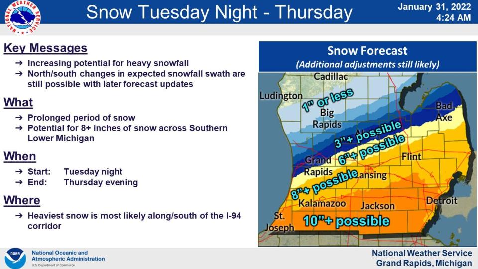
After temperatures warm to about 40 degrees Tuesday, precipitation is expected to start as rain before 4 a.m. Wednesday, then become a rain and snow mix. It will then turn into a “long duration of light to moderate intensity snowfall expected between Wednesday morning and Thursday evening,” the winter storm watch issued by the NWS said. “Snow may become briefly heavy at times.”
“Gusty winds from the north on Thursday will also contribute to some blowing of snow,” the watch said.

Some Lenawee County communities issued snow emergencies on Monday that are to scheduled start about the time the storm is expected to arrive:
Adrian: From 12:01 a.m. Wednesday to 10 a.m. Friday.
Blissfield: 12:01 a.m. Wednesday to 4 p.m. Friday.
Morenci: 5 a.m. Wednesday to noon Friday.
Tecumseh: From noon Wednesday to noon Friday.
During snow emergencies, vehicles must not be parked on the streets so that snowplow crews can remove snow. Owners of vehicles found parked on the street during the emergency could receive a ticket and the vehicle could be towed.
In Adrian, residents are reminded to clear snow from around fire hydrants near their homes. The news release from the city announcing the snow emergency said a 3-foot radius should be cleared around hydrants along with a path to the street.

Once the snow stops, skies are expected to clear again with partly to mostly sunny weather expected. However, it will be well below freezing again, with high temperatures on Friday and Saturday expected to be about 17. The low temperature on Friday is expected to be minus 4; on Saturday the low is expected to be 5.
So prepare for some slow-going Wednesday and Thursday — and when you head out to the store to stock up on provisions, don’t forget the cinnamon for that French toast.
The Detroit Free Press contributed to this report.
This article originally appeared on The Daily Telegram: Winter storm expected to arrive Wednesday in Lenawee County

