Snow expected Monday in northern Ohio setting stage for tricky afternoon commute
Snow.
That dreaded four-letter word is back. More snow is expected across all of northern Ohio Monday.
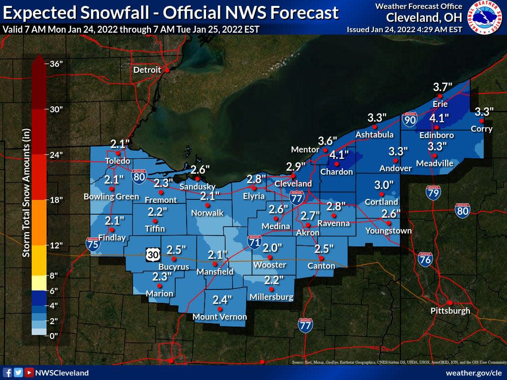
The National Weather Service says anywhere from 2 to 3 inches is expected to fall across the region as another so-called Alberta Clipper moves across the state.
This comes on the heels of a much stronger Alberta Clipper on Sunday that snarled traffic and forced many businesses to close for the day as 5 inches or more of snow fell in parts of Summit County with 7 inches recorded near Hinckley in Medina County.
More: Downtown Akron power may be back by 11 a.m. as water, gas line, electricity repairs continue
All this is on top of the foot of snow or so that fell in the Martin Luther King Day storm in parts of northern Ohio.
The weather service warns road conditions could quickly deteriorate Monday afternoon before the snow moves out of the region from west to east. Chilly temperatures and snow showers will be in its wake with sub-zero windchills expected Tuesday night through Thursday morning.
More: Crash on I-77 North at I-277 blocks lane of traffic, causes delays Monday morning
Forecasters say temperatures will likely not reach above freezing before next week.
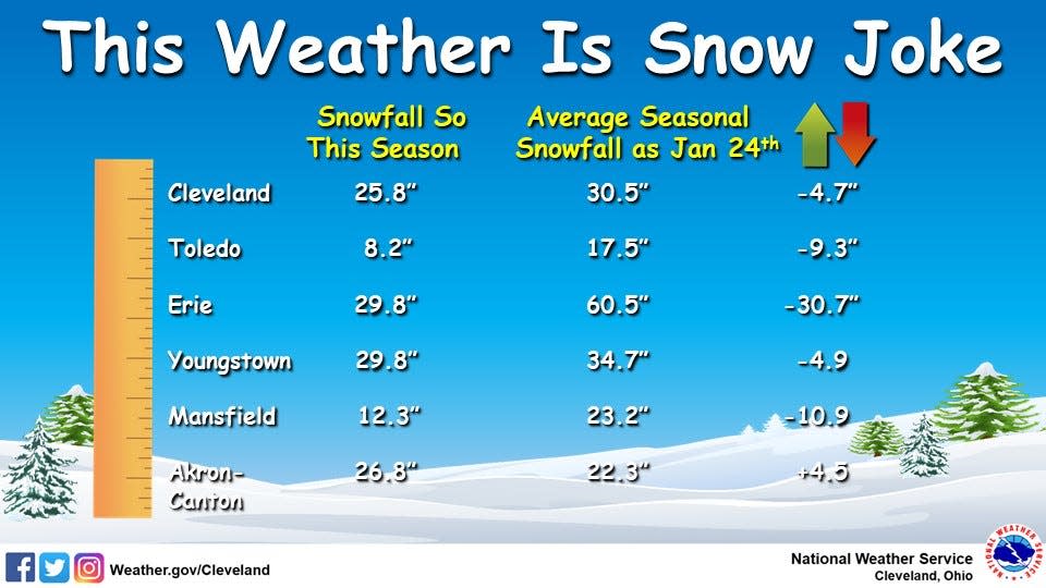
Although it might not seem like it lately, winter got off to a slow start. Most of northern Ohio is still behind in terms of average snowfall so far this winter.
Before the flakes started flying from Monday's round of snow, most major cities were behind in snow tallies and will likely remain that way despite more snow.
Mansfield was around 10 inches shy of where it should be by now, with Cleveland down by nearly 5 inches. The only exception was Akron that was hit particularly hard by the MLK Day storm.
Akron's snowfall total for the winter season was up nearly 5 inches over the average.
Here is the 7-day forecast:
Monday
Snow showers, mainly after noon. High near 30. South wind around 8 mph. Chance of precipitation is 100%. Total daytime snow accumulation of 1 to 3 inches possible.
Monday night
Snow showers likely before 10 p.m., then a chance of snow showers and freezing rain between 10 p.m. and 4 a.m., then a chance of snow showers after 4 a.m. Cloudy, with a low around 15. Southwest wind around 8 mph becoming west after midnight. Chance of precipitation is 60%. Little or no ice accumulation expected. New snow accumulation of less than one inch possible.
Tuesday
A chance of snow showers. Partly sunny, with a high near 22. Northwest wind 6 to 8 mph. Chance of precipitation is 40%. New snow accumulation of less than a half inch possible.
Tuesday night
Mostly cloudy, with a low around 5. Calm wind.
Wednesday
Partly sunny, with a high near 18. Light west wind.
Wednesday night
Mostly clear, with a low around 0.
Thursday
Partly sunny, with a high near 28.
Thursday night
A chance of snow showers. Cloudy, with a low around 19. Chance of precipitation is 40%.
Friday
A chance of snow showers. Mostly cloudy, with a high near 24. Chance of precipitation is 40%.
Friday night
Mostly cloudy, with a low around 4.
Saturday
Partly sunny, with a high near 20.
Saturday night
Mostly cloudy, with a low around 7.
Sunday
Mostly cloudy, with a high near 30.
Craig Webb, who is behind his average speed of shoveling his sidewalks, can be reached at cwebb@thebeaconjournal.com.
This article originally appeared on Akron Beacon Journal: Snow expected across northern Ohio in time for Monday's evening commute
