Blizzard warning for RI: Storm may drop 18-24 inches of snow; travel could be 'impossible'
Editor's note: For the most recent forecast and news, please see our Saturday blizzard coverage.
Rhode Island will be under a blizzard warning for all of Saturday, with a powerful nor'easter likely to drop 18 to 24 inches of snow, drive wind gusts up to 60 mph and flood coastal areas, according to the National Weather Service.
"A powerful winter storm will impact much of southern New England Saturday into Saturday evening, bringing heavy snow, blizzard conditions to the coast, possibly damaging winds and coastal flooding," the Weather Service says.
"Thundersnow is possible," the Weather Service says.
This story is available to all as a public service and is made possible by our subscribers. Please consider supporting quality local journalism with a subscription to The Providence Journal. Here's our latest offer.
More: RI may implement travel ban during Saturday blizzard
The National Weather Service issued the blizzard warning at 9:40 a.m. , replacing a winter storm warning.
Snowfall rates of 2 to 4 inches per hour are possible at times, and travel "could be very difficult to impossible," the Weather Service says.

Does your town have a parking ban?: Here's where to leave your car during a snowstorm in RI
Where will the most snow fall this weekend?
Computer models are coming into better agreement on the storm's track, and the Weather Service is forecasting the heaviest snow, 24 to 30 inches, over southeastern Massachusetts, including the South Shore and part of Cape Cod.
A blizzard warning has also been issued for the east coast of Massachusetts, including Cape Cod, Martha's Vineyard and Boston.
Explained: What is thundersnow and how does it happen?
AccuWeather says, "As the storm quickly strengthens, it will create hurricane-force winds across parts of eastern New England, raising concerns for significant blowing and drifting of snow, reduced visibility, power outages and blizzard conditions. Along the coastline, flooding and beach erosion will be a serious threat, especially in eastern Massachusetts."
Providence Journal on your phone: Download the Providence Journal app ahead of the storm
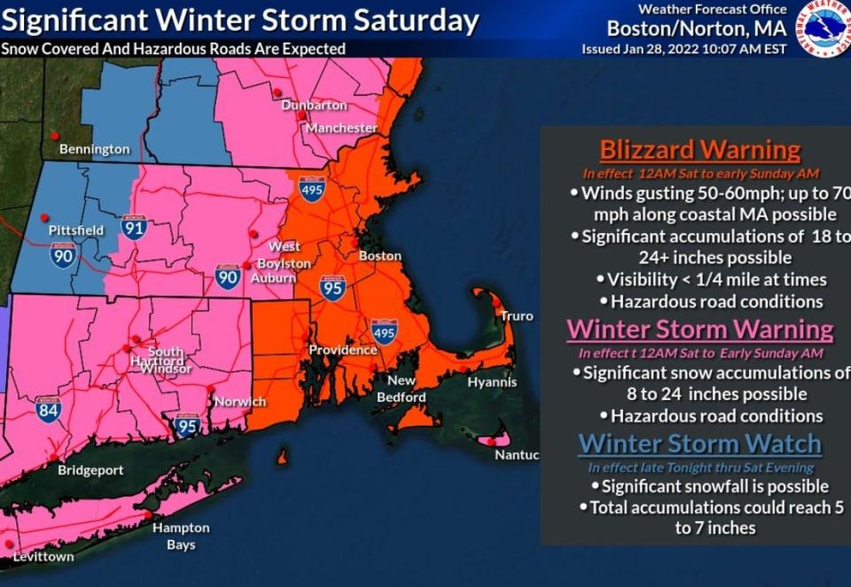
"It's possible the blizzard warning may need to expanded westward into" Rhode Island and other parts of Massachusetts, the Weather Service said.
A look through our history: Can you guess how much snow Providence got on its snowiest day?

Will we see a 'bomb cyclone'?
The storm is expected to strengthen rapidly Friday night off the mid-Atlantic coast, with pressure dropping "an impressive" 40 millibars in 24 hours, yielding "a bomb cyclone," the Weather Service says.
Several factors, including "a fire hose of Atlantic moisture, will result in very heavy snowfall across (Rhode Island) and eastern Massachusetts," the Weather Service says. Cold air in New England create "snow-to-liquid ratios at or above 10:1," according to the Weather Service. The high in Providence should reach just 19 degrees Saturday.
From the archives: Blizzard of ’78 remains a touchstone for New Englanders who lived through it
When will the snow start?
Southern New England should wake up to some accumulating snow and the snow won't stop until late Saturday.
Heavy snow and high winds are possible this weekend. Plan ahead to avoid travel during the storm. pic.twitter.com/5YUJHjeFO6
— RIDOTNews (@RIDOTNews) January 27, 2022
"While the greatest forcing and heavy snow won't start in earnest until after 5 to 7 am or so, light to moderate snow will move into the south coast around midnight and quickly spread north and west," the Weather Service says.
The storm will extend over two tide cycles, Saturday morning and Saturday evening, according to the Weather Service. If the timing holds, the strongest wind and storm surge should happen around low tide, generating mostly minor coastal flooding "with pockets of moderate flooding," the Weather Service said.
jperry@providencejournal.com
(401) 277-7614
On Twitter: @jgregoryperry
Be the first to know.
Sign up for our breaking news alerts
This article originally appeared on The Providence Journal: RI Snow forecast: Nor'easter may drop 18-24 inches, blizzard conditions

