Recalling Wutip, February's first Category 5 typhoon
This Day In Weather History is a daily podcast by Chris Mei from The Weather Network, featuring stories about people, communities and events and how weather impacted them.
--
Typhoon Wutip, known in the Philippines as Tropical Depression Betty, is the first Category 5-equivalent typhoon recorded in February.
It all started on Feb. 16th, when a low-pressure formed south of the Marshall Islands. It continued to develop as it moved westward. On the 18th, the system officially turned into a tropical depression.
Tropical Storm #Wutip continues to move west at 13 mph with maximum sustained winds at 65 mph. Please stock up on essentials and finalize your emergency preparedness kit. Wutip is forecast to pass southwest of #Chuuk and #Fananu and move toward #Guam. https://t.co/v4qad2Jjpb pic.twitter.com/jes8PYz9ef
Tropical Storm U.S. Coast Guard on Twitter: "Tropical Storm #Wutip continues to move west at 13 mph with maximum sustained winds at 65 mph. Please stock up on essentials and finalize your emergency preparedness kit. Wutip is forecast to pass southwest of #Chuuk and #Fananu and move toward #Guam. https://t.co/v4qad2Jjpb pic.twitter.com/jes8PYz9ef / Twitter" continues to move west at 13 mph with maximum sustained winds at 65 mph. Please stock up on essentials and finalize your emergency preparedness kit. Wutip is forecast to pass southwest of U.S. Coast Guard on Twitter: "Tropical Storm #Wutip continues to move west at 13 mph with maximum sustained winds at 65 mph. Please stock up on essentials and finalize your emergency preparedness kit. Wutip is forecast to pass southwest of #Chuuk and #Fananu and move toward #Guam. https://t.co/v4qad2Jjpb pic.twitter.com/jes8PYz9ef / Twitter" and U.S. Coast Guard on Twitter: "Tropical Storm #Wutip continues to move west at 13 mph with maximum sustained winds at 65 mph. Please stock up on essentials and finalize your emergency preparedness kit. Wutip is forecast to pass southwest of #Chuuk and #Fananu and move toward #Guam. https://t.co/v4qad2Jjpb pic.twitter.com/jes8PYz9ef / Twitter" and move toward U.S. Coast Guard on Twitter: "Tropical Storm #Wutip continues to move west at 13 mph with maximum sustained winds at 65 mph. Please stock up on essentials and finalize your emergency preparedness kit. Wutip is forecast to pass southwest of #Chuuk and #Fananu and move toward #Guam. https://t.co/v4qad2Jjpb pic.twitter.com/jes8PYz9ef / Twitter". U.S. Coast Guard on Twitter: "Tropical Storm #Wutip continues to move west at 13 mph with maximum sustained winds at 65 mph. Please stock up on essentials and finalize your emergency preparedness kit. Wutip is forecast to pass southwest of #Chuuk and #Fananu and move toward #Guam. https://t.co/v4qad2Jjpb pic.twitter.com/jes8PYz9ef / Twitter" U.S. Coast Guard on Twitter: "Tropical Storm #Wutip continues to move west at 13 mph with maximum sustained winds at 65 mph. Please stock up on essentials and finalize your emergency preparedness kit. Wutip is forecast to pass southwest of #Chuuk and #Fananu and move toward #Guam. https://t.co/v4qad2Jjpb pic.twitter.com/jes8PYz9ef / Twitter"
By the 20th, the depression strengthened into a tropical storm and received the name Wutip from the Japan Meteorological Agency. The next day, Wutip intensified into a typhoon.
Wutip passed over the Federated States of Micronesia from Feb 19–22 as a Category 2.
Over the next three days, Wutip continued to intensify until it reached its first peak on Feb. 23rd. As a Category 5-equivalent super typhoon, it passed over the southwest of Guam. It sustained winds of 195 km/h for at least 10 minutes, and winds of 270 km/h for at least a minute.
HT @chrisdolcewx #Wutip likely to track south of #Guam, but expected to be only second February #typhoon to track within 200 nautical miles of Guam. Irma (1953) was the other. Northwest Pacific #tropical cyclones typically at a min in Feb. Forecast: https://t.co/4UTU5PRg2C pic.twitter.com/n0LUCQqjpZ
HT Jonathan Erdman on Twitter: "HT @chrisdolcewx #Wutip likely to track south of #Guam, but expected to be only second February #typhoon to track within 200 nautical miles of Guam. Irma (1953) was the other. Northwest Pacific #tropical cyclones typically at a min in Feb. Forecast: https://t.co/4UTU5PRg2C pic.twitter.com/n0LUCQqjpZ / Twitter" Jonathan Erdman on Twitter: "HT @chrisdolcewx #Wutip likely to track south of #Guam, but expected to be only second February #typhoon to track within 200 nautical miles of Guam. Irma (1953) was the other. Northwest Pacific #tropical cyclones typically at a min in Feb. Forecast: https://t.co/4UTU5PRg2C pic.twitter.com/n0LUCQqjpZ / Twitter" likely to track south of Jonathan Erdman on Twitter: "HT @chrisdolcewx #Wutip likely to track south of #Guam, but expected to be only second February #typhoon to track within 200 nautical miles of Guam. Irma (1953) was the other. Northwest Pacific #tropical cyclones typically at a min in Feb. Forecast: https://t.co/4UTU5PRg2C pic.twitter.com/n0LUCQqjpZ / Twitter", but expected to be only second February Jonathan Erdman on Twitter: "HT @chrisdolcewx #Wutip likely to track south of #Guam, but expected to be only second February #typhoon to track within 200 nautical miles of Guam. Irma (1953) was the other. Northwest Pacific #tropical cyclones typically at a min in Feb. Forecast: https://t.co/4UTU5PRg2C pic.twitter.com/n0LUCQqjpZ / Twitter" to track within 200 nautical miles of Guam. Irma (1953) was the other. Northwest Pacific Jonathan Erdman on Twitter: "HT @chrisdolcewx #Wutip likely to track south of #Guam, but expected to be only second February #typhoon to track within 200 nautical miles of Guam. Irma (1953) was the other. Northwest Pacific #tropical cyclones typically at a min in Feb. Forecast: https://t.co/4UTU5PRg2C pic.twitter.com/n0LUCQqjpZ / Twitter" cyclones typically at a min in Feb. Forecast: Jonathan Erdman on Twitter: "HT @chrisdolcewx #Wutip likely to track south of #Guam, but expected to be only second February #typhoon to track within 200 nautical miles of Guam. Irma (1953) was the other. Northwest Pacific #tropical cyclones typically at a min in Feb. Forecast: https://t.co/4UTU5PRg2C pic.twitter.com/n0LUCQqjpZ / Twitter" Jonathan Erdman on Twitter: "HT @chrisdolcewx #Wutip likely to track south of #Guam, but expected to be only second February #typhoon to track within 200 nautical miles of Guam. Irma (1953) was the other. Northwest Pacific #tropical cyclones typically at a min in Feb. Forecast: https://t.co/4UTU5PRg2C pic.twitter.com/n0LUCQqjpZ / Twitter"
On Feb. 25th, Wutip reached its second peak with winds of 185 km/h for at least 10 minutes, and winds of 260 km/h for at least one minute.
Wutip surpassed Typhoon Higos from 2015 as the strongest Feb. cyclone on record.
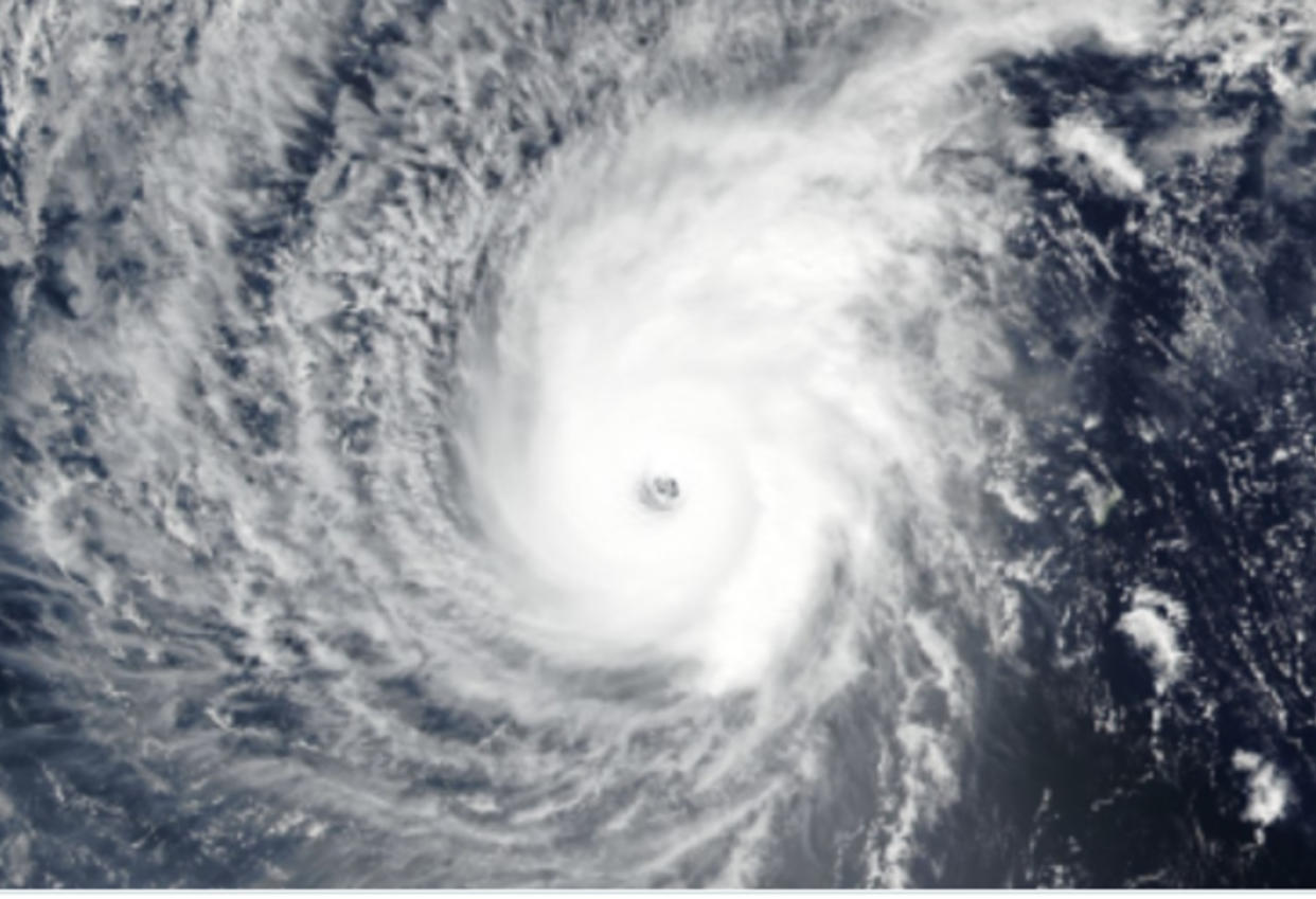
A mesmerizing close-up of Typhoon #Wutip, seen earlier today from the #Himawari-8 satellite. The rotating cloud features in the eye of the storm are called mesovortices. Latest on Wutip: https://t.co/taQBQsUwN1 pic.twitter.com/YsEvWiqxWJ
A mesmerizing close-up of Typhoon NOAA Satellites on Twitter: "A mesmerizing close-up of Typhoon #Wutip, seen earlier today from the #Himawari-8 satellite. The rotating cloud features in the eye of the storm are called mesovortices. Latest on Wutip: https://t.co/taQBQsUwN1 pic.twitter.com/YsEvWiqxWJ / Twitter", seen earlier today from the NOAA Satellites on Twitter: "A mesmerizing close-up of Typhoon #Wutip, seen earlier today from the #Himawari-8 satellite. The rotating cloud features in the eye of the storm are called mesovortices. Latest on Wutip: https://t.co/taQBQsUwN1 pic.twitter.com/YsEvWiqxWJ / Twitter"-8 satellite. The rotating cloud features in the eye of the storm are called mesovortices. Latest on Wutip: NOAA Satellites on Twitter: "A mesmerizing close-up of Typhoon #Wutip, seen earlier today from the #Himawari-8 satellite. The rotating cloud features in the eye of the storm are called mesovortices. Latest on Wutip: https://t.co/taQBQsUwN1 pic.twitter.com/YsEvWiqxWJ / Twitter" NOAA Satellites on Twitter: "A mesmerizing close-up of Typhoon #Wutip, seen earlier today from the #Himawari-8 satellite. The rotating cloud features in the eye of the storm are called mesovortices. Latest on Wutip: https://t.co/taQBQsUwN1 pic.twitter.com/YsEvWiqxWJ / Twitter"
— NOAA Satellites (@NOAASatellites) NOAA Satellites on Twitter: "A mesmerizing close-up of Typhoon #Wutip, seen earlier today from the #Himawari-8 satellite. The rotating cloud features in the eye of the storm are called mesovortices. Latest on Wutip: https://t.co/taQBQsUwN1 pic.twitter.com/YsEvWiqxWJ / Twitter"
Overall, Wutip caused at least US$3.3 million in damages in Guam and Micronesia and destroyed aroaund 160 houses in Gaum.
To learn more about Typhoon Wutip, listen to today's episode of "This Day In Weather History."
Subscribe to 'This Day in Weather History': Apple Podcasts | Amazon Alexa | Google Assistant | Spotify | Google Podcasts | iHeartRadio | Overcast'
Thumbnail courtesy of Wikipedia

