Rare freeze outlook issued for South Florida with cold front this weekend
- Oops!Something went wrong.Please try again later.
A sharp kink in the high-racing jet stream will slide a bite of Canadian winter through South Florida this weekend with temperatures forecast to dig into the 30s from areas east of Lake Okeechobee to the coast.
The cold air, which is expected to be the rawest Sunday morning, triggered a freeze outlook from the National Weather Service — a hazardous weather product that hasn’t been activated by the Miami office in recent memory and possibly not since 2010, said Warning Coordination Meteorologist Robert Molleda.
Huge savings: $1 for 3 months
Subscribe today to support local journalism and enjoy unlimited digital access including videos, apps, sports news, and more. Special introductory offer for new subscribers only.
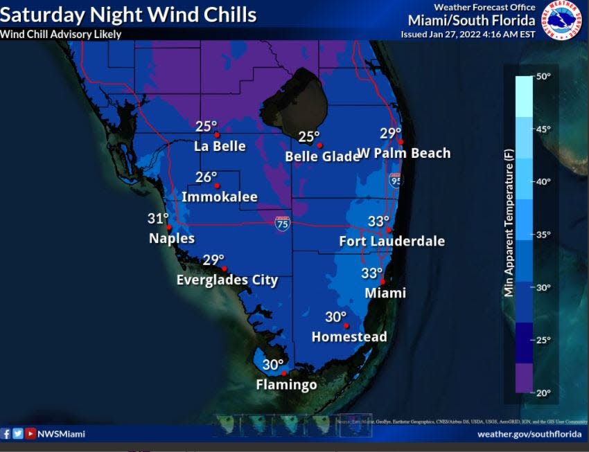
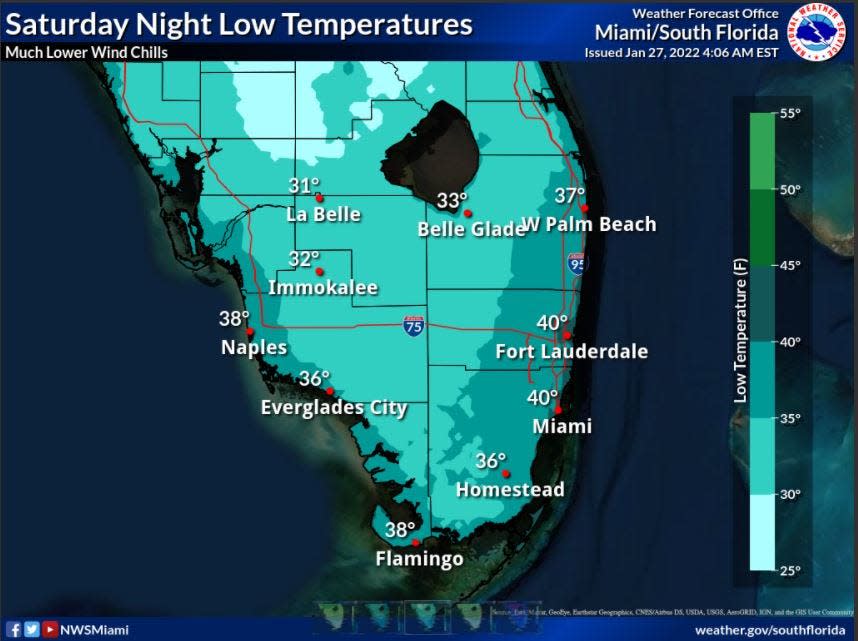
Temperatures Sunday morning are forecast to range from 32 degrees or below across inland portions of South Florida with the mid- to upper-30s to near 40 at the coast.
Brutal wind chill temperatures in the 20s near Lake Okeechobee and 30s near the coast are also possible.
Cold and COVID: Do at-home COVID-19 tests still work if they get cold? What if they freeze in my mailbox?
More: Four decades later, the day it snowed in South Florida still delights
More: Early 2022 hurricane forecast: La Niña, the AMO and 'bazillion' caveats are all in play
An area of low pressure forecast to spin up off the coast of the Carolinas and deepen as it moves northeast will help tug the frigid air all the way to Cuba, with Key West dipping to a potential 50 degrees early Sunday.
That’s a low the capital of the Conch Republic hasn’t experienced in seven years.
“The locals here will have hats and scarves on and the tourists will think it’s great because it’s better than Buffalo,” said Chip Kasper, a meteorologist in the NWS Key West office. “Everybody’s definition of cold is different.”
Palm Beach County stands ready to open shelters
Palm Beach County officials are readying to open shelters if needed, said Emergency Manager Mary Blakeney.
She said decisions on opening will be made before 11 a.m. each morning of the cold event based on the evening’s forecast. The criteria to open a shelter is when the ambient temperature is forecast to fall to 40 degrees or less for a period of four consecutive hours or more. Shelters also will open if the wind chill is forecast to reach 35 degrees or less for a period of four hours.
Blakeney said the county has opened shelters just twice in the past two years — in January 2020 and February 2021 — and both times in the Glades area.
More: Marine industry blocks slower boat speeds in popular Jupiter Narrows after FWC approval
“If we do have to open them, I just want to say they are not just for individuals who are homeless but for anyone who may not have access to adequate heat,” she said.
Cold shelters are typically open between 7 p.m. and 7 a.m.
The temperature at Palm Beach International Airport is forecast to dip to 36 degrees Saturday night into Sunday morning. That wouldn’t break the record of 35 degrees set Jan. 30, 1966, but the airport hasn’t seen many days below 38 degrees.
There were four days between 2014 and 2018 when temperatures hit 38 degrees. The last day it was below 38 at the airport was Dec. 14, 2010 when it reached 32 degrees.
The record low temperature for West Palm Beach is 27 degrees set on Jan. 20, 1977 - the day after it snowed in South Florida.
“It’s not looking great for us but I can’t say whether it will be as catastrophic as 2010,” said Ryan Roth, vice president of Roth Farms in Belle Glade. “2010 was pretty ugly.”
The bluster of 2010 began in January with the coldest 12-day stretch on record and ended with the coldest December on record.
Roth said Wednesday he had already started calling pilots to reserve helicopters for Saturday night and Sunday night. The helicopters help mix the air at the surface — a technique that mitigates the radiational cooling that allows warm air to escape into the night.
More: Something more insidious than pythons is coming for Florida's wildlife and it's terrifying
More: Mystery solved: Beachgoers see odd giant structure float by Palm Beach County's coast
“I think this is going to be a widespread event so it’s a matter of deciding what you are going to take care of,” Roth said. “We’ll focus on things that are within three to four weeks of harvest.”
That means sweet corn. Roth said the current crop was particularly pricey to grow as supply chain issues raised prices on fertilizer and fuel.
“This is by far the most expensive crop of sweet corn we’ve grown,” he said.

Residents might want to cover cold-vulnerable plants with old sheets or towels. Vulnerable plants include succulents, new transplants, seedlings and aglaonema, or Chinese evergreen. Also, expensive or rare orchids should be brought inside or protected.
Sugarcane - a tropical plant and economic driver in the Glades - is also cold adverse and will die if there is a freeze of four hours or more, said Marianne Martinez, vice president of corporate communications for Florida Crystals Corp. She said in 2010 temperatures were below freezing for six or more hours resulting in a hard freeze and major loses on all of the Glades-area farms.
After a freeze, farmers use satellite technology to analyze areas for dehydration and where sugarcane harvesting should be prioritized.
"The faster the temperature warms after a freeze, the quicker the damaged sugarcane needs to be harvested and milled by our teams," Martinez said.
Meteorologists said freeze watches and wind chill and frost advisories will likely be issued as the weekend approaches. The freeze outlook is active through Monday morning.
The deep winter temperatures are an anomaly in recent years. New 30-year temperature normals released last year showed December, January and February had overnight, or minimum temperatures, increase by 1.3 degrees in West Palm Beach over the previous 30-year period. The new normals cover 1991-2020.
Gauges from the Naples Municipal Airport to Fort Lauderdale Executive Airport showed similar overnight flareups in winter.
Paul Walker, senior meteorologist with AccuWeather, said he’s predicting a low of 35 degrees early Sunday morning, which would tie the 1966 record.
“There’s just a lot of energy coming down from Canada,” he said.
High temperatures Saturday and Sunday will struggle to reach 60 degrees in Palm Beach County. Wind gusts Saturday could hit 30 mph, falling to 20 mph Sunday.
Kasper said his greatest concern is for boaters in the Keys who will grapple with the high winds.
“Fishing and diving probably aren’t great ideas this weekend,” he said.
Kmiller@pbpost.com
@Kmillerweather
Weekend forecast
Friday: 74 high, 46 overnight low
Saturday: 55 high, 36 overnight low
Sunday: 58 high, 44 overnight low
This article originally appeared on Palm Beach Post: South Florida weather: Strong cold front triggers rare freeze outlook

