How NASA Is Accidentally Helping People Spy on Putin’s War
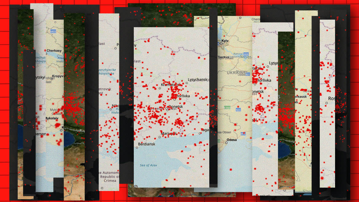
At first glance, NASA’s Fire Information for Resource Management System (FIRMS) website does not look like something that can help track a war. Originally built to help firefighters and other officials keep track of global wildfires, the FIRMS webpage shows something that looks a bit like Google Earth with little red dots scattered across the globe. Each dot represents a fire NASA’s satellites detected with infrared sensors pointed at the Earth’s surface.
If you move the map to Ukraine, even the most casual observer is able to see that the country is ablaze. A line of fires vaguely correlating with the front line is spread along eastern and southern Ukraine. As it turns out, NASA’s satellites, in an effort to track wildfires, are inadvertently capturing the fires in the aftermath of shelling, burning munitions depots, and other heat sources from the conflict.
For people trying to track the conflict only from public sources, FIRMS can be a lifesaver. Social media coverage of the war in Ukraine is a deluge of claims, counterclaims, unattributed or misattributed footage of fighting, as well as actors pushing their own agendas. The location and effect of air and artillery strikes, such as those by the now-famous HIMARS rocket artillery system, is one such information battlefield.
Any tool that helps verify where and when a strike by Ukrainian or Russian forces happened assists journalists and Twitter’s Open-Source Intelligence (OSINT) community, sometimes called OSINTers, in figuring out what is happening on the ground. Two of the most well-publicized methods are geolocating photographs or videos and getting satellite imagery of the fighting from private companies. For instance, speculation about what caused last week’s explosions at Saki Air Base in Crimea is largely based on combining an analysis of videos taken from afar with imagery bought from commercial satellite services like Planet or Airbus.
FIRMS Data: 2022-08-14_18:05
Added 56 locations to kml
Filtered 13 locations by proximity to other fires
Removed 9 false positives pic.twitter.com/FrM58d2hSu— Def Mon (@DefMon3) August 14, 2022
FIRMS has quickly become another such tool in the OSINTers’ toolkit. “I think I was first made aware of [FIRMS] around mid-April this year,” OSINTer and podcast host Kyle Glen, who has since used the system on a daily basis, told The Daily Beast. According to Glen, “I mostly use it to look at areas where I know heavy fighting is occurring to try and get an idea of where the front lines are, I also use it to try and help with geolocation of videos of fires burning.”
It can also indicate if an area needs more investigation. Def Mon, a popular analyst who uses the program, told The Daily Beast that, “[FIRMS] can be used to connect dots. Like here. I saw FIRMS first, and then found a tweet I connected to it.” Given that Ukraine has recently sought to target Russia’s supply lines to blunt their offensive, Glen found that “fires in unusual places such as bridges or roads are always worth investigating.”
For others, FIRMS has a more personal meaning. One user, who has since left Twitter but recounted his experiences in a war diary, relayed how he used FIRMS to track fighting near his home during the battle for Kyiv.
NASA's FIRMS (Fire Information for Resource Management System) is actually pretty good at mapping active fighting by plotting large fires. This is the last 24 hours in Kyiv, as you can see with clustered returns, fighting is ongoing around Irpin. https://t.co/pKLBtWgVrh pic.twitter.com/LXaDWg62Hv
— OSINTtechnical (@Osinttechnical) March 13, 2022
NASA has been using satellites to track fires since at least 2000, but their satellites have never been used to track a conflict at this scale. Beyond the fact that the war in Ukraine is the largest conventional conflict since the system launched, the war is characterized by heavy use of artillery and rockets, which FIRMS is better able to capture. FIRMS can corroborate social media or press reports of a strike by showing where there are large blazes. If a large pile of munitions or fuel depot is hit, it often burns bright and long enough for NASA’s satellites to detect and register it as a wildfire. Locations hit by artillery can also register, but only if the barrage started a fire.
FIRMS’ ability to layer information like road networks and display data across time has also come in useful for those looking at the war in the long-term. Twitter users aggregate data from FIRMS to look at the intensity of fighting over the course of weeks or months. Def Mon argues that “if we take a one week snapshot of Ukraine, the FIRMS indications can more or less be used to show us the rough frontline.” Dr. Phillips O’Brien, professor of strategic studies at the University of St Andrews and prolific user of Twitter to track the war in Ukraine, compares FIRMS data over different weeks to show trends in Russian artillery use against Ukrainian forces.
Useful as FIRMS has become, there are some limitations. Because the system is designed for wildfires, it shows larger fires and does not speculate on what might have started them. Twitter users also have to work hard to separate “false positives” (an actual wildfire, housefire, or industrial heat sources like a factory smokestack) from strikes on military and logistical facilities. According to Def Mon, FIRMS “becomes less reliable during summer, since stuff burns for all kinds of reasons.” Like all satellites monitoring events on Earth, the quality of detection also depends on the weather and when the satellites pass overhead.
If you compare a 5-day map of Firms fire in the Donbas from July 5-9 and 10-14 they basically show Russian ranged fire declining enormously (and much of the fire you see in the second picture is Ukrainian ranged fire on Russian lines) pic.twitter.com/zCJMVZnesU
— Phillips P. OBrien (@PhillipsPOBrien) July 17, 2022
As is to be expected with any publicly available tool, not everyone knows how to use it well. Most Twitter users engaging with FIRMS regularly are aware of the system’s limitations, but like all open-source tools, less discerning users are liable to jump to conclusions. Tweets speculating wildly about recorded strikes or the intensity of fighting without considering the weather or timing of satellite passes are not uncommon. The trend is not unique to users looking at FIRMS and speaks to a broader need to professionalize OSINT on social media.
The future of FIRMS as a tool to track conflict is unclear. Other wars, such as the conflicts in Yemen and Ethiopia, are much harder to track with NASA’s satellites as they are currently calibrated. Some users, like Glen, just want small features added to improve usability, such as overlaying location names on satellite imagery. FIRMS’ blog is entirely focused on improving the user experience for those using the tool to fight wildfires, so it’s not clear that NASA is interested in officially supporting observers of the conflict. As it stands though, FIRMS has proven invaluable for providing public insight into one of the most violent conflicts of the 21st century.
Get the Daily Beast's biggest scoops and scandals delivered right to your inbox. Sign up now.
Stay informed and gain unlimited access to the Daily Beast's unmatched reporting. Subscribe now.

