More heavy rain is coming to South Florida and the Keys. Why, when and how much?
South Florida woke to bright skies and a comfy 79 degrees.
Open your front door, step out and enjoy the fresh air. Chances are you’ll be inside for much of the weekend — because a lot of wet is coming, courtesy of a tropical disturbance that is currently in the Caribbean.
According to the National Hurricane Center’s 2 p.m. Saturday report, satellite, radar and surface data indicates that that broad area of low pressure just west-southwest of Grand Cayman Island is continuing to become better organized. Wind circulation has become better defined with increased thunderstorm activity and falling surface pressures since Friday evening.
Interests in W Cuba, the Florida Keys and southern Florida should monitor the progress of this system. Locally heavy rainfall will be possible over portions of the Cayman Islands, Jamaica, Cuba, southern Florida, the Florida Keys and the NW Bahamas through the weekend. #95L
— National Hurricane Center (@NHC_Atlantic) October 23, 2020
“Environmental conditions are conducive for further development while the low drifts toward the north and northwest this weekend,” the center said, putting the chances for development in two and five days at 100%.
Forecasters say the disturbance will form into a tropical depression Saturday afternoon or evening.
South Florida rain chance, flood watch
Speaking of 90%, that’s the rain chance for South Florida and the Florida Keys Sunday, too, because of this system in the Caribbean, the National Weather Service in Miami forecasts in its hazardous weather outlook issued Saturday morning. The mass of wet weather should start arriving through Saturday afternoon and evening.
A flood watch for South Florida from South Miami-Dade to Metro Palm Beach is in effect until 8 p.m. Sunday. A flood watch is also in effect until 11 a.m. Saturday in the Keys.
All of this rain — possibly up to six inches in spots — coincides with a time of high tides.
Oct 24: While we continue to keep an eye on the disturbance in the western Caribbean Sea and brace for a rainy weekend, Today In Florida Weather History reminds us that 15 years ago, Hurricane Wilma tracked across South Florida. https://t.co/hYSPLDahdn pic.twitter.com/IEkdwRXkMx
— NWS Miami (@NWSMiami) October 24, 2020
Where the Caribbean system is going
The National Hurricane Center said the Caribbean system could move near western Cuba on Monday and move across the southeastern Gulf of Mexico by Tuesday.
Western Cuba and the Yucatan Peninsula should pay attention to updates, the center said. A NOAA Hurricane Hunter reconnaissance aircraft is to investigate the disturbance Saturday afternoon.
A Caribbean disturbance could mean a wet weekend for South Florida
Hurricane Epsilon update
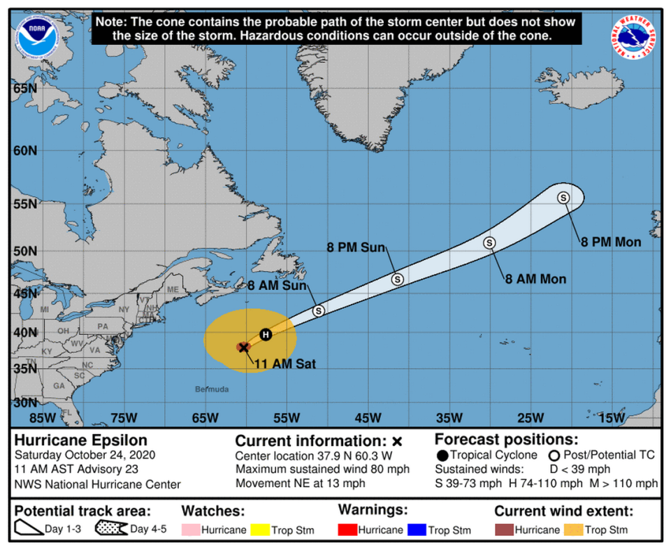
Hurricane Epsilon continued to hurl forward Saturday morning at about 465 miles north-northeast of Bermuda as it as it headed northeast at 13 mph with 80 mph winds, according to the hurricane center’s 11 a.m. update.
Still, the hurricane center said Epsilon is expected to see a “rapid acceleration” by Saturday evening through Sunday with some slow weakening over the weekend before turning into a “large and powerful post-tropical cyclone on Sunday.”

