Monument Announces Completion of Upscaled Phase 1 Drilling in the Field at the Murchison Gold Project
Figure 1

Completed drill collars from the Burnakura project Phase 1 drill program
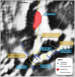
Figure 2

Satellite image with the Munro Bore trend shown and location of completed RC holes
Figure 3
Aeromagnetic image showing the main mineralized trendsand completed drill hole collars at the FLC2 prospect
Figure 4
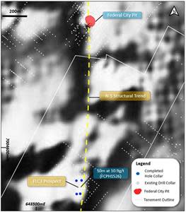
Aeromagnetic image showing the main mineralized trend and completed drill hole collars at the FLC3 prospect
Figure 5
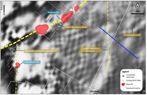
Aeromagnetic image showing the Burnakura Shear Zone and subsidiary structures and completed drill hole collars at the Authaal East target area
Figure 6
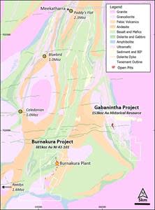
Murchison Area Map
Figure 7

Collar Location Plan FLC2
Figure 8
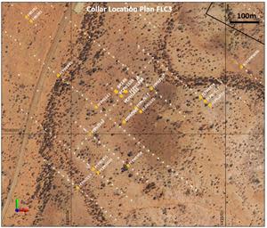
Collar Location Plan FLC3
VANCOUVER, British Columbia, Sept. 20, 2021 (GLOBE NEWSWIRE) -- Monument Mining Limited (TSX-V: MMY and FSE: D7Q1) “Monument” or the “Company” is pleased to announce the successful completion of an upscaled Phase 1 18,000 metre air core (“AC”) and reverse circulation (“RC”) drill program at its Murchison Gold Project in Western Australia.
Highlights
Completion of 46 RC holes for 3,465 metres targeting the Munro Bore Extension target as well as the FLC2 and FLC3 prospects, within the Burnakura Project Area. Hole depths ranged from 40 to 160 metres and were located outside of the current resource areas.
A total of 349 AC holes were completed for 10,484 metres focusing on high quality structural targets defined from geophysical surveys in areas of shallow cover.
The Munro Bore mineralized structure has an extension into Monument’s tenement (“Munro Bore Extension”).
Geological mapping and interpretation of the completed drilling is in progress, and subject to results obtained, follow up drill programs will be planned.
All of the samples generated from the drilling have been delivered to ALS Geochemistry, Perth, and results are expected to be received between October and November 2021.
A drill program consisting of over 5,500 metres of combined RC and diamond drilling (“DD”) targeting beneath open pits along the high-grade North of Alliance (“NOA”) structure is at an advanced planning stage and selection of a drill contractor is in progress.
Monument commenced its Phase 1 AC and RC drill program on July 3rd 2021 (as announced on July 20th 2021) and completed it by August 21st 2021 (Figure 1).
This first phase of drilling was designed to test new high quality structural targets beneath cover for potential mineralization that may lead to the identification of shallow stand alone or satellite gold deposits to supplement the current resource base. In addition, the drilling tested the strike continuation at Munro Bore Extension that is adjacent to Munro Bore (not owned by Monument). Munro Bore has estimated historical resources of 266,000t at 1.6g/t Au (reported in “Technical Project Review and Independent Valuation Report (Short Form)” prepared by Giralia Resources NL and reviewed by Ravensgate Mining Industry Consultants in January 2011).
A total of 46 RC holes for 3,465m were completed against a plan of 12 holes for 1,260m, comprised of 1,301m for the planned Munro Bore Extension and additional 2,164m for the FLC2 and FLC3 prospects that was originally planned in the phase two. It was brought forward to take advantage of increased drill rig availability.
A total of 349 AC holes were completed for 10,484m at the Authaal East, Burnakura South and Junction targets against a plan of 430 AC holes for 16,680m at Munro Bore Extension, Banderol South and Junction. The targets were tested as planned except the eastern line of the Junction target was not drilled due to steep terrain. The depth to blade refusal was generally less than anticipated resulting in fewer metres drilled than originally planned. Drill holes were angled at 60 degrees and generally spaced at 25m with lines spaced at between 400m to 950m.
Figure 1 is available at https://www.globenewswire.com/NewsRoom/AttachmentNg/4f5e7d03-ad4f-47d4-ad54-556b158b3923
Drill holes generally intersected lithology consistent with available mapping and included volcanic and Banded Iron Formation (“BIF”) sequences which are the same lithologies that host the Alliance Mineral Resource. In addition, the continuation of the Munro Bore mineralization could be identified by a zone of shearing, alteration, pyrite mineralization and quartz veining.
All samples have been dispatched from site and have been received by ALS Geochemistry, Perth. Due to the backlog for gold assays and multi-element geochemical results which the mining industry is currently experiencing, results aren’t expected to be received until October through to the end of November. Higher priority samples have been prioritized with the lab.
Geological interpretation of the completed Phase 1 drilling is ongoing and follow up mapping and sampling of some of the drill lines will be planned. Interpretations will be reviewed and refined once assays are received to improve understanding of the geological controls of the mineralized zones and guide phase 2 drilling program on Burnakura, which will be announced accordingly.
A full review of all historical maps and reports is planned to be completed for the Gabanintha project. An initial review indicated there is a substantial amount of information that needs to be collated before regional exploration programs can be designed. Additional pit mapping and a structural interpretation of the main Gabanintha pit area will also be completed to assist in drill hole targeting underneath the existing pits.
Munro Bore Extension Target
A total of 12 holes for 1,301m of RC were drilled at the Munro Bore Extension target (Figure 2). Three lines of drilling were completed with holes spaced between 40m and 50m to extend the tested mineralised strike length 160m, into Monument’s M51/178 tenement. Holes were drilled to depths from 60m to 160m.
An historical Mineral Resource at Munro Bore was reported by Giralia Resources in 2010, estimated to be 266,000t at 1.6g/t Au. The drilling confirmed the strike continuation of this structure at a south-west orientation directly into Monument’s M51/178 tenement. No significant drilling or evaluation of this structure within M51/178 has been previously completed.
The drilled structure is dipping to the north-east and is over 20m wide, defined by shearing, alteration, pyrite mineralization and quartz veining. There is no indication whether economic mineralization continues along this structure into Monument’s tenement at this stage.
Figure 2 is available at https://www.globenewswire.com/NewsRoom/AttachmentNg/ef9379be-3d59-451f-93fe-55752a94b693
FLC2 and FLC3 Prospects
The FLC2 and FLC3 targets were added to the Phase 1 drill program to take advantage of increased drill rig availability. A total of 31 holes for 1,882m were completed at the FLC2 prospect (Figure 3) and 4 holes for 282m were completed at the FLC3 prospect (Figure 4). Holes were drilled to depths between 40m and 95m.
The FLC2 target is located approximately 400m to the south of the Banderol pit and appears to be associated with the southward continuation of the same structural contact that hosts the mineralization within the pit. The Banderol pit produced an estimated 28koz ounces of gold at 2.9g/t pre-2005 (“Updated Mineral Resource, Burnakura Project, Western Australia, Australia NI 43-101 Technical Report” prepared by SRK, July 2018, or “July 2018 NI43-101 Technical Report”).
In addition to this main north-south trending structure, there appears to be structures orientated in a north-easterly direction, which were also targeted by this drill program.
The FLC2 target has been previously tested with fences of RAB drilling and several shallow RC holes that identified numerous areas of low-grade gold mineralization as well as some higher grade zones with best intersections of 10m at 3.4g/t from hole FCPH1635 and 3m at 5.0g/t from FCPH1871. This drill program has tested beneath the higher grade intersections into fresh rock, and will increase the understanding of the main controls on mineralization. The mineralization generally appears to be associated with mafic and ultramafic contacts.
Figure 3 is available at https://www.globenewswire.com/NewsRoom/AttachmentNg/8c878603-8cc0-44a3-8213-6393de3dfb4d
The FLC3 prospect is located approximately 1km to the south of the Federal City deposit and is interpreted to occur on the southward continuation of the same structure that hosts the mineralization there. The Federal City pit produced an estimated 1.2koz at 1.3g/t pre-2005 (July 2018 NI43-101 Technical Report). The FLC3 prospect contains several shallow high-grade gold intercepts that include 10m at 10.9g/t from FCPH1526. The prospect has been previously tested with multiple lines of RAB drilling and several shallow follow up RC holes that have not been further tested at depth. The mineralization appears to be trending in a north-south orientation which is subparallel to lithology and magnetic highs. The lithology consists of ultramafic and mafics.
Figure 4 is available at https://www.globenewswire.com/NewsRoom/AttachmentNg/e499cd08-0e12-4a0f-9a2c-da774c43d3ba
The four RC holes that were drilled were designed to test for mineralisation along strike and at depth and to confirm the orientation of the high-grade mineralisation. The holes intersected an ultramafic sequence containing a narrow interval of basalt that has increased deformation and alteration at some of its contacts, which may indicate the mineralization is focused along lithological contacts.
A full listing of historical drill hole details showing intersections above 1 g/t gold for FLC2 and FLC3 and accompanying drill collar plans are shown in Appendix 1.
Authaal East, Banderol South and Junction Targets
The Authaal East, Banderol South and Junction Targets had not been previously drilled and are high quality structural targets defined from geophysical surveys, in areas of shallow cover.
A total of 30 holes for 1,172m were completed at the Authaal East target which is located approximately 500m to the east of the Authaal pits (Figure 5). The Authaal pit has produced an estimated 13koz of gold at 5.7g/t and the Authaal North pit has produced an estimated 7.1koz at 2.9g/t pre-2005 (July 2018 NI43-101 Technical Report). This drill target was added to the drill plan after the July 20th 2021 press release.
The Authaal East target
The Authaal East target is located at the northern end of a north-south trending magnetic feature adjacent the Burnakura Shear Zone (“BSZ”). Deposits including Banderol and Federal City are located on north-south trending magnetic features that have been interpreted to be dilational subsidiary structures to the BSZ. There is also an existing line of drilling 320m to the north-east of the completed drilling that have 4 holes ending in assay values greater than 0.1 g/t.
Figure 5 is available at https://www.globenewswire.com/NewsRoom/AttachmentNg/e9eef74a-c218-4ce8-a351-cceb8a5bc767
Banderol South and Junction Targets
A total of 127 AC holes for 3,465m of drilling were completed at the Banderol South target. A reinterpretation of the detailed aeromagnetic data identified a secondary north-south structural splay deviating off the regional north-east BSZ. The orientation of this splay coincides with the structural orientation of mineralized quartz veins within the Banderol open pit and is interpreted to be a continuation of the same structure.
A sequence dominated by felsic volcanics was intersected with minor granodiorite, mafics and ultramafics. Transported cover was generally shallow and less than 1m thick.
A total of 192 holes for 5,847m of AC drilling were completed at the Junction target. The Junction target occurs at the intersection of a known mineralized north-east structural zone with a north-south structure, where an east-west trending magnetic high is observed. As the greenstone lithologies approach the east-west trending magnetic high to the south and approach two granodiorite bodies, they are interpreted to be dragged and deformed potentially creating extensional dilatational zones within the favorable host lithologies.
The drilling at the Junction target intercepted narrow intervals of amphibolite, mafic, ultramafic and possible BIF horizons that are generally less than 100m wide, within a weak to moderately strained granite. Alluvial material covered the whole target area to an average depth of 8m, providing potential to discover hidden mineralization.
The eastern most planned line was not drilled due to steep topography that would make drill rig access difficult. This area will be further investigated and could potentially be tested by a soil sampling program.
Quality Assurance/Quality Control
All drilling completed by Monument utilized the following procedures and methodologies and was carried out under the supervision of Monument personnel. The drilling was carried out by Strike Drilling Pty Ltd under the supervision of Monument’s personnel.
RC drilling used a 5.0-inch face sampling pneumatic hammer with samples collected into 60 litre plastic bags. Samples were collected as 1m splits from the cyclone or as 4m composites from the 60 litre plastic bags. Samples were kept dry by maintaining enough air pressure to exclude groundwater inflow; however, a very small number of RC samples from this drill program were moist or wet.
AC drilling used a 4.0-inch blade and cuttings were collected in one metre intervals and split between a calico bag and a portion was placed onto the ground for spear sampling 4m composites. The 1m calico samples have been stored at the drill site until assay results are received and validated. Composites returning greater than 0.1g/t Au will be subsampled using the 1m calico bags.
Coarse reject samples for all mineralized samples corresponding to significant Au intervals will be retained and stored on-site at the Company controlled core yard.
All drill samples were shipped to ALS Geochemistry laboratory in Wangara, WA for preparation. Sample analysis may take place at some of ALS’s analysis laboratories outside of Western Australia. All samples will undergo routine gold analysis using a 50-gram charge and fire assay with an atomic absorption finish. Selected samples will be dissolved by a four acid digestion and then analyzed for a suite of 33 elements using an ICP-AES finish.
Quality control procedures included the systematic insertion of blanks (1 in 50 samples), duplicates (1 in 40 samples) and sample standards (1 in 20 samples) into the sample stream at the drill site.
The scientific and technical information in this press release has been assembled by Adrian Woodfield, Chief Geologist of the Company, reviewed and approved by Roger Stangler, MEng, FAusIMM, MAIG, a Qualified Person as defined by NI43-101, retained by Golder Associates Pty Ltd.
Background of Murchison Gold Project
Monument Mining Limited holds a 100% interest in the Murchison Gold Project comprising 170km2 of highly prospective Archean Greenstone terrane located approximately 750km north of Perth and 40km southeast of Meekatharra in Western Australia (Figure 1). The project area covers the eastern margin of the Meekatharra-Wydgee greenstone belt within the north-eastern Murchison domain. Historically the Murchison Goldfield has yielded over 15 million ounces of gold since the 1900’s and is still a significant producer from operating mines within the field including the Westgold Resources operations located less than 10km to the west. and is still a significant producer from operating mines within the field including the Westgold Resources operations located less than 10km to the west.
Figure 6 is available at https://www.globenewswire.com/NewsRoom/AttachmentNg/7369407c-887c-48e0-ac5d-574c1317daf6
About Monument
Monument Mining Limited (TSX-V: MMY, FSE:D7Q1) is an established Canadian gold producer that owns and operates the Selinsing Gold Mine in Malaysia. Its experienced management team is committed to growth and is also advancing the Murchison Gold Projects comprising Burnakura, Gabanintha and Tuckanarra JV (20% interest) in the Murchison area of Western Australia. The Company employs approximately 200 people in both regions and is committed to the highest standards of environmental management, social responsibility, and health and safety for its employees and neighboring communities.
Cathy Zhai, President and CEO
Monument Mining Limited
Suite 1580 -1100 Melville Street
Vancouver, BC V6E 4A6
FOR FURTHER INFORMATION visit the company web site at www.monumentmining.com or contact:
Richard Cushing, MMY Vancouver | T: +1-604-638-1661 x102 |
"Neither TSX Venture Exchange nor its Regulation Services Provider (as that term is defined in the policies of the TSX Venture Exchange) accepts responsibility for the adequacy or accuracy of this release."
Forward-Looking Statement
This news release includes statements containing forward-looking information about Monument, its business and future plans (“forward-looking statements”). Forward-looking statements are statements that involve expectations, plans, objectives or future events that are not historical facts and include the Company’s plans with respect to its mineral projects and the timing and results of proposed programs and events referred to in this news release. Generally, forward-looking information can be identified by the use of forward-looking terminology such as "plans", "expects" or "does not expect", "is expected", "budget", "scheduled", "estimates", "forecasts", "intends", "anticipates" or "does not anticipate", or "believes", or variations of such words and phrases or state that certain actions, events or results "may", "could", "would", "might" or "will be taken", "occur" or "be achieved". The forward-looking statements in this news release are subject to various risks, uncertainties and other factors that could cause actual results or achievements to differ materially from those expressed or implied by the forward-looking statements. These risks and certain other factors include, without limitation: risks related to general business, economic, competitive, geopolitical and social uncertainties; uncertainties regarding the results of current exploration activities; uncertainties in the progress and timing of development activities; foreign operations risks, including risks related to changes in mining license rights, tax rates and government royalty requirements; other risks inherent in the mining industry and other risks described in the management discussion and analysis of the Company and the technical reports on the Company’s projects, all of which are available under the profile of the Company on SEDAR at www.sedar.com. Material factors and assumptions used to develop forward-looking statements in this news release include: expectations regarding the estimated cash cost per ounce of gold production and the estimated cash flows which may be generated from the operations, general economic factors and other factors that may be beyond the control of Monument; assumptions and expectations regarding the results of exploration on the Company’s projects; assumptions regarding the future price of gold of other minerals; the timing and amount of estimated future production; the expected timing and results of development and exploration activities; costs of future activities; capital and operating expenditures; success of exploration activities; mining or processing issues; exchange rates; expected mining rights, tax rates, and government royalty requirements in the jurisdictions in which the Company operates; and all of the factors and assumptions described in the management discussion and analysis of the Company and the technical reports on the Company’s projects, all of which are available under the profile of the Company on SEDAR at www.sedar.com. Although the Company has attempted to identify important factors that could cause actual results to differ materially from those contained in forward-looking statements, there may be other factors that cause results not to be as anticipated, estimated or intended. There can be no assurance that such statements will prove to be accurate, as actual results and future events could differ materially from those anticipated in such statements. Accordingly, readers should not place undue reliance on forward-looking statements. The Company does not undertake to update any forward-looking statements, except in accordance with applicable securities laws.
APPENDIX 1
Historical drilling details with significant intercepts above 1.0 g/t Au for the FLC2 and FLC3
prospects and accompanying collar location plans*
Hole ID | Prospect | Hole | Easting | Northing | RL | Azi | Dip | EOH | Depth | Depth To | Downhole | Gold |
97FCPH3696 | FLC2 | RAB | 642552 | 7004217 | 485 | 129 | -60 | 31 | 17 | 21 | 4 | 3.19 |
BK146 | FLC2 | RC | 642144 | 7004139 | 485 | 129 | -60 | 105 | 56 | 57 | 1 | 1.12 |
FCPH1537 | FLC2 | RAB | 642260 | 7004147 | 485 | 129 | -60 | 40 | 17 | 18 | 1 | 1.99 |
FCPH1631 | FLC2 | RAB | 642225 | 7004072 | 486 | 129 | -60 | 40 | 36 | 37 | 1 | 1.03 |
FCPH1632 | FLC2 | RAB | 642209 | 7004085 | 486 | 129 | -60 | 40 | 17 | 18 | 1 | 1.59 |
FCPH1635 | FLC2 | RAB | 642163 | 7004123 | 485 | 129 | -60 | 40 | 18 | 40 | 22 | 1.81 |
FCPH1636 | FLC2 | RAB | 642148 | 7004136 | 485 | 129 | -60 | 40 | 38 | 39 | 1 | 1.03 |
FCPH1642 | FLC2 | RAB | 642081 | 7004087 | 485 | 129 | -60 | 40 | 29 | 31 | 2 | 0.67 |
FCPH1648 | FLC2 | RAB | 642061 | 7004000 | 485 | 129 | -60 | 40 | 31 | 32 | 1 | 6.05 |
FCPH1822 | FLC2 | RAB | 642450 | 7004093 | 486 | 129 | -60 | 40 | 16 | 17 | 1 | 1.08 |
FCPH1823 | FLC2 | RAB | 642434 | 7004106 | 486 | 129 | -60 | 40 | 19 | 23 | 4 | 1.26 |
FCPH1824 | FLC2 | RAB | 642419 | 7004119 | 485 | 129 | -60 | 40 | 28 | 30 | 2 | 0.65 |
FCPH1849 | FLC2 | RAB | 641958 | 7004189 | 484 | 129 | -60 | 40 | 5 | 6 | 1 | 1.11 |
FCPH1870 | FLC2 | RAB | 642087 | 7003875 | 486 | 129 | -60 | 40 | 12 | 14 | 2 | 2.35 |
FCPH1871 | FLC2 | RAB | 642072 | 7003887 | 486 | 129 | -60 | 40 | 32 | 37 | 5 | 3.30 |
FCPH1898 | FLC2 | RAB | 642176 | 7004139 | 485 | 219 | -60 | 40 | 26 | 30 | 4 | 0.51 |
FCPH1905 | FLC2 | RAB | 642171 | 7004039 | 486 | 219 | -60 | 40 | 36 | 39 | 3 | 0.69 |
FCPH1905 | FLC2 | RAB | 642171 | 7004039 | 486 | 219 | -60 | 40 | 13 | 15 | 2 | 1.05 |
FCPH1958 | FLC2 | RAB | 642184 | 7003898 | 487 | 129 | -60 | 40 | 37 | 40 | 3 | 0.63 |
FCPH2113 | FLC2 | RAB | 642021 | 7003826 | 486 | 129 | -60 | 40 | 22 | 26 | 4 | 0.68 |
FR0281 | FLC2 | RAB | 641870 | 7004365 | 484 | 309 | -60 | 45 | 2 | 4 | 2 | 1.27 |
FR0282 | FLC2 | RAB | 641855 | 7004378 | 484 | 309 | -60 | 45 | 2 | 6 | 4 | 0.62 |
F3RC001 | FLC3 | RC | 643863 | 7004285 | 492 | 90 | -60 | 25 | 1 | 3 | 2 | 0.75 |
F3RC003 | FLC3 | RC | 643852 | 7004294 | 491 | 90 | -60 | 40 | 9 | 10 | 1 | 1.14 |
F3RC004 | FLC3 | RC | 643843 | 7004283 | 491 | 174 | -60 | 40 | 20 | 26 | 6 | 2.38 |
F3RC005 | FLC3 | RC | 643842 | 7004293 | 491 | 90 | -60 | 40 | 32 | 33 | 1 | 1.27 |
F3RC005 | FLC3 | RC | 643842 | 7004293 | 491 | 90 | -60 | 40 | 10 | 28 | 18 | 4.25 |
F3RC016 | FLC3 | RC | 643853 | 7004279 | 492 | 174 | -60 | 20 | 13 | 14 | 1 | 1.04 |
F3RC016 | FLC3 | RC | 643853 | 7004279 | 492 | 174 | -60 | 20 | 3 | 8 | 5 | 4.03 |
F3RC017 | FLC3 | RC | 643844 | 7004274 | 492 | 174 | -60 | 35 | 19 | 22 | 3 | 1.31 |
F3RC018 | FLC3 | RC | 643841 | 7004303 | 491 | 174 | -60 | 50 | 24 | 30 | 6 | 0.70 |
FCPH1513 | FLC3 | RAB | 643833 | 7004509 | 488 | 129 | -60 | 40 | 22 | 23 | 1 | 1.02 |
FCPH1513 | FLC3 | RAB | 643833 | 7004509 | 488 | 129 | -60 | 40 | 16 | 18 | 2 | 0.83 |
FCPH1526 | FLC3 | RAB | 643855 | 7004284 | 492 | 129 | -60 | 40 | 4 | 14 | 10 | 10.87 |
FCPH1930 | FLC3 | RAB | 643855 | 7004284 | 492 | 219 | -60 | 40 | 4 | 35 | 31 | 4.40 |
FCPH1940 | FLC3 | RAB | 643929 | 7004248 | 495 | 219 | -60 | 40 | 26 | 27 | 1 | 1.73 |
FCPH1949 | FLC3 | RAB | 643991 | 7004197 | 500 | 219 | -60 | 40 | 20 | 22 | 2 | 0.61 |
FCRC0606 | FLC3 | RC | 643854 | 7004274 | 492 | 354 | -60 | 40 | 1 | 19 | 18 | 4.30 |
FCRC0607 | FLC3 | RC | 643854 | 7004284 | 492 | 174 | -60 | 40 | 5 | 20 | 15 | 2.19 |
* The angle of intersection between drill holes and mineralization at the FLC2 and FLC3 prospects is variable and is not necessarily representative of the true width of mineralization.
Figure 7 is available at https://www.globenewswire.com/NewsRoom/AttachmentNg/31101225-9ca2-4bee-bc32-0e47a9daeb27
Figure 8 is available at https://www.globenewswire.com/NewsRoom/AttachmentNg/ab7115b9-f982-48a3-a4cc-6d69a5a0f619

