Hurricane Ian: Cleanup begins, residents urged to use caution if they travel
8 a.m. Saturday: Standing water, debris and downed power lines blocking some roads
By late Friday evening, conditions were improving across the Cape Fear region. The rain stopped late Friday afternoon, but gusty winds continued throughout the night.
Daybreak Saturday proved to be much calmer for residents along the North Carolina coast. Ian, now a post-tropical cyclone, continues to impact the central and western parts of the state and the mid-Atlantic region with heavy rains and gusty winds. The National Hurricane Center issued its last public advisory on the system at 5 a.m. Saturday morning.
With Ian on its way out, residents in Brunswick, New Hanover, and Pender counties will begin cleaning up and assessing the damage caused by Hurricane Ian. Several cities and towns are set to begin this process Saturday morning, and it will continue through early next week.
Residents are urged to exercise caution as they travel as standing water, downed power lines, and toppled trees could still be impacting roads.
-- Renee Spencer
8 p.m. Friday: Sunset Beach bridge remains closed
The Mannon C. Gore Bridge to Sunset Beach will remain closed until inspections can verify the structures are sound, including beach accesses.
For Brunswick County, the bulk of Ian’s direct impacts will subside through the night, though flooding is still a threat. Throughout the day Boiling Spring Lakes saw the most rain with 4.5 inches. Oak Island was home to the highest recorded wind gusts at 78 miles per hour.
About 9,000 residents remain without power across Brunswick County.
-- John Orona
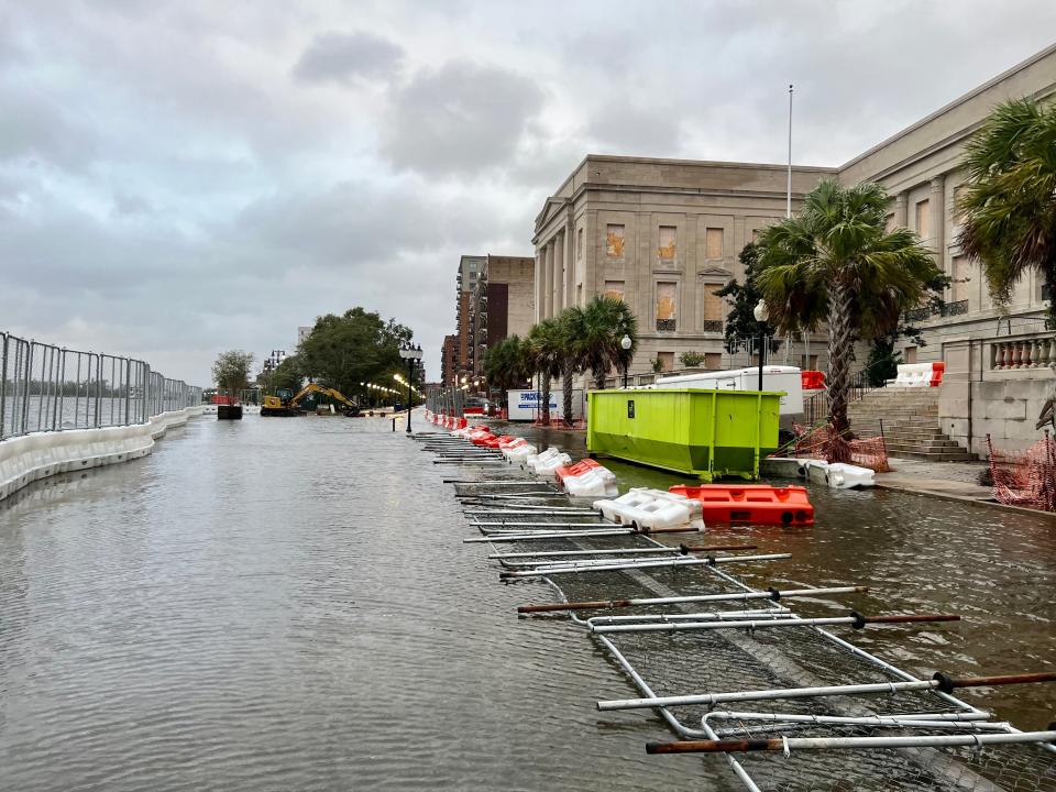
7:15 p.m.: Downtown Wilmington covered in debris
Hurricane Ian left sidewalks and roads in downtown Wilmington covered in leaves, twigs and small branches Friday evening.
The rain slowed to a drizzle and wind speeds dropped, proof that Ian was moving out of the area, but closer to the Cape Fear River, roads remained inaccessible to vehicles.
Portions of Water Street were flooded, with standing water more than six inches deep in some areas. The Cape Fear River swelled and its strong current splashed water onto the Riverwalk.
City officials worked to clear a large branch from the middle of South Fifth Street near Market Street, and traffic was deterred from the area.
-- Jamey Cross
6:30 p.m.: Conditions improve in Brunswick
As Ian tracks further inland across northeastern S.C. as a post-tropical cyclone, conditions in Brunswick County continue to improve.
Strong winds and the isolated possibility of tornadoes are still a threat for the evening but are expected to diminish overnight. Officials however are monitoring potential coastal flooding during tonight’s high tide.
Tropical storm and storm surge warnings are still in effect in Brunswick County, though the hurricane warning has been canceled. A high surf advisory risk will be in effect until 2 a.m. Saturday and a high rip current risk will remain in effect until 10 p.m. tonight.
Power outage map:See Hurricane Ian-related outages in New Hanover, Brunswick, Pender
Conditions have allowed the Holden Beach Bridge to reopen, though it’s subject to closing again if winds are sustained at 45 miles per hour.
The Calabash River Bridge has been closed and is only open to local traffic. Officials will await a bridge inspection prior to opening the bridge to all traffic.
Ongoing power outages and downed trees will make travel hazardous tonight, according to the National Weather Service’s Wilmington office. Despite some progress, about 10,000 Brunswick County residents remain without power.
-- John Orona

6 p.m.: As Ian weakens, Cape Fear River remains under storm surge watch
Ian has been downgraded to a post-tropical cyclone Friday evening, according to an update from the National Hurricane Center.
The storm was located just northwest of Myrtle Beach, South Carolina as of 5 p.m. and is expected to move across central North Carolina by Saturday morning, weaken overnight and dissipate over western North Carolina or Virginia Sunday.
According to the update, the Cape Fear River is under a storm surge watch, meaning "there is a possibility of life-threatening inundation, from rising water moving inland from the coastline."
Several streets in downtown Wilmington near the river have flooded and are closed, including portions of Water, Princess, South Front and Greenfield streets.
Stories from the storm:Business as usual in downtown Wilmington as Hurricane Ian lands
Flooding, downed trees and some power outages were felt across New Hanover County Friday. According to a news release, the county expects to resume normal operations Saturday. County parks, Airlie Gardens and the Arboretum will be assessed Saturday morning and open to the public if safe, staff said.
-- Jamey Cross
5:35 p.m.: Ian downgraded to tropical storm
As Ian becomes downgraded to a tropical storm, the most severe impacts to Brunswick County are starting to subside, though storm surges, flash flooding and high wind threats continue.
Sunset Beach Police Chief Ken Klamar said there's no significant damage so far other than downed trees and beach debris. Water is starting to recede in the area but wind gusts up to 70 miles per hour make it unsafe to open the bridge.
Town officials are anticipating the causeway will be breached once again tonight during high tide. Fire Chief Paul Hasenmeier is placing an engine and crew on the island overnight, according to an update from town administrator Lisa Anglin.
Small areas of Sunset Beach have reported restored power, but the bulk of the 11,000 residents affected are still experiencing outages. According to the BEMC website, the timeline for restoring power is unknown. About 700 Duke Energy customers are also still affected.
Normal county operations such as libraries and convenience centers are expected to resume Saturday, Oct. 1. Friday curbside trash and recycling pickup, which was suspended, will also now resume Saturday. Brunswick County government offices plan to open to the public as usual on Monday, Oct. 3.
Officials are still urging residents to remain home and not try to survey impacts themselves.
-- John Orona
5:05 p.m.: Streets flood in downtown Wilmington
Water continues to accumulate in the Wilmington area, now forcing several downtown roads to close to traffic.
According to a Friday afternoon news release from the city, Water Street, and the intersection of Market and Water streets have flooded and are closed to traffic. Airlie Road is also flooded and closed. More closures could be on the way, according to the city.
Storm drain valves at Greenfield Lake Park and Silver Spring Pond were opened Friday, the city said, to increase the capacity for stormwater intake.
Essential employees are working Friday. The city is expected to resume normal operations Monday.
The Wilmington Fire Department assured the community it is prepared for any emergencies that could arise as a result of the storm. Still, the department urged the community to stay inside and avoid driving.
“We’re ready, but we’d prefer to not have the emergency happen in the first place,” the department said in a Friday Facebook post.
-- Jamey Cross
4:45 p.m.: Power outages high in Brunswick
The Holden Beach Bridge is closed as the area starts to see sustained winds above 45 miles per hour.
More than 10,000 Brunswick Electric Membership Corporation customers are now without power, representing 11% of the county’s total customers. The bulk of the affected areas have been concentrated around Calabash, Sunset Beach and Southport.
More than 600 Duke Energy customers in Brunswick County have lost power across 18 active outages.
A tree is down and blocking the road near the 700 Block of Seaside Road in Sunset Beach.
In Shallotte, flooding has affected Village Point Road near the Village Point Methodist Church. Flooding in the area has reached some parts of the Shallotte Riverwalk boardwalk.
Ocean Isle Beach resident Drew Yates said more than 4 feet of water has inundated surrounding streets. Yates said after 15 years on the island, this is the worst hurricane he's seen in terms of impacts to his home so far. He's without power now and fears the high tide near midnight could bring more flooding before things have cleared up.
-- John Orona
4:15 p.m.: More than 1,200 New Hanover residents without power
As Hurricane Ian made its third landfall in South Carolina, the Wilmington area is seeing the effects of the storm.
More than 1,200 New Hanover County residents are without power Friday afternoon, according to Duke Energy.
Primarily, outages have been reported in the Wrightsville Beach and Ogden areas. Wrightsville Beach has also reported flooding and several road closures due to the storm.
Power outage map:See Hurricane Ian-related outages in New Hanover, Brunswick, Pender
Repairs are underway, according to Duke Energy’s website.
The University of North Carolina Wilmington is maintaining close to normal operations Friday. According to a weather update on the university’s website, on-campus dining and recreation facilities are operating at normal hours Friday evening.
The university is encouraging students to keep their cell phones charged and avoid driving through standing water on or off campus.
-- Jamey Cross
4 p.m.: Hundreds in Pender without power
Pender County remains under a tropical storm warning Friday afternoon, according to the National Weather Service.
Hundreds are feeling the effects as Hurricane Ian made its third landfall in South Carolina. Currently, steady rain and wind speeds around 30 mph are affecting the county.
According to Duke Energy, hundreds are without power, with nearly 750 customers affected near Burgaw and the Northeast Cape Fear River.
A handful of Jones-Onslow Electric customers – around 30 – are without power Friday afternoon.
-- Jamey Cross
3:30 p.m.: Road conditions deteriorate in Brunswick
The Brunswick County Sheriff’s Office has been providing road conditions updates throughout the day.
The following roads are flooded: Polly Gully Bridge on St. James Drive in St. James, the 2000 block of Oxpen Road, the Calabash River Bridge at Beach Drive, Daws Creek near Funston Road, Village Point near Bill Holden Road, Sunset Harbor between Mill Harbor Pointe and Byrnes Way, the 1300 block of Village Point Road, and Cedar Landing toward Provisions in Holden Beach.
Holden Beach town officials are asking residents not to use water and sewer until further notice.
In Sunset Beach, water breached the Causeway earlier this afternoon, and Shoreline East by Azalea Circle is flooded. Drivers are asked to avoid these areas.
All towns are asking residents to stay off the roads and avoid going out, if possible.
More than 1,000 residents have lost power so far, including 900 Brunswick Electric Membership Corporation customers in the south and west part of the county and nearly 300 Duke Energy customers across 25 active outages. Assessments and repairs are underway, according to both companies’ websites.
In the southern beach towns, flooding has already affected several homes. In Ocean Isle Beach, canals on Goldsboro and Cumberland have been breached, bringing water into homes and garages on the island.
In Sunset Beach, mainland roads are being closed, including Shoreline Drive East at Stokes Drive. Town officials are also monitoring Shoreline Drive West in the Twin Lakes area and Sunset Blvd. North near Bill's Seafood as rain continues.
Oak Island, which declared a state of emergency at 2:30 p.m., is reporting the following roads are closed or have hazardous travel:
East Yacht Drive within several blocks of the Veterans Park area at NE 15th Street
SE 40th Street from East Oak Island Drive to East Pelican Drive
East Pelican Drive from SE 40th Street to SE 46th Street
Multiple locations of standing water on all of Beach Drive, Yacht Drive, and Ocean Drive
As water continues to wash into low-lying and beachfront areas, resident are asked to disconnect power to boat docks, unplug golf carts, LSVs, and EVs, and remove all loose material that may get washed away. Residents are also asked to stay off the roads.
-- Renee Spencer and John Orona
3 p.m.: Rising water closes several Wrightsville Beach roads
Water levels are rising across New Hanover County, and several roads have been deemed undrivable.
On Friday afternoon, the Wrightsville Beach Police Department closed the access area between Live Oak and Island drives, marking the area as “severely restricted due to high water,” according to an announcement on Facebook.
Sunset Avenue – between Waynick Boulevard and South Lumina Avenue – was also affected by rising water and closed to traffic, as was the roadway along North Lumina Avenue between Oceanic and East Charlotte streets, the department said.
Residents in homes along those areas are asked to shelter in place until the high tide subsides.
According to the police department, driving in high water can be dangerous. When cars pass through, water can be pushed into homes and businesses in the affected areas.
-- Jamey Cross
2:30 p.m.: Southport, Bald Head Island get effects of Ian
In Southport, the Cape Fear River had breached the bulkhead along Bay Street, filling the parking lot at Waterfront Park with water.
Southport Fire Chief Charles Drew said trees are down on Caswell Avenue and Hankins Drive.
Carin Faulkner, public information officer for the Village of Bald Head Island, also reported flooding in some areas of the island.
“Our guys that have been out surveying the last hour or so have reported road flooding at the intersection of Federal Road and Muscadine Wynd, making it impassable for the near future,” Faulkner said. “At the marina, boat Dock A and B are underwater, and water is over the sea wall in the marina.”
She added that while the village’s creek access was showing signs of storm surge, “the dock and kayak launch are still intact.”
The Bald Head Island Ferry service did not run Friday, and currently there are no power outages on the island.
-- Renee Spencer
1:30 p.m.: Sunset Beach bridge closing
Emergency officials are closing the Mannon C. Gore Bridge to Sunset Beach as water begins to breach the causeway to the island. Island canals have also breached the bulkheads in several areas making driving extremely dangerous, according to an update from town administrator Lisa Anglin.
Officials urge people to not attempt to drive around barricades or through standing water. The town has declared a State of Emergency.
-- John Orona
1 p.m.: Southeastern North Carolina under a tornado watch
The National Weather Service has issued a tornado watch for New Hanover, Brunswick and Pender counties until 10 p.m. Friday.
A watch means the conditions are right for a tornado to happen in the area, but doesn’t mean one will necessarily occur. A tornado warning, on the other hand, means a tornado has been spotted or indicated by weather radar.
The area could see tornadoes and isolated wind gusts up to 70 mph, according to the weather service.
Meanwhile, southeastern Brunswick County already experienced a tornado warning earlier in the day.
And Southport Fire Chief Charles Drew said the city has now closed several streets due to flooding, including Short Street, and Bay Street at the intersection of Lord Street. He added the Yacht Basin Drive is now completely submerged.
“We have a lot of ponding on streets,” he said and urged drivers to stay off the roads if possible.
Drew also checked the Caswell Beach fire district, which is served by the City of Southport.
“A lot of Caswell Beach Road is flooded,” he said.
-- Emma Dill and Renee Spencer
12:30 p.m.: Road conditions in Carolina Beach
Late Friday morning, Carolina Beach officials closed two roads on the town’s northern end due to flooding.
Carolina Beach Mayor Lynn Barbee said the town opted to close Canal Drive and Carolina Beach Avenue N. because they were experiencing “some overwash.” Those who live along the streets will be able to access their homes, but others who drive around the barricades could risk a $250 citation, according to a post on the town’s Facebook page.
“We’re just trying to keep the sightseers away,” Barbee said.
Barbee said it’s unclear when the water will start to recede. High tide peaked in the area around 11:30 a.m. Friday, but storm surge and wind gusts have kept water levels high. “It’s kind of a battle between gravity, the tides and winds,” Barbee said.
Carolina Beach is seeing a few spotty power outages. Barbee said his own power flickered off and on a few times Friday morning. Duke Energy’s outage map shows about 200 homes are without power in Carolina Beach in an area along Lake Park Boulevard S. between Lake Drive and Hamlet Avenue.
Barbee said the town is prepared for coastal flooding and monitoring wind speeds.
Those winds will determine whether the town needs to close Snow’s Cut Bridge, the span linking Pleasure Island with mainland New Hanover County. If the area sees sustained winds of 45 miles per hour they will close the bridge, Barbee said. Barbee doesn’t expect the bridge to close, but the town’s fire chief is monitoring the winds just in case.
-- Emma Dill
Noon: Blustery conditions spread across Brunswick County
Brunswick County’s beaches saw higher than normal tides just before noon.
Holden Beach Mayor Alan Holden was looking out the window at the Intracoastal Waterway.
“It’s a couple feet higher than a normal high tide,” he said. “But I don’t anticipate any severe consequences from this storm.”
Around 11:45 a.m., Holden said all the town’s utilities were functional, and the bridge remained open.
“It’s just a blustery day,” Holden said. “We’re just going to hunker down here.”
He did say he hoped the tide didn’t rise another foot, but he’s also grateful things aren’t worse.
“I’m just very thankful that we’re in the condition we’re in compared to what could have been,” Holden said.
In Southport, the city is reporting several road closures due to flooding. They include the Yacht Basin loop roads: West Moore Street, Yacht Basin Drive, Caswell Avenue, and West Bay Street. Drivers are asked to avoid these areas. There are also two reports of downed tree branches: one on Bay Street and one on Turtlewood Drive.
-- Renee Spencer
11 a.m.: Travel becoming hazardous in Brunswick County
The Brunswick County Sheriff’s Office has reported that a tree is down in the 1700 block of Greenhill Road, and ponding and flooding is occurring on some roadways, including along West Bay Street and Yacht Basin Drive in Southport.
Other reports on road conditions include a tree blocking part of Lanvale Road near U.S. 17 around 10:30 a.m.
Brunswick County officials remain vigilant as Hurricane Ian approaches.
“As of now we are still waiting for final landfall,” said Brunswick County Emergency Services Director Ed Conrow, in an email. “We should start seeing winds increase and potential storm surge on our beach towns. We have resources staged and ready to respond.”
The Town of Holden Beach has become the latest Brunswick County municipality to declare a state of emergency. An update on the town’s website notes that current conditions include winds gusting to 36 mph with sustained winds at 30 mph. The wind is out of the northeast, and an inch of rain has fallen so far.
Conditions are expected to deteriorate throughout the afternoon, with high tide occurring around 11:30 a.m. In Holden Beach, storm surge is expected to reach the dunes, but canals and waterways remain normal at this time.
While the Holden Beach bridge remains open, the town will close it with 45 mph sustained winds. All utilities remain operational at this time, but the update notes that is “subject to change as conditions may vary.”
The Town of Sunset Beach also provided an update on conditions at 10:15 a.m. saying “public safety officials remain confident that the Causeway will be breached in the coming hours.” They also caution that the Mannon C. Gore Bridge will close is sustained winds reach 50 mph.
10:45 a.m.: Winds pick up, New Hanover ABC stores closing early
Wind gusts had picked up and rain began pooling on New Hanover County roads on Friday morning.
As of 10:15 a.m. Friday, there were no road closures in the area, according to Steve Still, director of New Hanover County’s Emergency Management, but water had started to cover roadways notorious for flooding, including New Centre Drive, Racine Drive and the Battleship North Carolina parking lot.
“Our traditional spots in the county are having issues,” he said.
As coastal areas reach high tide around 11:30 a.m. Friday, Still said beach communities can expect to see high water impacts. “When we have that storm surge push mid-afternoon into late evening, we’re going to start to see some water over the roadways in those areas,” he said.
Areas along the Cape Fear River, including Water Street, could be subject to flooding during high tide, which is expected downtown around 1 p.m. Friday. Still said he hopes the impact of the flooding is minimal but he’s in contact with a hydrologist at the National Weather Service’s Wilmington office to monitor the flood risk as the storm’s track and speed shift.
In addition to rain, Still said he’s received reports of 50-mile-an-hour winds near Federal Point in southern New Hanover. Still urged residents to stay home, if possible, and to avoid driving on flooded roads.
“Now’s not the time for joy riding or to go drive around to see what’s happening,” Still said. “If you don’t have a reason to be on the road, please don’t.”
New Hanover’s Emergency Operations Center opened at 7 a.m. Friday and will remain open until the storm leaves the area.
Also on Friday, ABC stores in New Hanover County are set to close early due to the impacts from Hurricane Ian. Stores are set to close at 3 p.m. Friday. ABC stores will reopen at 10 a.m. on Saturday, according to a news release from the New Hanover County ABC Board.
-- Emma Dill
10 a.m.: Heavier rain and wind bands moving into Brunswick County
Rains are becoming heavier and winds are picking up across Brunswick County.
The Town of Belville has declared a state of emergency. According to a news release, Belville Mayor Mike Allen signed the declaration earlier this morning and is requesting that “residents, property owners, boating interests and construction sites make preparations in securing their property.”
Belville Town Hall will be closed Friday, but essential personnel are on staff to serve the citizens.
Brunswick County is also urging residents in parts of Caswell Beach and Sunset Beach to conserve water during the storm.
A news release from the county noted Brunswick County utility customers being services by the vacuum sewer systems on Caswell Beach (residents at 104 through 713 Caswell Beach Road) and the island portion of Sunset Beach “may experience periods of limited or no service due to potential storm surge from Hurricane Ian.” The release states conserving water and limiting demands on wastewater can help “avoid sewer system backups from Friday morning through early Saturday morning.”
To conserve water, residents should refrain from: washing clothes, running dishwashers, and taking lengthy showers. All customers are encouraged to ensure they have a working backflow device in their plumbing draining system.
The City of Boiling Spring Lakes also declared a state of emergency late Thursday afternoon. City hall and town offices are closed Friday and will re-open Monday.
-- Renee Spencer
9:30 a.m.: Pender County, towns declare states of emergency
Pender County and the towns of Burgaw, Topsail Beach as well as Surf City have all declared states of emergency Friday morning. The county's emergency operations center has partially opened in response to Hurricane Ian.
As of 9:30 on Friday morning, the county's emergency operations center hadn't received any reports of flooding. Emergency responders hadn't received any weather-related calls for service as well.
Officials described conditions around the county as "just another rainy morning" with steady rain and sustained winds of approximately 20 mph, with gusts up to 35 mph. County officials are asking residents to stay alert and avoid driving if possible. Residents living in areas vulnerable to storm surge or flooding are asked to stay aware of conditions.
-- Matthew Prensky
9 a.m.: Oak Island experiencing typical flooding so far
While rain has been falling across Brunswick County since Thursday evening, the Town of Oak Island is not experiencing significant flooding.
“So far, it’s just the usual amount you see with a really heavy rain,” said Mike Emory, the town’s spokesman.
He added some areas of Beach Drive are known to flood, and those areas are experiencing “minor ponding and pooling” at this time. So far, he said, the town has not experienced any storm surge inundation. Any storm surge flooding will likely occur at high tide, which is around 11:30 a.m.
At this time, the town has not declared a state of emergency or opened its emergency operations center. While town hall and public facilities are closed today, Emory said they do have central staff working to address any storm-related needs.
“We’re keeping a network of key individuals in place to activate whatever response is necessary,” he said.
Emory encouraged citizens to keep up with any Hurricane Ian-related updates at the town’s designated webpage, noting that any updates and town response will be posted there.
-- Renee Spencer
8:30 a.m.: Southport declares state of emergency
In Southport, city officials say they would “rather be safe than sorry.”
Fire chief Charles Drew said that’s why the city moved forward with a state of emergency declaration around 5 p.m. Thursday and has partially opened its Emergency Operations Center at Fire Headquarters.
“We just want to be on the safe side,” Drew said.
Drew hasn’t heard any reports of flooding or road closures around 8 a.m., but he anticipates that will happen later this morning as the storm moves closer.
“We will see what happens this morning,” Drew said.
High tide will be around 11:30 a.m., and that’s likely when the Southport area will see the most significant impacts from flooding and storm surge.
The storm is expected to make landfall between Charleston and Myrtle Beach. This means Brunswick County will be on the northeast quadrant of the storm—the side associated with the strongest winds and thunderstorm activity.
Drew said the area is expecting 65 to 75-mile-per-hour winds, and storm surge of 6 feet, but he adds that much of that depends on exactly where the storm makes landfall. He adds the most important thing citizens can do right now is to “stay off the roads, stay home, and stay safe.”
-- Renee Spencer

7:30 a.m.: Flooding expected for Brunswick coast, downtown Wilmington
Hurricane Ian is expected to make landfall around 2 p.m. today between Charleston and Myrtle Beach. As the storm approaches the Carolina coast, it has continued to shift to the east – a move that’s brought the storm closer to Southeastern North Carolina than initially expected.
The track has the potential to shift between Friday morning and when the storm makes landfall, but that shouldn’t significantly change the weather conditions expected in the Cape Fear region, said Jordan Baker, a meteorologist with the National Weather Service office in Wilmington.
“Any slight nudges won’t really change anything,” he said.
Wind gusts and steady rain are being seen across the Cape Fear area, Baker said.
“We’ve got quite a bit of wind out there,” he said. “We’ve been in the envelope of the tropical storm force winds for a while now and they’re starting to increase.”
As of 7:15 a.m. Friday, the weather service office hadn’t received any reports of weather-related damage. The office, which is located near Wilmington International Airport, has gotten 1.5 inches of rain – a number they expect to climb steadily throughout the day.
In a Friday morning Facebook post, New Hanover County Emergency Management urged residents to limit travel Friday, stay off the beach and prepare for power outages caused by heavy rain and wind. The agency also reminded residents to slow down and move over for emergency vehicles responding during the storm’s impacts.
Baker said meteorologists are closely monitoring conditions along the coast in southern Brunswick County since the area will be the closest to Hurricane Ian and its impacts.
Both coastal Brunswick County and downtown Wilmington are expected to see flooding at high tide today. The Cape Fear River in downtown Wilmington could see more than 7 feet of water rise at high tide, which will occur around 1 p.m. and 1:21 a.m. today.
-- Emma Dill
3 a.m.: Sunset Beach requests residents and visitors evacuate the island
As Ian churns off the coast, some strengthening is expected. And landfall could occur between Charleston and Myrtle Beach, bringing hurricane conditions to Southeastern North Carolina.
Rain and wind were blanketing the Cape Fear region during the night. At 11 p.m., Ian was located 290 miles south-southwest of Wilmington and 240 miles south of Myrtle Beach.
A storm surge warning has been issued for coastal Brunswick County, prompting Sunset Beach to recommend evacuation.
A notice posted on the Sunset Beach Fire Department Facebook page said: "Public Safety officials are concerned that the Causeway could be breached due to the anticipated storm surge of two (2) to four (4) feet coupled with the high tide tomorrow morning. High tide is at approximately 11:30 AM on Friday, this means that the Causeway could be impassible for up to two (2) hours before and after high tide or 9:30 AM to 1:30 PM. During this timeframe, fire, police and EMS personnel may be unable to respond to calls on the island during this breach. Residents and visitors on the island are requested to evacuate to the mainland prior to this potential breach."
8 p.m.: Ian turns toward the Carolinas
Hurricane Ian was upgraded to a Category 1 storm as it turned toward the Carolinas Thursday afternoon. The National Hurricane Center is predicting Ian will make landfall near Charleston, S.C. on Friday afternoon.
The latest briefing from the National Weather Service office in Wilmington forecasts winds will start to pick up Friday along with storm surge, especially with high tide around 11:15 a.m. Friday.
The entire Cape Fear area remains under a severe weather warning, with Ian shifting in intensity between a hurricane and a tropical storm over the hours. Coastal areas in Brunswick County are under a Hurricane Warning while coastal areas in New Hanover and Pender counties are under a Hurricane Watch.
The National Weather Services predicts there’s a 80% to 95% chance tropical storm conditions will occur in Southeastern North Carolina. Tropical storm-force winds are expected to arrive during the early morning hours in coastal areas. The strongest winds are expected late Friday morning through Friday evening, according to the weather service.
Brunswick County along with areas of southern New Hanover and western Pender counties can expect to see winds between 58 to 73 miles per hour. The rest of the Cape Fear region can expect wind gusts between 39 and 57 miles per hour.
The high winds could result in damage to siding, awnings, tree limbs and other unsecured objects. The National Weather Service recommends all storm preparations take place tonight before the bulk of the storm’s impact hits the Cape Fear area, starting early Friday.
-- Emma Dill
6 p.m.: Weather warnings intensifying
As remnants of Hurricane Ian head toward the Carolina coast, more warnings have been issued by the National Weather Service for the Cape Fear area.
A 5 p.m. advisory from the weather service, issued a Tropical Storm Warning for an area of coastal North Carolina that includes Brunswick County. The warning extends from the Little River Inlet – near the border between North Carolina and South Carolina – to the Cape Fear River, according to the advisory. The warning is an upgrade from the Tropical Storm Watch that blankets the rest of the Cape Fear region.
A storm surge watch has also been issued for the Cape Fear River.
Despite the area’s Tropical Storm Watch, city of Wilmington offices expect to remain open to the public on Friday and, as of 5 p.m. Thursday, city officials don’t anticipate declaring a state of emergency, according to a news release.
However, city staff have worked to prepare for wind and rain from the storm by cleaning storm grates, clearing trees and other yard debris and performing maintenance checks on equipment needed for storm response.
City staff are prepared to deploy pumps in flood-prone areas and have pre-wired more than 200 intersections to allow traffic signals to run off of generators in the event of an outage.
-- Emma Dill
4 p.m.: Governor urges preparation, caution
In a Thursday news conference, Gov. Roy Cooper urged North Carolinians to prepare for the wind and rain that’s expected from the remnants of Hurricane Ian.
“For North Carolinians, I want to be clear, this storm can still be dangerous and even deadly,” he said.
Speaking from the state’s emergency operations center in Raleigh, Cooper reminded people that just over a year ago the remnants of Hurricane Fred caused six deaths and damage to about 125 homes in the western part of the state.
Cooper encouraged residents in all parts of North Carolina to prepare for potential power outages by stocking up on non-perishable foods, bottled water and making sure they have access to flashlights, batteries and other necessary supplies.
William Ray, North Carolina’s director of emergency management, added that he doesn’t expect to see widespread power outages, but isolated outages could occur due to high winds.
As Ian's track continues to fluctuate, Ray said he expects North Carolina will see the bulk of the storm’s impact throughout Friday.
Eric Boyette, North Carolina’s Secretary of Transportation, said the N.C. Department of Transportation will be monitoring road conditions during the storm. Both Boyette and Cooper urged citizens not to drive on flooded roads.
“Don’t take the chance. If a road is flooded, turn around,” Cooper said. “If you can’t see the pavement beneath the water then there’s likely a problem.”
-- Emma Dill
2 p.m.: Surf City prepares for storm
Although Hurricane Ian has left the state of Florida, it’s set to make landfall on the South Carolina coast Friday as a weaker category 1 storm, leaving the potential for damage in the Wilmington area.
The National Weather Service office in Wilmington has placed Southeastern North Carolina under a tropical storm warning with a 55% to 75% chance the area will see tropical storm conditions. The forecast also puts coastal parts of New Hanover, Brunswick and Pender under a storm surge watch. The “time of most concern” is Friday morning through Friday night.
Town officials are warning that some roads may become "impassable" and urge people not to drive over the Surf City Bridge if wind speeds exceed 45 miles per hour over a two minute period.
The emergency operations center in Surf City is activated at a level 3, which means it's staffed and ready to go. The town will be moving towards level 2 with partial staffing of key positions. Surf City expects four to six inches of rain and between two to four feet of storm surge.
"Anyone who drives over the Bridge while these conditions are present will be doing so at their own risk," according to a Facebook post from the town.
Coastal towns in the Wilmington area braced for impact Thursday afternoon. Along Canal Drive in Carolina Beach, some flooding had already started as rain began to fall just after 2 p.m. Road closure signs were set up along the street as the town prepared for Tropical Storm Ian to move in throughout the afternoon and evening.
North Carolina Gov. Roy Cooper along with state-level emergency management officials will hold a news conference at 3 p.m. Thursday to provide updated information on the severe weather. A live stream of news conference can be viewed here: https://www.ncdps.gov/news/news-conference-live-streams
On Wednesday, Cooper declared a state of emergency ahead of the storm. The declaration activates the state’s emergency operations plan, waives transportation rules to help with the transport of fuel and other critical supplies, and protects against consumer price gouging.
-- Emma Dill and Sydney Hoover
11:30 a.m.: Frying Pan Tower getting windy
While most of the Wilmington area is not expected to see deteriorating conditions connected to Tropical Storm Ian until later Thursday, some of the wind and rain has already shown up about 30 miles off the Brunswick County coast.
That's around the area of Frying Pan Tower, the iconic former U.S. Coast Guard light station that's now being restored by a host of volunteers.
Tropical Storm Ian:What to expect in Wilmington as tropical storm warning is issued
Frying Pan Tower reborn:Frying Pan Tower reborn -- Battle underway to restore famous offshore light station
It is running live video updates from the Facebook page of its deck and surrounding water, which has been choppy since Thursday morning.
During Hurricane Florence, those updates showed the American flag surviving through torrential rains and wind albeit sustaining some rips.
The flag remains up at Frying Pan Tower on Thursday morning.
-- Owen Hassell
11 a.m.: Belville prepares for Ian
According to a news release from Belville, it's likely it will receive some impact from Tropical Storm Ian as Brunswick County is now under a tropical storm warning.
Mayor Mike Allen and the commissioners request all residents, property owners, boating interests and construction sites make preparations in securing their property. All residents are advised to secure outdoor furniture, building materials, boats and any other objects that could blow around in high winds.
Cancellations, postponements:Tropical Storm Ian -- Cancellations, postponements and closings in the Wilmington area
“While we have been through stronger storms in recent years, we cannot let our guard down, become complacent, and avoid taking precautions,” Allen said. “There is nothing wrong with being overly prepared for any tropical system. It is my wish that everyone remains safe.”
Prepare:Tropical Storm Ian -- Wilmington area emergency officials asking public to prepare
Town officials are in constant contact with emergency management officials and the weather service and will provide you with updated information as it is received. Keep your vehicles fueled and familiarize yourself with locations of emergency shelters and the best possible routes to them. A list of shelters can be found at https://readync.org.
All residents with special needs are encouraged to register with the Brunswick County Emergency Services Department by calling 910-253-5383 or completing the special medical needs form online at http://www.brunswickcountync.gov/emergency/ems/. For emergency preparedness tips, you can also go to the town's website: https://townofbelville.com/emergency-information/.
-- Owen Hassell
This article originally appeared on Wilmington StarNews: Tropical Storm Ian live updates from Wilmington, flooding expected

