Tropical Storm Ian Live Updates: Increased uncertainty as storm track moves westward

8:00 p.m. | Very little change in Tropical Storm Ian as it aims for Florida's Big Bend area
The National Hurricane Center's 8 p.m. update shows little change to Tropical Storm Ian. The storm's path continues to aim toward northern Florida's Big Bend area, a significant shift west that leaves Sarasota and Manatee counties in the cone of uncertainty, but outside the projected path.
The NHC notes significant spread among the various storm prediction models, ranging from landfall in the north-central Gulf of Mexico to the west coast of Florida.
Stay up to date on the storm: Download the updated Herald-Tribune app
Hurricane Shelters: Where are Sarasota-Manatee hurricane shelters? When should I go?
"The latest NHC track forecast is once again adjusted westward, and further adjustments may be needed given the increased uncertainty in the day 3-5 period.," said the NHC in the latest advisory.
National Hurricane Center Tropical Storm Ian 8 p.m. update:
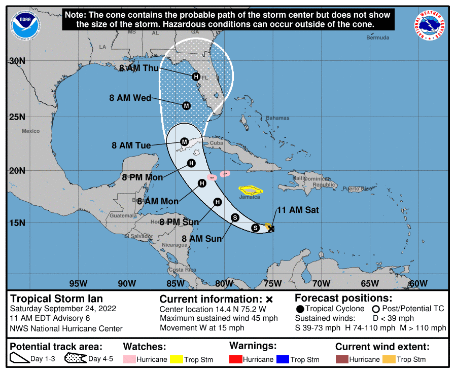
Location: About 230 miles S of Kingston Jamaica (14.3 N, 77W)
Maximum sustained winds: 45 mph
Movement: W at 14 mph
Minimum central pressure: 1002 mb
Next update at 11 p.m.

5:00 p.m. | Tropical Storm Ian's projected path moves farther from the Sarasota-Manatee area
According to the National Hurricane Center's 5 p.m. update, Tropical Storm Ian's track has shifted to the west, moving the center of the cone of uncertainty towards northern Florida and the Big Bend area. It is a dramatic change from Friday, when the Sarasota-Manatee area was seemingly the bullseye of the potential Hurricane Ian.
Sarasota and Manatee counties remain in the possible landing area of the potential Hurricane Ian, however, and meteorologists stress that there is still much uncertainty about the path of the storm.
Subscribe Now: Support the Herald-Tribune with a digital subscription
Tropical Storm Ian: Find all of our latest coverage of the storm
That said, several forecasters – including Ryan Truchelut, chief meteorologist at WeatherTiger – have spoken about how conditions seem to be pushing the storm's track further west.
National Hurricane Center Tropical Storm Ian 5 p.m. update:
Location: About 255 miles S of Kingston Jamaica (14.3 N, 77W)
Maximum sustained winds: 45 mph
Movement: W at 16 mph
Minimum central pressure: 1003 mb
Next update at 8 p.m.
2:30 p.m. | Manatee County declares a state of emergency in advance of possible Hurricane Ian
During an emergency Board of County Commissioners meeting this afternoon, Manatee County declared a local state of emergency in advance of Tropical Storm Ian.
“Our crews are getting ready to help support our residents and visitors through this storm’s impact,” said County Administrator Scott Hopes. “Now is not the time to panic. But it is time to finalize your storm preparations.”
Stay up to date on the storm: Download the updated Herald-Tribune app
Hurricane Shelters: Where are Sarasota-Manatee hurricane shelters? When should I go?
No Manatee County shelters have been opened, but any residents with special needs are encouraged to register with the county, to help meet the special needs of those who need assistance during evacuations and sheltering due to physical and mental disabilities.
Manatee County’s Emergency Operations Center will continue to add staff and resources in preparation for a higher-level activation as the storm progresses.
2:25 p.m. | What are the chances Sarasota-Manatee will be hit by the potential Hurricane Ian?
If you want to see a deep meteorological breakdown of Tropical Storm Ian, check out the latest column by Ryan Truchelut, chief meteorologist at WeatherTiger.
He has taken into account the latest information about the storm and has created four possible outcomes for where Ian will land:
Scenario 1: Keys and South Florida (5% chance)
Scenario 2: Southwest Florida (30% chance)
Scenario 3: North of Tampa and faster (35% chance)
Scenario 4: North Florida and slower (30% chance)
Subscribe Now: Support the Herald-Tribune with a digital subscription
Tropical Storm Ian: Find all of our latest coverage of the storm
"Overall, the shift south on Saturday morning tilts the odds more towards a westward track, but we are still in the timeframe in which more forecast surprises could happen," said Truchelut.
"While forecasters know more than we did 24 hours ago, we don’t know enough yet to confidently project who will get the worst of Ian and how bad it will be."

2:10 p.m. | Little change to Tropical Storm Ian in 2 p.m. NHC update
There were no surprises for Sarasota and Manatee counties in the 2 p.m. National Hurricane Center Tropical Storm Ian update, as the projected path of the storm remains centered just north of the Tampa Bay area.
The NHC forecasts that "the center of Ian is forecast to pass southwest of Jamaica on Sunday, and pass near the Cayman Islands Sunday night and early Monday. Ian will then approach western Cuba late Monday and emerge over the southeastern Gulf of Mexico on Tuesday."
Subscribe Now: Support the Herald-Tribune with a digital subscription
Stay up to date on the storm: Download the updated Herald-Tribune app
Hurricane Shelters: Where are Sarasota-Manatee hurricane shelters? When should I go?
Ian is also expected to "become a hurricane late Sunday or Sunday night and could be at or near major hurricane strength late Monday when it approaches western Cuba."
National Hurricane Center Tropical Storm Ian 2 p.m. update:
Location: About 270 miles SSE of Kingston Jamaica (14.2 N, 75.8W)
Maximum sustained winds: 45 mph
Movement: W at 16 mph
Minimum central pressure: 1003 mb
Next update at 5 p.m.
1:55 p.m. | Gov. Ron DeSantis expands state of emergency
Gov. Ron DeSantis on Saturday expanded a "state of emergency" to all 67 Florida counties in preparation for Tropical Storm Ian, which is expected to become Hurricane Ian in the coming days.
“The threat posed by Tropical Storm Ian requires that timely precautions are taken to protect the communities, critical infrastructure, and general welfare of Florida,” the governor said in his amended executive order issued Saturday afternoon.
1:50 p.m. | Sarasota-Manatee residents prepare for Ian
Although there is still uncertainty about the path of the storm, many area residents are taking the possibility of a major hurricane seriously.
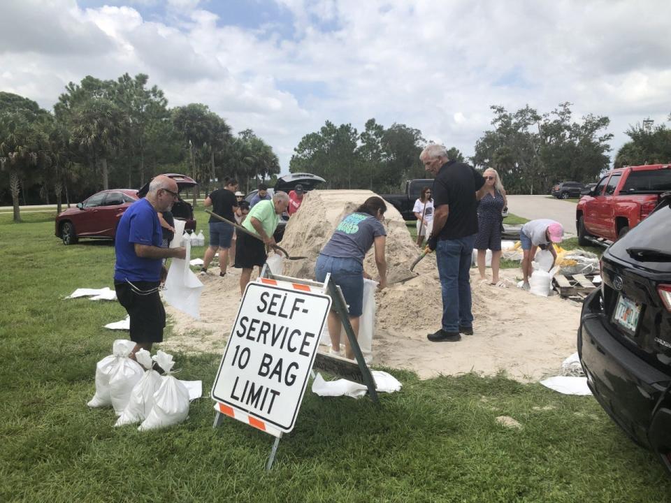
Manatee County began offering sandbags to residents on Saturday at seven locations across the county. At the self-service sandbag station at Bennett Park in Bradenton, dozens of residents picked up shovels, filled bags and tied them off before loading their cars.
Ken Paquin, 70, wiped the sweat off his brow before carrying two more bags to his trunk.
Tropical Storm Ian: Find all of our latest coverage of the storm
Hurricane Guide: What do you need to know before a big storm?
The Rhode Island native said it’s his first hurricane since he moved to the area 10 years ago. He’s been through some tropical storms, but nothing like this.
“It is what it is,” Paquin said. “There’s not much you can do about it. You gotta do what you gotta do.”
Maria Diaz, 48, also loaded sandbags into her car. Although she, her sister and her mom live separately from each other, they plan to ride out the storm together. Although they have plenty of food, water and flashlights, Diaz feels prayer is the most important form of preparation.
“The first thing I do is pray a lot, because everything is in God’s control,” Diaz said.
12:45 p.m. | Want a generator? It might be too late for this storm.
Herald-Tribune Political Editor Zac Anderson went searching for generators this afternoon and, as some might have predicted, didn't have any luck. Multiple Home Depot and Lowes locations are already sold out.
Lowe’s too pic.twitter.com/cdMyzQP23P
— Zac Anderson (@zacjanderson) September 24, 2022
Other supplies seem to be in better supply: Informal reports indicate that you can find gas without a wait at many stations and water is still available in many stores.
11:00 a.m. | Tropical Storm Ian's track shifts north, stronger storm expected
According to the 11 a.m. National Hurricane Center update, Tropical Storm Ian's track has shifted somewhat, with the center intersecting Florida north of the Tampa Bay area.
That shift comes as the NHC increases its expectation of Tropical Storm Ian's intensification, which promises a quicker transition to Hurricane Ian and increased strength.
"The NHC track forecast has been raised from the previous one, showing Ian becoming a hurricane by late Sunday and approaching western Cuba at or near major hurricane strength by Monday night," said the NHC. "Limited land interaction is expected as the cyclone quickly passes over western Cuba, and Ian is forecast to be a major hurricane over the eastern Gulf of Mexico on Tuesday and Wednesday as it approaches the west coast of Florida."
Tropical Storm Ian: Find all of our latest coverage of the storm
Hurricane Guide: What do you need to know before a big storm?
Currently, tropical-storm-force winds extend outward up to 60 miles from the center of Tropical Storm Ian. The Sarasota-Manatee area could experience tropical-storm-force winds as early as Tuesday morning.
National Hurricane Center Tropical Storm Ian 11 a.m. update:
Location: About 270 miles SSE of Kingston Jamaica (14.4 N, 75.2W)
Maximum sustained winds: 45 mph
Movement: W at 15 mph
Minimum central pressure: 1003 mb
Next update at 2 p.m.

8:00 a.m. | Latest update on Tropical Storm Ian from the National Hurricane Center
Little has changed in the National Hurricane Center's 8 a.m. update on Tropical Storm Ian. The storm's track still has the Sarasota-Manatee area in its center and it is predicted to impact Florida as Hurricane Ian late Wednesday or early Thursday.
According to the NHC, Tropical Storm Ian is expected to continue moving west/northwest through early Sunday, followed by a north-northwestward turn by late Monday. It will likely pass near Jamaica on Sunday, near or over the Cayman Islands Sunday night and then approach western Cuba on Monday. There is currently a Hurricane Watch in effect for the Cayman Islands and a Tropical Storm Watch for Jamaica.
More: Gov. Ron DeSantis declares 'state of emergency' for 24 counties for Tropical Storm Ian
Tropical Storm Ian: See spaghetti models, path and storm activity for Florida
Rainfall predictions range from 4-8 inches for jamaica and the Cayman Islands to 6-10 inches for Cuba.
Tropical Storm Ian is expected to become Hurricane Ian late Sunday.
National Hurricane Center Tropical Storm Ian 8 a.m. update:
Location: About 300 miles SSE of Kingston Jamaica (14.2 N, 74.5W)
Maximum sustained winds: 45 mph
Movement: WSW at 15 mph
Minimum central pressure: 1004 mb
Next update at 11 a.m.
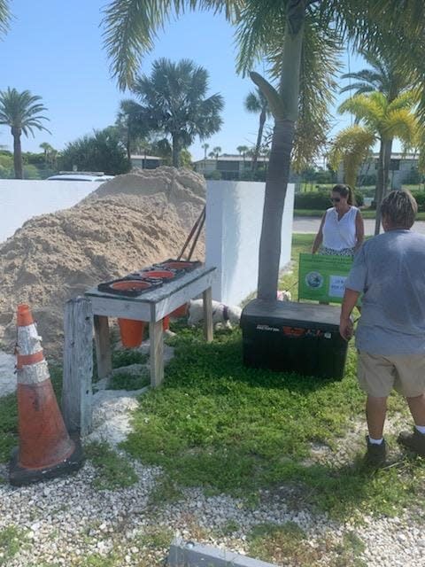
7:00 a.m. | Where can I get sandbags in Sarasota-Manatee?
Starting today, Manatee County will have self-serve sandbag filling at three locations:
Bennett Park, 400 Cypress Creek Blvd, Bradenton
Rubonia Community Center, 1309 72nd St. E., Palmetto
Myakka Community Center, 10060 Wauchula Road, Myakka City
JUST ADDED: Buffalo Creek Park, 7550 69th St E, Palmetto
Manatee County will also have three locations for picking up pre-made sandbags:
Manatee Beach, 4000 Gulf Drive, Holmes Beach (Northwest Parking lot)
Bayfront Park, 310 North Bay Blvd. Anna Maria (North end by the recycling center)
Coquina Beach, 2650 Gulf Drive, Bradenton Beach (South Bayside near the guardrail)
On Sunday, the county will also add full-service sandbag distribution at:
G.T. Bray Park, 5502 33rd Ave. Dr. W, Bradenton
Bradenton Area Convention Center, 1 Haben Blvd., Palmetto
All locations will be open from 9 a.m.-5 p.m.
The City of Venice Public Works Department will have sandbags available for residents beginning Sunday, Sept. 25, from noon to 6 p.m. at Wellfield Park off Pinebrook Road.
These are self-filling stations. There is a limit of 10 sandbags per household while supplies last and shovels will be provided. Residents are encouraged to bring their own bags in case the city runs out, as well as their own shovels to expedite the process.
Sarasota County will also begin sandbag operations Sunday, Sept. 25 from noon to 6 p.m. at three locations.
Ed Smith Stadium, 2700 12th Street, Sarasota.
Twin Lakes Park, 6700 Clark Road, Sarasota.
South County Fleet, 4571 SR 776/Englewood Road, Venice.
Shovels and bags will be available on-site, limit 10 sandbags per vehicle.
Sarasota's sandbag operations are also planned for Monday from 9 a.m. to 7 p.m.
The City of North Port will open a self-serve sandbag facility at the athletic fields behind the George Mullen Activity Center, 1602 Kramer Way. It opens at noon and bags, sand and shovels will be provided.
The Town of Longboat Key is planning to staff a sand and bag station at Broadway Beach Access on Sunday from 8 a.m. – 12 p.m. and again on Monday beginning at 8 a.m.
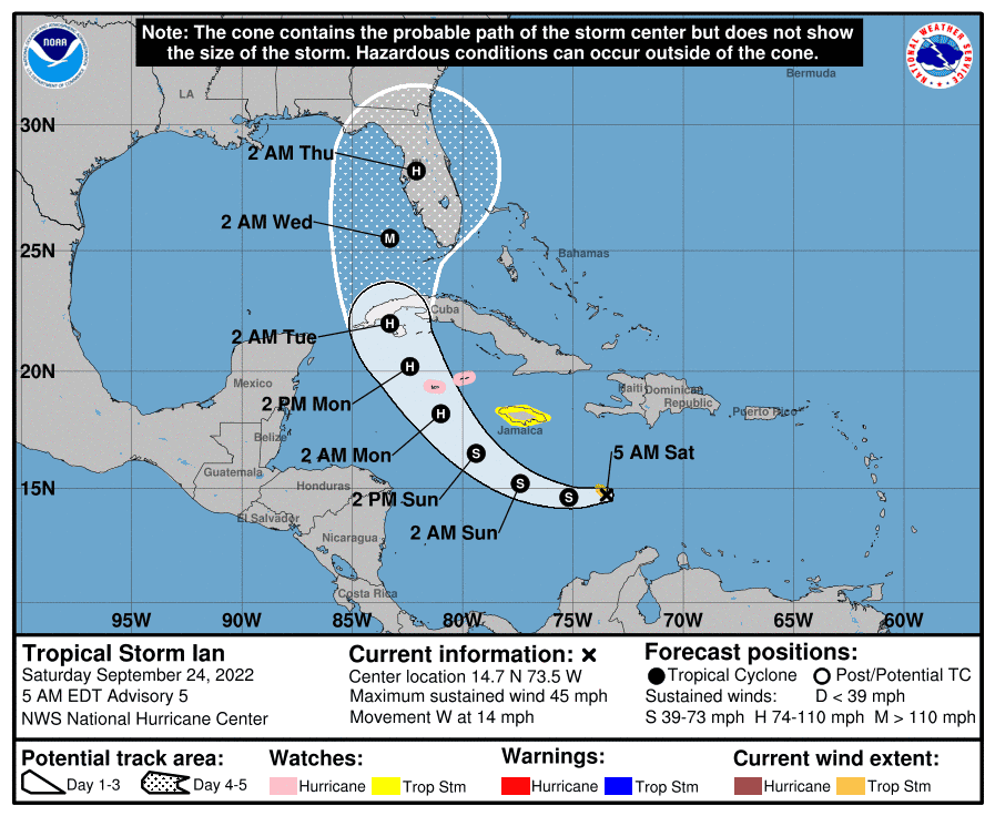
5:00 a.m. | Tropical Storm Ian's track remains focused on Sarasota-Manatee area
According to the National Hurricane Center's 5 a.m. update, Tropical Storm Ian has continued to strengthen as forecast, and Sarasota and Manatee counties remain at the center of its expected path.
The former tropical depression was upgraded to Tropical Storm Ian around 11 p.m. Friday night, and sustained winds are now 45 mph. The NHC forecasts that the storm will reach hurricane strength late Sunday.
The NHC expects the center of Tropical Storm Ian "to move across the central Caribbean Sea today, pass southwest of Jamaica on Sunday, and pass near or over the Cayman Islands Sunday night and early Monday."
If current predictions hold true, the storm would impact the Sarasota-Manatee area of Florida as Hurricane Ian late Wednesday or early Thursday. It is forecast to become a major hurricane – with winds above 110 mph – when it hits the warm waters of the Gulf of Mexico after passing over Cuba.
Gov. Ron DeSantis issued an executive order Friday declaring a "state of emergency" for 24 Florida counties – including Sarasota and Manatee – in the potential path of the coming storm.
National Hurricane Center Tropical Storm Ian 5 a.m. update:
Location: 315 miles SE of Kingston Jamaica (14.7N, 73.5W)
Maximum sustained winds: 45 mph
Movement: West at 14 mph
Minimum central pressure: 1003 mb
Will Hurricane Ian hit Sarasota-Manatee?
Though Tropical Storm Ian is not expected to become Hurricane Ian until late Sunday or early Monday, most of the predictive models show it impacting Florida near Sarasota and Manatee counties. However, forecasters caution that it is still too much uncertainty to have confidence in the storm track predictions.
"The track is still kind of uncertain," said Christianne Pearce, a meteorologist at NWS Tampa. "The center (of the storm) wobbles in the early stages. We're also not sure that it'll certainly make that turn towards Florida."
Tropical Storm Ian: Sarasota, Manatee county brace for potential Hurricane Ian
More: Gov. Ron DeSantis declares 'state of emergency' for 24 counties for Tropical Depression 9
When will Hurricane Ian hit Sarasota-Manatee?
If National Hurricane Center and other predictions hold true, the storm will steadily increase in intensity, becoming Hurricane Ian by Monday morning, and will impact Florida in the Sarasota-Manatee area at some point on Wednesday.
This article originally appeared on Sarasota Herald-Tribune: Tropical Storm Ian Live Updates: Path moves further from Sarasota area

