Live updates: Hurricane Ian and Brevard, how the storm will affect the Space Coast on Wednesday
Brevard County residents have endured band after band of Hurricane Ian throughout Wednesday.
Hurricane Ian, which became Category 4 storm overnight, is now marching its way into Florida on a diagonal pattern that will take the eye toward the northern Brevard/southern Volusia County line.
Check back with floridatoday.com throughout the day for all the latest updates.
And if you have a tip that would be helpful to your friends and neighbors here on the Space Coast, email Tim Walters at twalters@floridatoday.com.
Follow real-time updates below (manual refresh required):
Keeping you prepared during the storm is important to us. That's why we've lowered our paywall and made all of floridatoday.com available to you for free. Please support our journalism and our ongoing mission to keep Brevard informed by subscribing today at floridatoday.com/subscribe.
Find the outages: More than 1.1 million FPL customers lose power
5:10 a.m.: THURSDAY UPDATE
New day, new blog. To see all of Thursday's developments on Florida's space Coast, go to the link below.
Thursday's live updates: Hurricane Ian and Brevard, how the storm will affect the Space Coast on Thursday
10:08 p.m.: Cape Canaveral using pumps for streets
Cape Canaveral Mayor Wes Morrison said a temporary pump was being used to drain water away from the “Presidential Streets” area in the city’s southeast corner.
Morrison said that portion of the city is among the most prone to flooding and that the city was pursuing construction of a permanent pump.
— John McCarthy
7:09 p.m.: Shelters seeing more people arrive
Residents are getting nervous as Hurricane Ian ticks toward the Space Coast.
Three shelters are open, and they're starting to see more people arrive.
For more information on which shelters are open, see below:
'I'm nervous': Some Brevard residents hunker down for Hurricane Ian in county shelters
6:45 p.m.: 'Unprecedented rainfall' yet to come
Hurricane Ian could bring "unprecedented" rain and "near-record" flooding for portions of East Central Florida, the National Weather Service in Melbourne said during a Wednesday evening briefing with multiple county emergency operations teams.
Counties along and north of the hurricane's track, including north Brevard County, could see a "potentially unprecedent rainfall event," weather service officials said.
Officials warned of a 6- to 12-hour period of "extremely dangerous conditions" with "very high rainfall rates" and "damaging winds" across the region.
North Brevard, including Titusville, Mims and Port St. John, could see up to 18 inches of rain by the weekend, officials said.
A "considerable threat" of tornados, particularly in Ian's outer bands to the north and east of the storm center, will persist until about 1 a.m.
— Eric Rogers
6:33 p.m.: Reader tips
We've received some helpful tips from some readers. Here are two helpful tidbits from your friends around Brevard County.
Timm from Palm Bay advises people who don't have a better option to store important documents in their dish washer (provided it's been dried out). Timm says the dishwasher being air tight is a good place considering you don't want papers in your refrigerator or freezer in case of a power outage. Papers could get wet that way.
Robert suggest using Quick Dam products. He heard about them after Hurricane Irma. He says they are reasonably inexpensive, very light, easy to use and much easier than waiting hours for sandbags.
5:12 p.m.: Area transit shutting down
Space Coast Area Transit will stop fixed route transit service at 7 tonight. For those needing transportation to special needs shelters, call 211 Brevard before 7. There will be no service on Thursday. Follow @321Transit and Transit.com for more information.
— Jamie Groh
5:05 p.m.: Brevard Schools closing Friday
From BPS: All Brevard Public Schools and District offices will remain closed through Friday due to Hurricane Ian. All school activities, events and programs are also canceled for Friday and will be rescheduled if possible. District leadership will decide on weekend school activities as soon as possible.
More: Here is when Brevard HS football games are being rescheduled
4:58 p.m.: Evacuation orders to be localized
The county does not plan to issue any mandatory evacuations, but neighborhood-specific evacuations may become necessary in low-lying areas if flooding makes it difficult for residents leave their homes, especially in the northern part of the county.
"We might have to go in and pull people out if they're not able to get themselves out," said Don Walker, a spokesman for the county. "We don't have any neighborhoods pin-pointed where we may have to do that, but depending on what the rain does, it may be a possibility."
— Eric Rogers
4:53: Beachside fire and rescue update
Brevard County Fire Rescue continues to staff its beachside stations but will not easily be able to reach people in distress. The county is encouraging people to stay off the beach.
Hungry? Find an open restaurant
More: Most Space Coast restaurants closed for Hurricane Ian; these are still open
4:30 p.m.: Aldi opening delayed
The grand opening and ribbon-cutting ceremony for Aldi, 1539 W. New Haven Ave., West Melbourne, originally scheduled for 8:30 a.m. Thursday, has been rescheduled. The ceremony now has been set for 8:30 a.m. Oct. 6.
The store is part of the company’s aggressive nationwide growth in recent years, according to an Aldi press release. Aldi is on track to open 150 new stores and become the third-largest U.S. grocery retailer by store count by the end of this year. Hours for the new store are 9 a.m.-8 p.m. daily.
3:12 p.m.: Sign down in Indialantic
2:55 Cocoa Beach shelter-in-place request
The City of Cocoa Beach is asking residents to shelter in place as of Wednesday afternoon.
City officials said that flooding was the biggest threat with as much as 18 inches of rain possible. Mayor Ben Malik said that some flooding was already occurring throughout the city, such as along the State Road 520 frontage road. Officials asked residents to postpone doing laundry and otherwise conserving water so as not to overtax the sewage system.
Malik said that he had been told to expect winds of 35-50 mph with gusts up to 80 mph.
UPDATE: As of 6 p.m., flooding has affected Bicentennial Park, Belt Road and other side streets. Police and firefighters will cease services if winds reach sustained speeds of 45 miles per hour. — Finch Walker
2:50 p.m.: New Tornado warning for south Brevard
The National Weather Service issued a tornado warning for Osceola and southern Brevard County in effect at 2:32 p.m. until 3 p.m. Wednesday.
2:36 p.m.: Shelters have plenty of room
As of 2:30 p.m., 59 people and four pets have been logged into Brevard County's three hurricane shelters
The total capacity for these shelters is 1,856.
Shelters include:
Max K. Rodes Community Center, 3410 Flanagan Ave., West Melbourne.
Walter Butler Community Center, 4201 N Cocoa Blvd., Sharpes.
Wickham Park Community Center, 2815 Leisure Way, Melbourne.
— Ralph Chapoco
2:31 p.m.: Boil water notice beachside
Melbourne’s Public Works office shut off water to residents living along the 300-400 block of Port Royal Boulevard near Tortoise Island to repair a water main break.
A precautionary boil water notice has been issued for residents in the South Patrick Shores neighborhood. Residents should boil water before using for cooking, brushing teeth or washing.
Residents with questions should call Public Works at 321-608-5000.
— JD Gallop
2:20 p.m.: See who doesn't have power
Currently about 3,000 Brevard County residents are without power. You can track power outages at this link.
2:16 p.m.: Sheriff Ivey says stay home!
Curiosity killed the cat. It's a tough lesson to learn. Listen to your local officials and don't go out if you don;'t have to. Roads are washed out, nothing's open and there's no reason for you to be wandering about if you don't need to be.
Don't go out: Hurricane Ian advice from Sheriff Wayne Ivey: 'Stay where you're at' as weather conditions deteriorate
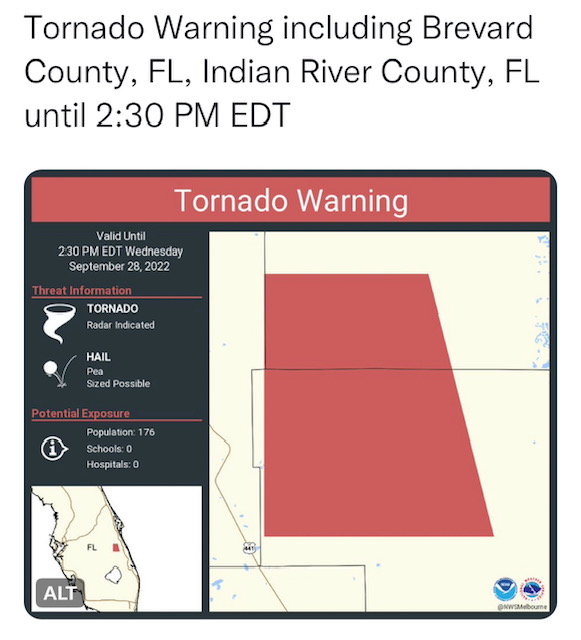
2:13 p.m.: Tornado warning for South Brevard
The National Weather Service issued a tornado warning for a portion of south Brevard and northern Indian River County until 2:30 p.m. A tornado warning means a funnel cloud has formed or has been spotted on weather radar.
2:10 p.m.: Fish out of water
Imagine you don't live near a body of water but this shows up on your driveway.
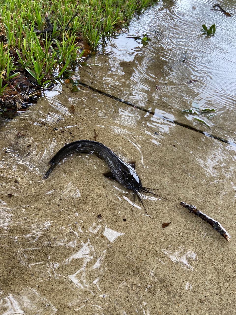
It happened for one family who lives in Melbourne not far from Wickham Park off Stewart Road.
Yes, it's a catfish, and no, it doesn't belong there.
FLORIDA TODAY's environmental stalwart Jim Waymer dshares his thoughts:
"It's likely one of these invasive catfish that tend to walk during these events. Think there's lots along St. Johns River basins."
He even provided evidence that this is a real thing.
Walking catfish? What's next? Flying alligators??
2:01 p.m.: One last restaurant meal before the storm
Ossorio Bakery & Café in Cocoa Village opened Wednesday morning for breakfast and lunch before closing early to wait out the storm. Managing partner Emma Kirkpatrick said they had a run on pastries and takeout in the morning, but things were slowing down around noon.
The Calvelli family from Merritt Island came in between rain bands for lunch and affogato, vanilla ice cream topped with espresso.

“So long as the roads are safe, we venture out,” said Donna Cavelli, as she enjoyed lunch with her sister, Nancy Cavelli; her daughter Racheal Calvelli-Loveland and Racheal’s fiancé, Byron Monzon-May.
A few more diners filtered in as the rain started again. The café’s wood-fired oven gave the place a cozy, ski-lodge feel.
Kirkpatrick said she hopes they don’t lose power. If all goes well tonight, Ossorio should reopen at 8 a.m. Friday.
— Suzy Fleming Leonard
2 p.m.: Instead of staring at the TV, watch KSC
Watch a live stream from Kennedy Space Center in Florida as Hurricane Ian, a powerful storm that's already brought significant rain to the spaceport, begins approaching the Space Coast.
Thanks for setting this up, Emre Kelly!
Live: Hurricane Ian impacts at NASA's Kennedy Space Center in Florida
1:54 p.m.: Info for post-storm help
For those seeking help post-storm: Crisis Cleanup is a collaborative disaster work order management platform which sets up a hotline for each storm, with damages posted on the dashboard from which work teams select projects.
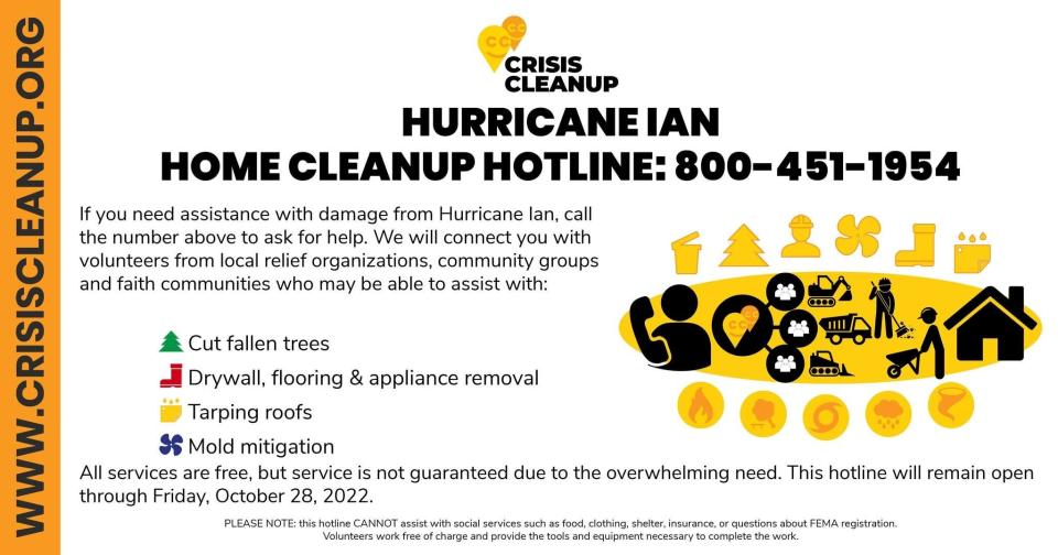
Here in Brevard, teams like the LDS Helping Hands come in after the storm and choose projects from Crisis Cleanup, said Keith Heinly, whose nonprofit, Case Management Services of Brevard, includes disaster case management among its services.
Click this link for Case Management Services of Brevard.
— Britt Kennerly
1:50 p.m.: Visually stunning hurricane tracker
Want to see the hurricane as you've not seen it? Click the link below and see what USA TODAY has come up with.
You realize just how small we are on this great big planet.
Hurricane Ian tracker: Where is powerful storm headed next?
1:32 p.m.: And then there were three
While many high school football games for Friday have been postponed or rescheduled, three are still on the schedule.
See who still hopes to take to the field Friday night in Brian McCallum's story below.
On the schedule: Multiple Brevard high school football games rescheduled so far
1:12 p.m.: Ocean Rescue suspended
Ocean Rescue and beach services were suspended at noon Wednesday in preparation of the incoming storm and will resume once conditions improve.
Swell associated with Ian will lead to dangerous rip currents and surf this week. A HIGH Risk of Rip Currents begins Wednesday and continues throughout the weekend.
1:10 p.m.: Update coming at 1:30 p.m.
At 1:30 p.m. today, Brevard County emergency management officials will give a live update on Hurricane Ian's approach to the Space Coast and what residents need to be aware of as the storm gets closer.
You can watch the broadcast on our floridatoday.com website here — Or on the Brevard County Emergency Management YouTube channel.
1:05 p.m.: Health First update
Health First is closing all business and medical offices at 2 p.m. Wednesday and they will remain closed through Thursday.
HEalth First's hospitals — Holmes Regional Medical Center, Cape Canaveral Hospital, Palm Bay Hospital, Viera Hospital — WILL REMAIN OPEN to provide emergency services.
Virtual care options are available to support our customers during this time. Please visit hf.org/virtual to get started.
More information is available at hf.org/hurricane for up-to-date hurricane news. If you are a Health First patient and have any medical questions or concerns, please call 321.434.3131.
12:44 p.m.: Here's what Brevard County can expect from Ian
Space Coast residents can expect Hurricane Ian — just shy of being a Category 5 storm — to quickly lose strength as it barrels its way across the state but not before lashing Brevard with tropical storm conditions by Thursday morning.
Brevard County, along with much of Central Florida, remains under a hurricane warning issued by the National Weather Service.
The National Weather Service in Melbourne says Brevard could see the outer bands of the storm pick up intensity between noon and 2 p.m. Wednesday, going into nightfall with intermittent showers.
Read J.D. Gallop's full story below:
11:54 a.m.: Community Credit Union Closure
Due to Hurricane Ian, all CCU Florida branches will be closing today, Wed., Sept. 28, at 11 a.m. and will be closed all day tomorrow, Thurs., Sept. 29.
As of now, normal business hours are scheduled to resume on Fri., Sept 30. Updates will be posted to CCU social accounts, website, and mobile app.
11:49 a.m.: NHC interactive map tool to check impacts near you
The National Hurricane Center has an interactive map with all active warnings and watches that lets you zoom in on your community to see the chance of different wind speeds.
NHC Interactive Map: Check here to see how winds may affect areas around you.
11:24 a.m.: Hurricane Ian's track as of 11 a.m.
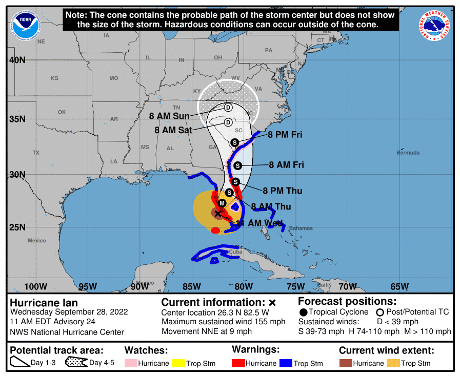
Brevard County remains firmly within the forecasted path of Hurricane Ian as of Wednesday morning at 11 a.m. Ian is expected to make landfall in southwestern Florida in the next few hours as a catastrophic hurricane. No changes were made to the track forecast near Florida, except to be faster.
Ian is likely to remain more intact as it crosses the Florida peninsula (due to both its stronger initial wind speed and its faster forecast forward speed), and this now increases the threat of hurricane-force winds on the east coast of Florida. This necessitates the issuance of a Hurricane Warning on the east coast of central Florida.
New with this advisory:
A Hurricane Warning has been issued from Sebastian Inlet, Florida northward to the Flagler/Volusia County Line, Florida.
A Hurricane Watch has been issued from the Flagler/Volusia County Line to the South Santee River.
11:08 a.m.: What's open/closed at CCSFS/PSFB
The latest statuses on facilities and amenities at the Space Coast's two military bases – Cape Canaveral Space Force Station and Patrick Space Force Base – as Hurricane Ian continues impacting Florida:
Full List: Statuses last updated by the Space Force at 10:30 a.m. EDT Wednesday, Sept. 28.
10:57 a.m.: S.C.A.T Regular Bus Routes Provide Shelter Transportation
Space Coast Area Transportation has regular bus routes that residents can take to get to any of the three County shelters that have opened for Hurricane Ian and for those who live in flood-prone and low-lying areas.
The routes are:
Walter Butler Community Center- Routes 1 and 11
Wickham Community Center- Routes 28 and 29
Rodes Park Community Center- Routes 20 and 25
Residents with special needs who need transportation to a shelter are asked to call 2-1-1 for assistance.
10:52 a.m.: Cape Canaveral declares State of Emergency
Wes Morrison, mayor of Cape Canaveral, said that a local State of Emergency was declared in the city and went into effect at 8 a.m. this morning. Declaring a local state of emergency gives power to the city manager and staff to protect the city manager and staff more quickly over the next seven days when the state of emergency expires.
10:49 a.m.: Grant-Valkaria reschedule
The town of Grant-Valkaria has rescheduled its town council meeting scheduled for Wednesday night at 7 p.m. to the same time on Monday, Oct. 3.
For more information and the agenda for the meeting, visit: https://grantvalkaria.org/meetings
10:43 a.m.: KSC prepares for Ian
At Kennedy Space Center, teams continued working on securing facilities, locking down loose items, and completing any work that needed to be done in advance of Ian's arrival and potential shutdown of the center itself. As of Wednesday morning, KSC was in HURCON II, which is issued 24 hours prior to sustained winds of 50 knots (57 mph).
A NASA ride-out team, or ROT, was expected to be stationed in the Launch Control Center, attached to the Vehicle Assembly Building, to stay there through the storm and keep an eye on critical infrastructure. The team is also responsible for the first wave of damage assessments after the storm clears.
More details at the link below by Emre Kelly:
Space activity updates: Kennedy Space Center, Cape Canaveral Space Force Station, and Patrick Space Force Base prepare for storm impacts and reschedule launches.
10:37 a.m.: Erosion expected
Ian's powerful push through Florida looks more poised to eat away at the banks of the Indian River Lagoon than at the Space Coast's beaches and dunes, forecasters say.
Only a three-foot surge is expected in Brevard, so Hurricane Ian is likely to spare local beaches, especially after all the recent renourishment projects to buffer properties. But because the Gulf Stream is closest to Florida this time of year, pooling up ocean water, the Indian River Lagoon level is heading into its highest time of year, so erosion might be more of an issue along the lagoon banks, testing sandy bluffs armored with rocks, concrete or just native plants.
For more, read Jim Waymer's story below:
Indian River Erosion: Erosion might be more of an issue along the lagoon banks
10:31 a.m.: Update expected at 1:30 p.m. today
At 1:30 p.m. today, Brevard County emergency management officials will give a live update on Hurricane Ian's approach to the Space Coast and what residents need to be aware of as the storm gets closer. You can watch the broadcast on our floridatoday.com website here — Or on the Brevard County Emergency Management YouTube channel.
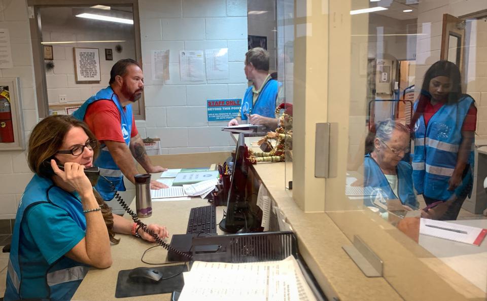
10:19 a.m.: Shelters are opening
Crews are seen setting up for the 10 a.m. opening at one of three shelters opening Wednesday in Brevard County. This Walter Butler Community Center shelter location is in the Sharpes area between Cocoa and Port. St. John.
9:33 a.m.: Visitor Complex is closed
Kennedy Space Center Visitor Complex will be closed Wednesday and Thursday.
During this closure, guests will not be permitted onto visitor complex grounds.
For the latest updates please continue to visit KennedySpaceCenter.com or Facebook and Twitter (@ExploreSpaceKSC).
9:15 a.m.: Football games called off
Hurricane Ian is causing schools around the state to call off Friday night football games, including in Brevard.
Several games have been cancelled or rescheduled.
To see which ones, click on Brian McCallum's story below.
Off the field: Multiple Brevard high school football games rescheduled so far
9:01 a.m.: Ian is a monster: 155 mph winds now
Hurricane Ian quickly intensified Wednesday morning and is now a catastrophic Category 4 hurricane.
It is expected to make landfall around Port Charlotte, which is just south of Sarasota.
For more, read here:
Fast expansion: Hurricane Ian grows into powerful Category 4 storm. Maximum sustained winds up to 155 mph
8:57 a.m.: Cocoa, Titusville declare States of Emergency
The cities of Cocoa and Titusville have declared a state of emergency.
Declaring a local state of emergency gives power to the city manager and staff to protect the city manager and staff more quickly over the next seven days when the state of emergency expires.
For more, read Tyler Vazquez's story below:
Precautionary measures: Hurricane Ian prompts local state of emergency declarations in Cocoa and Titusville
8:16 a.m.: United Way and post-storm recovery efforts
United Way of Brevard oversees and is the fiscal agent for the Brevard Long-term Recovery Coalition (BLTRC), which was created by United Way following the 2004 hurricanes.
The BLTRC works to strengthen area-wide disaster coordination long after storms have passed.
The BLTRC matches low-income residents to available resources helping them to return to safe and secure living conditions.
Pending post-storm community needs, the United Way will make the determination to activate the BLTRC to assist community members.
— Britt Kennerly
8:15 a.m.: More local info on Ian
Brevard County residents will experience rain for the next two days.
Here's what local officials are saying. Read JD Gallop's story here:
On its way: Hurricane Ian to cross state, potentially target Space Coast with near hit as tropical storm
8:07 a.m.: New 8 a.m. track just out
Brevard County is smack dab in the middle of Hurricane Ian's path as of 8 a.m.
The Category 4 hurricane will make landfall within the next few hours on the west coast around Sarasota.
It will march across the state diagonally, passing Orlando still with sustained hurricane force winds. The eye will exit the state near the Brevard-Volusia County border as a tropical storm.
However, the storm's size is such that it encompasses much of the state.
Rainfall totals could reach up to 15 inches in northern Brevard, and 10-15 inches in the rest of the county.
Ian's eye will pass over Atlantic waters and skirt the Jacksonville area before making landfall again in Central Georgia.
Check back throughout the day for more updates.
7:55 a.m.: Meals on Wheels delivery suspended
Deliveries of Meals on Wheels have been suspended through Thursday.
Officials from Aging Matters in Brevard, which administers the food program, will reassess on Thursday regarding Friday delivery, with safety for volunteer drivers of utmost concern, said Tom Kammerdener, acting president and CEO.
All Seniors at Lunch sites are closed until further notice.
— Britt Kennerly
7:53 a.m.: Know what's closed, which is most everything
There's no need to guess whether something is closed. We have all the info right here. Don't see something? Let us know and we'll try to find out.
Email twalters@floridatoday.com. I'll be here all week...
Shut down: What's closed, canceled in Brevard
7:50 a.m.: The Port is closed
Port Canaveral has closed, as the impacts of Hurricane Ian start to be felt along the Space Coast.
The closing will disrupt cruise and cargo operations there this week.
There are no cruise ships scheduled to be in port on Wednesday, but three Port Canaveral-based ships are scheduled to end and begin cruises on Thursday.
To see which are impacted, read Dave Berman's below.
Shutting down: Port Canaveral closes as Hurricane Ian approaches, which disrupts cruise operations
7:43 p.m.: Bad news for the Indian River Lagoon
No matter what degree of havoc Hurricane Ian leaves in its wake in Brevard County, what is certain is that the huge amount of rain heading our way will be enough to deliver more bad news for the Indian River Lagoon.
The heavy runoff from the storm will come as a blunt shock to an already overwhelmed estuary, with vastly shrunken seagrass beds and a weakened and dying manatee population.
Forecasters expect only a foot of storm surge, so beaches are likely to be mostly in the clear. But Ian's deluge — projected at up to 10 inches — could put already stressed manatees, dolphins and other lagoon life in peril, in the wake of a record sea cow die off.
Intense storms such as hurricanes are shocks to coastal ecosystems, says Duane DeFreese, executive director of the Indian River Lagoon National Estuary Program.
They can produce a whole cascade of stressful events that continue to have impacts for weeks, months and sometimes even years after the storm passes, he said.
Read Jim Waymer's story below.
More bad news for the IRL: Ian deluge sure to 'shock' Indian River Lagoon; heavy rain and runoff bad news for estuary
7:30 a.m.: Wondering what happened in the run-up to Ian on Tuesday?
Check out all of yesterday's news here:
Tuesday's updates: Hurricane Ian and Brevard, what will the storm bring and how will it affect the Space Coast
This article originally appeared on Florida Today: Wednesday live updates: Here's how Hurricane Ian is impacting Brevard

