Live updates: Impacts will be 'limited' in Tallahassee area as Cat. 3 Hurricane Ian eyes Florida
The Tallahassee Democrat is making this article free of charge for all readers in the interest of public safety. Consider supporting the Tallahassee Democrat with a digital subscription.
Here are the latest updates on Hurricane Ian. The storm strengthened into a major hurricane on Monday and continues to threaten much of the state. Florida's central west coast was bracing for the possibility of a direct hit.
QUICK LINKS
State level Hurricane Ian live updates: Live Updates: Hurricane Ian's path, predictions and Florida Gov. DeSantis' latest
Latest WeatherTiger forecast: Hurricane Ian: Three scenarios, with divergent levels of destruction to Florida
Practical tips: Expanded advice from a hurricane veteran to help you weather the storm
What's closed, delayed: Hurricane Ian: Here's what's open, closed and postponed in Tallahassee, the Big Bend
What local leaders are saying: 'Get through this together': Officials urge Tallahassee to be ready for Hurricane Ian
8:30 p.m. Impacts will be 'limited' as Tropical Storm Warning issued for Big Bend coastline
The Big Bend coastal counties of Franklin, Wakulla and Jefferson are now under a Tropical Storm Warning.
A Tropical Storm Warning is issued when sustained winds of 39 to 73 mph or higher associated with a tropical cyclone are expected in 36 hours or less. These winds may be accompanied by storm surge, coastal flooding, and/or river flooding.
While the National Weather Service Tallahassee stated that "confidence has grown that impacts for the tri-state area will be limited as Ian has tracked south," it noted that an expanded wind field means the southeast Florida Big Bend still has the potential for tropical storm force winds.
The latest forecast calls for widespread rainfall totals of 1.5 to 3 inches with locally higher amounts possible.
Storm surge watches have also been cancelled.
3:40 p.m. | Leon County Schools will remain open on Wednesday
The Leon County school district announced schools will remain open on Wednesday as Hurricane Ian threatens the southwest Florida coast. The district said it will give updates Wednesday on whether operations the following day will be affected by the hurricane.
Leon County Schools will be open Wednesday, September 28. After consulting with emergency management, shelters will not be opening on our campuses tomorrow which allows school to remain open. We will update tomorrow afternoon if there are any changes to school operations Thursday pic.twitter.com/RSawuBJMBp
— Leon County Schools (@LeonSchools) September 27, 2022
The district has seven schools that can serve as shelters. Leon County officials said Tuesday that the state has not requested any shelters for storm evacuees.
2:35 p.m. | Leon County Emergency Management remains at partial activation
Leon County’s Emergency Operations Center remained only partially activated on Tuesday. Kevin Peters, director of Emergency Management, said he did not expect impacts on a level of hurricanes that have hit the area in the recent past.
“During the next few days, we have the possibility for the bands of rain storms to come through and breezy conditions,” Peters said. “But at this point, no indication from the National Weather Service that sustained tropical storm force winds will occur in Leon County based on this latest forecast.”
Peters said state emergency officials have not requested any assistance yet from Leon County, including opening shelters. Leon County Schools Superintendent Rocky Hanna said Monday that seven schools, mostly high schools, would serve as shelters if needed.
“We have identified locations and resources that if a task comes from the state, we can coordinate with the school district if needed,” Peters said. “Counties in southwest Florida are opening additional shelters in their communities to provide safe places for their local residents to evacuate to.”
Gov. Ron DeSantis said in a news conference that as many as 2 million Floridians were under evacuation orders because of Ian. State emergency officials asked residents in southwest Florida to evacuate to southeastern counties rather than to the north.
1:40 p.m. | 'Extremely dangerous" Hurricane Ian could still bring high winds, heavy rain to Tallahassee
Though Hurricane Ian's forecast track continued to shift to the south and east, Tallahassee could see sustained winds between 30 and 40 mph and 3 to 4 inches of rain, with impacts arriving as early as late Wednesday and lasting into Friday.
However, those wind speeds and rainfall totals might not materialize depending on how much farther away the forecast track moves. On Tuesday afternoon, Tallahassee remained around the western edge of the cone of uncertainty.
“The storm has tracked a little bit more to the south and east and kind of nudged in that direction over the last 12 to 24 hours,” said Kristian Oliver, meteorologist with the National Weather Service. “That might shift our values down a little bit. It’s all track-dependent at this point.”
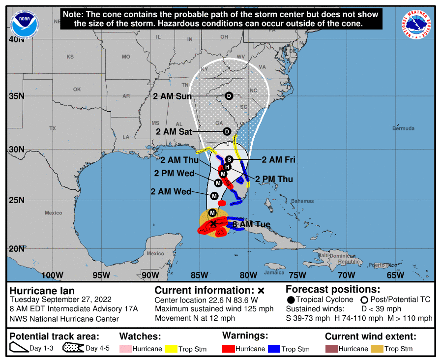
Ian made landfall in Cuba before re-emerging in the Gulf of Mexico with maximum sustained winds of 115 mph, according to the National Hurricane Center’s forecast as of 11 a.m. Tuesday. It was expected to make landfall Wednesday perhaps south of Tampa Bay as a major hurricane.
Though it’s expected to encounter increasing shear by Wednesday, Ian isn’t expected to “significantly weaken” by landfall, Hurricane Center forecasters said.
“The NHC intensity forecast continues to call for an extremely dangerous hurricane landfall for southwestern Florida,” the Hurricane Center said.
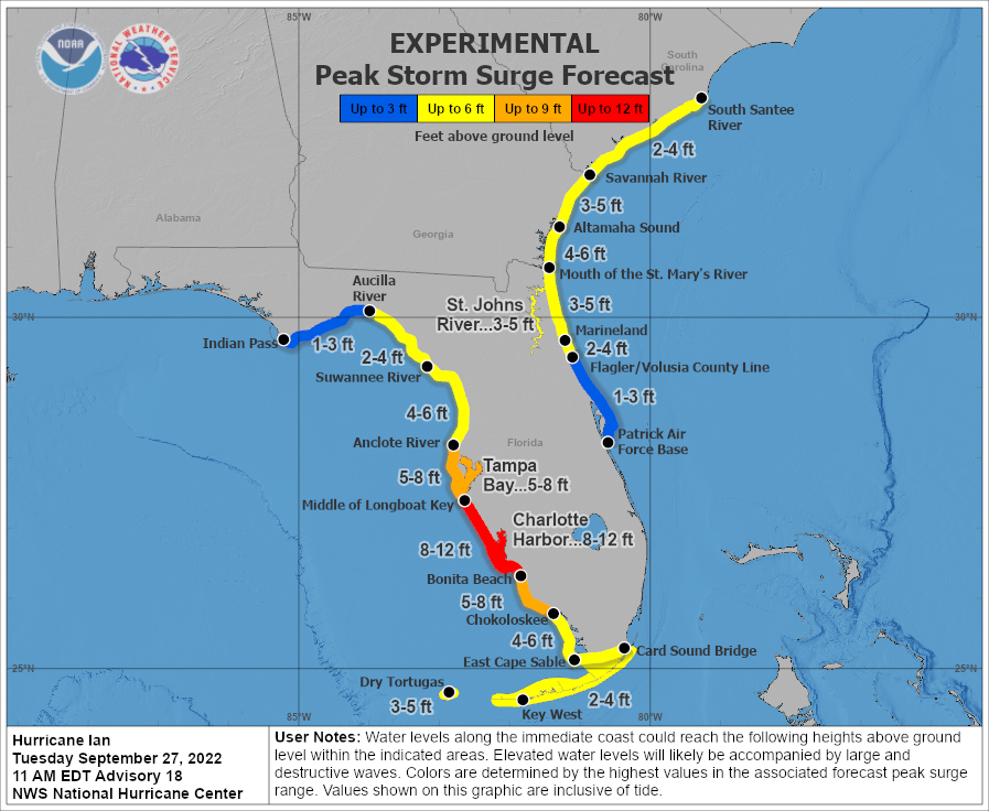
12:25 p.m. | Big Bend coastline could see surge
National Hurricane Center forecasters are advising residents in Franklin, Wakulla and Jefferson counties to prepare for 1 to 3 feet of storm surge as Hurricane Ian edges closer to the Florida peninsula.
From the EOC: Venice now looks like Florida landfall for shifting Hurricane Ian
12 p.m. | Tallahassee Democrat Paywall comes down as Ian threatens wide swath of Florida coast
To provide our community with important public-safety information during Hurricane Ian, the Tallahassee Democrat has temporarily suspended its paywall. Readers can access an unlimited number of stories on our site, regardless of subscription status.
More details: Tallahassee.com news is free, unlimited for Hurricane Ian
9:30 a.m. | Tallahassee 'not out of the woods' as a 'very large' Hurricane Ian approaches Florida's west coast
Hurricane Ian may make landfall closer to Tampa Bay than the Big Bend, but Tallahassee could still see tropical storm force winds and heavy rain as it meanders slowly north.
Ian, a Category 3 hurricane with maximum sustained winds of 125 mph, lashed the coast of Cuba early this morning. It’s forecast to strengthen over warm Gulf waters before making a second landfall Wednesday along Florida’s central west coast.
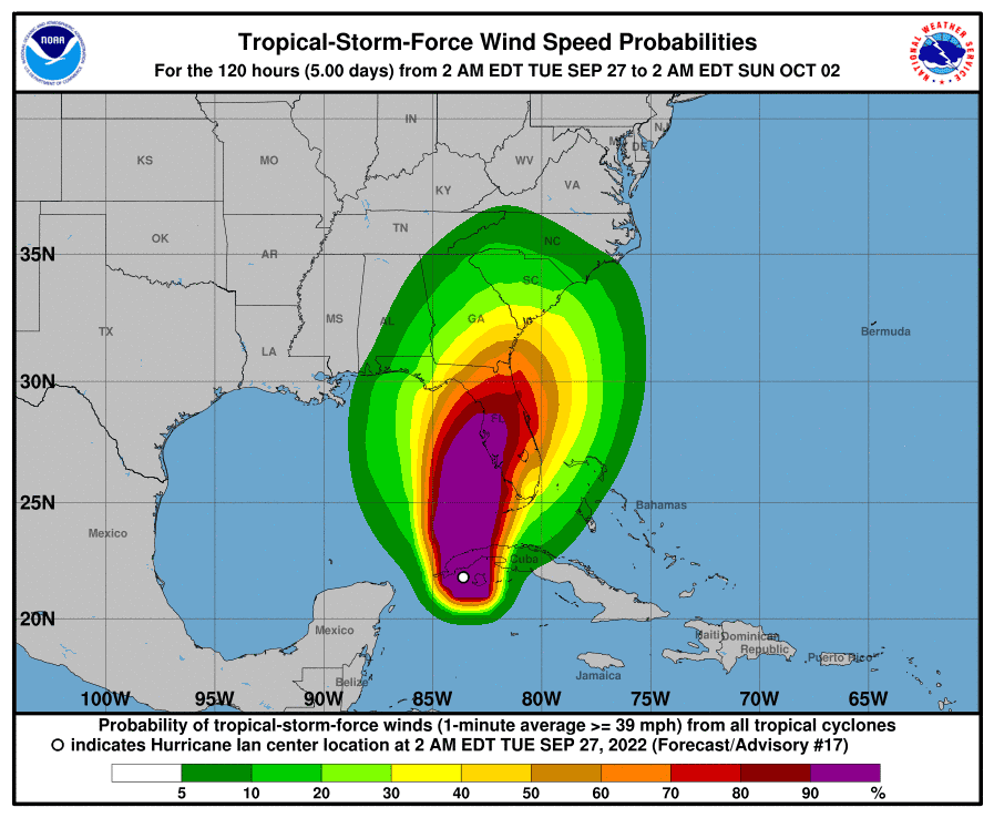
Parks Camp, meteorologist with the National Weather Service, said impacts from Ian, a large hurricane with an expansive wind field, will be felt well away from the center. And there’s still uncertainty about where it will go once it comes ashore.
“We’re not out of the woods yet,” Camp said. “If you look at our tropical storm force wind probabilities, they’re still fairly elevated because it’s slowing down. There’s still time for the tracks to get adjusted and for it to move back in this direction a little bit.”
The latest forecast track for Ian shows it moving over North Florida on Friday and into South Georgia by early Saturday morning. Camp said the main threats for Tallahassee are high winds and heavy rain.
“The risk of hurricane force winds certainly has dropped off, but we still have some risk of seeing tropical storm force winds as we move later into the week,” he said. “So that's kind of what we're keeping an eye on.”
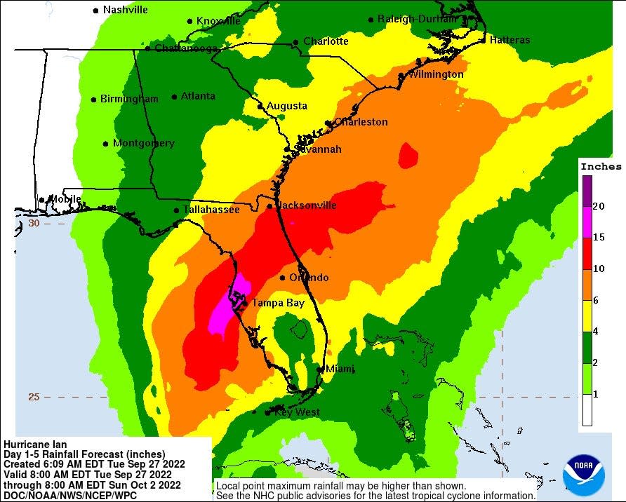
According to the latest rainfall forecast associated with Ian, the Tallahassee area could see as much as 2 to 6 inches of rainfall.
In the central and north Florida area, a hurricane watch is in effect from north of the Anclote River near Tarpon Springs to the Suwannee River. A tropical storm watch is in effect from north of the Suwannee River to Indian Pass south of Port St. Joe.
6 a.m. update | Hurricane Ian makes initial landfall in Cuba, barrels its way toward Florida's central west coast
Category 3 Hurricane Ian made initial landfall in Cuba this morning before barreling its way toward the Gulf of Mexico and Florida’s central west coast.
The National Hurricane Center in Miami warned that tropical-storm-force winds could begin lashing the central west coast as soon as tonight, with hurricane-force winds arriving by Wednesday morning.
“There is danger of life-threatening storm surge along much of the Florida west coast, where a storm surge warning has been issued, with the highest risk from Fort Myers to the Tampa Bay region,” the Hurricane Center said late Monday. “Residents in these areas should listen to advice given by local officials.”
The forecast track for Ian, which strengthened Monday into a major hurricane, continued to shift east, dimming chances of a direct hit along the coast south of Tallahassee. However, the Big Bend remains in the five-day cone of uncertainty with Tallahassee on its edge.
The Hurricane Center’s latest forecast track shows Ian coming ashore possibly around the Tampa Bay area on Thursday morning before moving inland and sweeping north across the Peninsula into eastern North Florida and South Georgia as a weakened tropical storm or depression.
As of 5 a.m., Ian was located about 175 miles south-southwest of the Dry Tortugas and moving north at 12 mph, the Hurricane Center said. It had maximum sustained winds of 125 mph.
A hurricane warning was issued for Bonita Beach to the Anclote River, including Tampa Bay.
A tropical storm warning was issued for the lower Florida Keys from the Seven Mile Bridge west to Key West, Flamingo to Bonita Beach, the Suwannee River to the Anclote River, the Volusia/Brevard county line south to Jupiter Inlet and Lake Okeechobee.
A tropical storm watch is in effect for coastal areas of Franklin, Jefferson, Wakulla and Dixie counties. A storm surge watch is in effect for coastal areas of Dixie and Taylor counties.
Contact Jeff Burlew at jburlew@tallahassee.com or follow @JeffBurlew on Twitter.
Never miss a story: Subscribe to the Tallahassee Democrat using the link at the top of the page.
This article originally appeared on Tallahassee Democrat: Live updates: Tallahassee area 'not out of the woods,' but will see 'limited' impacts

