Tropical storm warning issued for Charlotte area as Ian expected to deliver heavy rains
- Oops!Something went wrong.Please try again later.
The Charlotte area is under a tropical storm warning with Hurricane Ian expected to dump a deluge of potentially tree-toppling heavy rain on Friday afternoon.
Bands of rain are expected to arrive in the Charlotte area hours before the center of the storm is forecast to cross near the city, a National Weather Service meteorologist said Thursday.
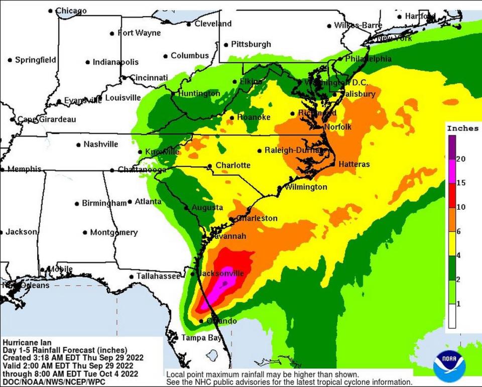
Ian could pack 20-30 mph winds with 60-mph gusts, strong enough to damage “porches, awnings, carports, sheds and un-anchored mobile homes,” according to the tropical storm warning issued at 11:17 a.m. Thursday by the NWS office in Greer, South Carolina.
Counties under the warning are Mecklenburg, Cabarrus, Catawba, Davie, Gaston, Iredell, Lincoln, Rowan and Union, and, in South Carolina, York, Lancaster and Chester counties.
Gusts could snap “many large tree limbs” and uproot shallow-planted trees, according to the warning.
Even more deeply rooted trees are susceptible to being knocked over during Ian because of soil weakened by the storm’s expected 4 inches to 6 inches of rain this weekend, Andrew Kimball of the NWS Greer office told The Charlotte Observer on Thursday morning.
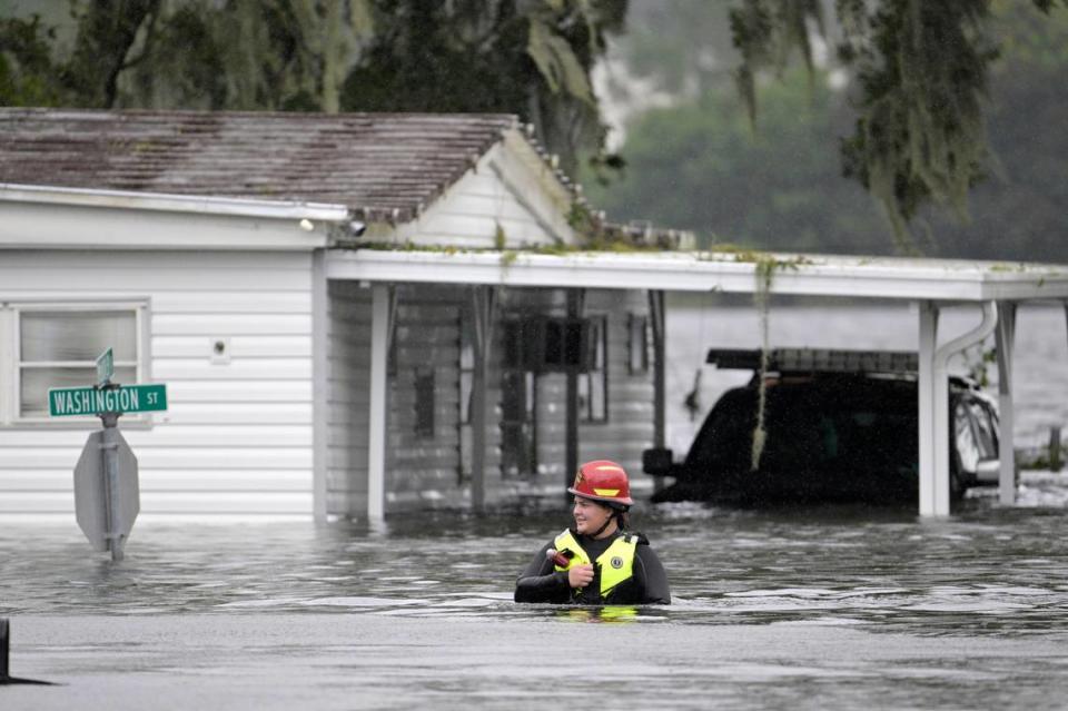
Trees falling onto power lines could lead to outages, but flooding remains the greatest concern, and people should stay off roads, Charlotte-Mecklenburg emergency management officials warned Thursday.
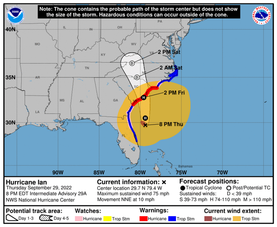
Ian weakened to a tropical storm Thursday, but by 5 p.m., it strengthened into a hurricane again and was “taking aim at the Carolinas and Georgia with life-threatening flooding, storm surge and strong winds,” according to a National Hurricane Center bulletin.
The center of the storm is predicted to move farther inland across the Carolinas on Friday night and Saturday, National Hurricane Center officials said.
NC activates National Guard
“Today is the time for all North Carolinians to ready themselves to stay safe,” Gov. Roy Cooper said at a news conference Thursday afternoon. “This storm could still be dangerous and even deadly.”
Cooper on Wednesday declared a state of emergency, in part to activate the state’s emergency operations plan and protect consumers from price gouging. The move also waives size and weight requirements for vehicles providing relief and temporarily suspends the weighing of vehicles carrying livestock, poultry or crops ready to be harvested.
On Thursday, Cooper said he also activated the North Carolina National Guard to assist with storm-related emergencies.
The N.C. Department of Transportation readied 374 backhoes and loaders, 223 motor graders, 1,436 chainsaws and 1,371 trucks to remove downed trees and other debris from roads.
“This storm could make travel treacherous in North Carolina,” N.C. Transportation Secretary J. Eric Boyette said in a news release Thursday.
Kimball, the NWS meteorologist, said the center of Ian could make landfall anywhere from Savannah, Georgia, to northeast of Charleston, given its wide projected-path cone.
The center of the storm is expected to reach Charlotte by roughly 2 a.m. or 3 a.m. Saturday, Kimball said.
The concern for Charlotte is Ian’s bands of heavy rain expected Friday afternoon and evening, he said.
Expect flooding, he said. “Four inches of rain is a lot in such a short period of time,” he said.
Ian is forecast to weaken to tropical depression status or less by its arrival in the Charlotte area, Kimball said, but the expected rain and wind gusts still pose concerns, such as flooding and power outages. Tropical depressions carry winds of less than 39 mph, according to the National Weather Service.
Where is Ian?
At 8 p.m. Thursday, Ian packed 75-mph winds about 215 miles south of Charleston and about 300 miles south-southwest of Cape Fear, North Carolina.
Thursday morning, the National Hurricane Center issued a hurricane warning for the entire coast of South Carolina.
A tropical storm warning or tropical storm watch also is in effect for a large part of the North Carolina coast, McClatchy News reported. A flood advisory for the North Carolina coast started at 2 p.m. Thursday, according to the National Weather Service.
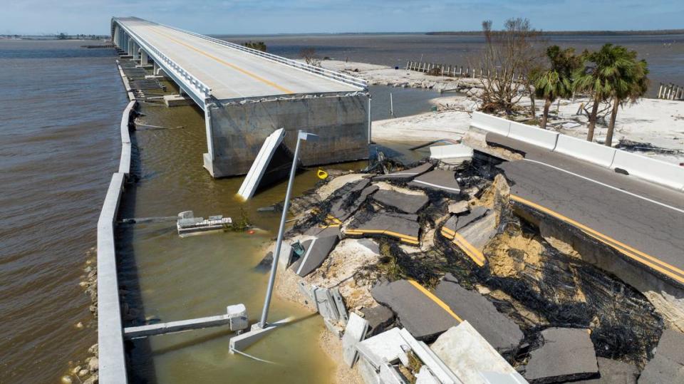
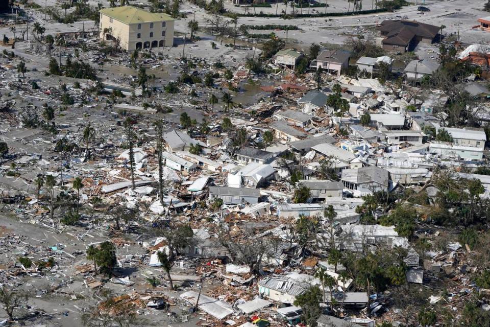
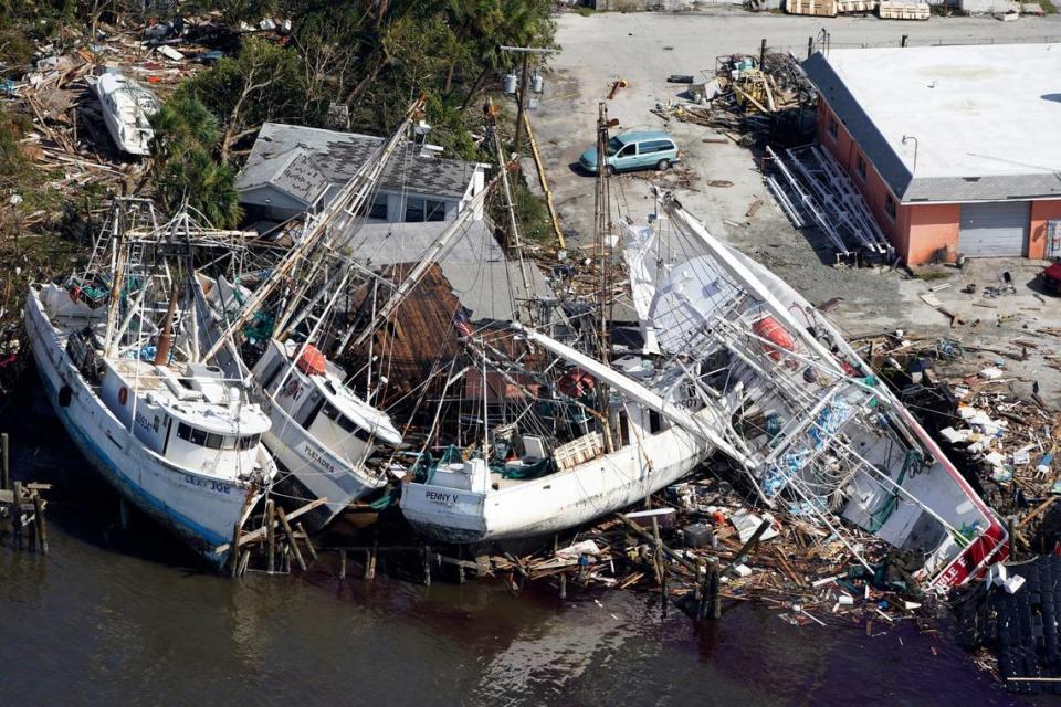
The storm has left more than 2.6 million people without power in southwest Florida, The Associated Press reported. A chunk of the Sanibel Causeway fell into the sea, cutting off access to the barrier island where 6,300 people normally live, according to AP.
Ian hit the southwest Florida coast early Wednesday as a Category 4 hurricane with 150 mph winds, tying it for the fifth-strongest hurricane ever to hit the U.S.
At least one person has died in Florida because of the storm, AP reported.
CLT airport delays, cancellations
At least 130 flights were canceled between Charlotte Douglas International Airport and airports in Florida, Georgia and South Carolina by 3:30 p.m. Thursday, according to FlightAware.com, a flight-tracking site. Nearly 60 flights between CLT and Florida destinations scheduled for Friday have been canceled.
American Airlines, Delta Air Lines and other carriers are letting passengers rebook without change fees if their flights are affected by Hurricane Ian.
American, which has a hub in Charlotte, issued a travel alert for 20 airports in the western Caribbean and Florida on Monday, allowing for the no-change-fee rebookings.
American is the dominant airline at Charlotte Douglas International Airport.
Southwest and United also issued travel waivers for many Florida-bound passengers.
Anyone headed to CLT airport should allow extra time for dropping off or picking up passengers. The airport closed its upper-level roadway for two weeks Tuesday night so crews could begin work on a new canopy.
Drivers should expect to see safety fencing and signs directing them to the lower level for arrivals and departures, the Observer previously reported.
Charlotte forecast
Charlotte has an 90% chance of showers beginning after 11 a.m. Friday, a 100% chance Friday night and early Saturday, a 60% chance Saturday morning and afternoon and a 40% chance Saturday night and early Sunday, according to the NWS forecast at 4 p.m. Thursday.
The chance of showers rises again to 50% the rest of Sunday and early Monday before falling to 30% the remainder of Monday, according to the forecast. Tuesday, Wednesday and Thursday should be all sunshine, according to the NWS Greer office.
Highs are predicted to fall from 71 on Thursday to 61 Friday, and then climb to 66 Saturday and Sunday, the forecast showed. Monday’s high is expected to drop to 62 before Tuesday’s could jump to 67, Wednesday’s 72 and Thursday’s 76, according to the NWS Greer office.
8 AM EDT Advisory: Deep tropical moisture associated with #Ian will bring the potential for flash flooding and possibly some main-stem river flooding. Gusty winds are forecasted to begin today. With strongest gusts Friday afternoon and evening. #scwx #ncwx #gawx #HurricaneIan pic.twitter.com/TW8NGFOuOZ
— NWS GSP (@NWSGSP) September 29, 2022
We continue to urge all Mecklenburg County residents to prepare. Have an emergency kit, a family communications plan, and ensure that you are able to receive emergency alerts. You can sign up to receive emergency alerts at https://t.co/YmlgH5SUXs. https://t.co/ANgeqjN1HO
— Charlotte-Mecklenburg Emergency Management (@CharMeckEM) September 29, 2022

