Hurricane Ian vs. Hurricane Charley: Ian potentially 'catastrophic' for Florida, forecasters say
The powerful hurricane swept over Cuba, strengthened into a monster in the Gulf and roared ashore Florida near Sanibel Island before tearing across the state and causing billions of dollars in damage, finally emerging above the east coast and curving back to hit South Carolina.
No, not Hurricane Ian. That was Hurricane Charley, in August of 2004, the strongest hurricane to hit Southwest Florida as far back as we have records. But Ian's path is looking eerily similar, and it may be more powerful.
Landfall forecast for Florida: Why cataclysmic Ian may eclipse Charley in hurricane history | WeatherTiger
Latest updates: Near-Category 5 Hurricane Ian nears Sarasota-Manatee with 155 mph winds
But there are some important differences between the two storms.
How strong was Hurricane Charley when it hit Florida?
Like Ian, Hurricane Charley crossed the western end of Cuba but avoided the mountains that often weaken storms and rapidly intensified from a Category 2 to a Category 4 with 150 mph winds before making landfall near the island of Cayo Costa, Florida. It weakened quickly, but it was still a Category 1 hurricane with gusts up to 105 mph by the time it passed over Orlando.
Charley caused ten deaths and an estimated $24.6 billion in damage (adjusted to 2022 dollars), according to Weather Underground.

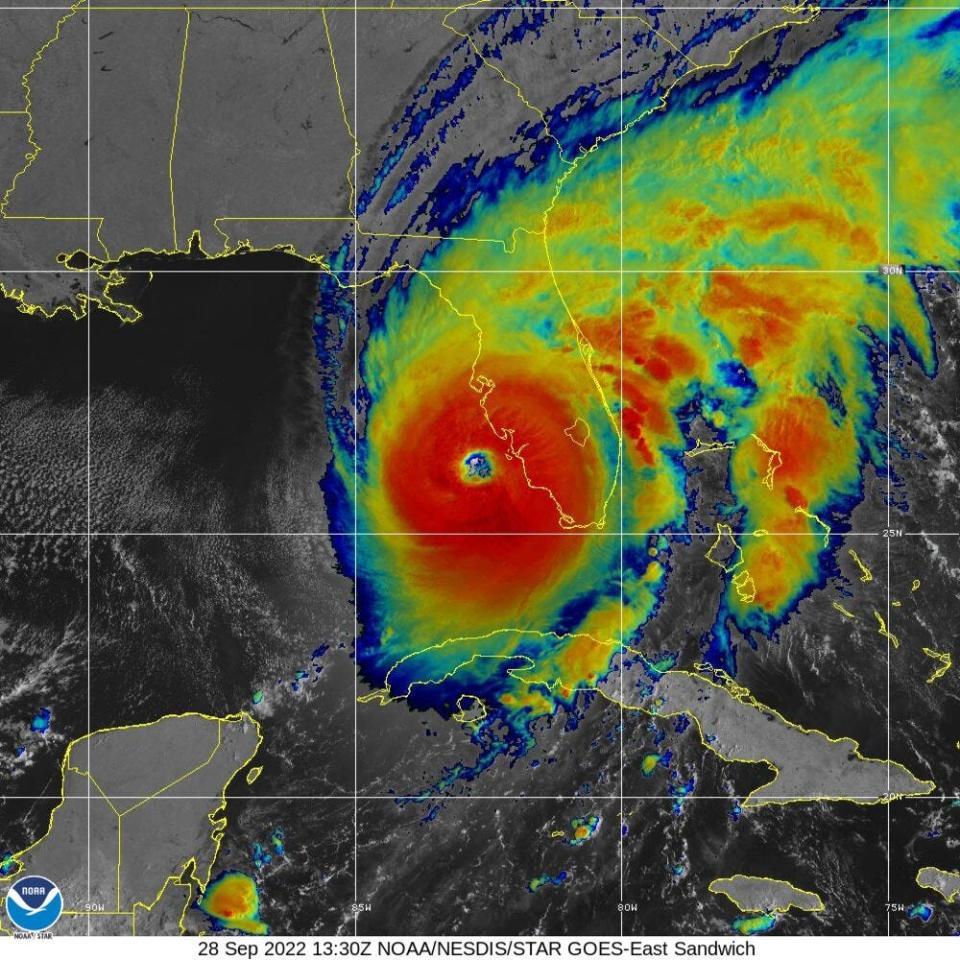
Ian also is currently projected to make landfall near Sanibel Island as an extremely dangerous Category 4 storm with 155 mph winds, but it's just on the edge of becoming a Category 5 and it may continue to strengthen. The local impact will be devastating.
"Extremely dangerous eyewall of Ian moving onshore," the NHC update reported. "Ian will cause catastrophic storm surge, winds, and flooding in the Florida peninsula soon."
@ryanhallyall our @RadarOmega @cyclonePORT Sanibel Island surge pack is taking a beating! pic.twitter.com/ssYRa1KEPU
— Drew Richards (@drew_richards) September 28, 2022
Ian approaches Florida: Hurricane Ian approaching Florida coast near Sanibel Island with 155-mph winds
Ian packing a punch: Gov. Ron DeSantis calls strengthening Hurricane Ian the 'real deal'
Interactive map: See the chances for projected wind speeds in your community
How fast was Hurricane Charley moving when it hit Florida?
Charley was moving north-northeast at around 21-25 mph and moved quickly across the state as it weakened, leaving Florida after just eight hours.
As of 11 a.m. Wednesday, just before landfall, Ian had slowed down to only 9 mph.
That means Ian will have more time to crawl across the state, more time for wind, rain and flooding, more time to generate tornadoes, and more time to cause devastation to infrastructure, power lines and homes.
#Ian is not #Charley...
Although the tracks of Cat4 Ian '22 and Cat4 Charley '04 are eerily similar, the sizes are VERY different. As of 5am Wednesday, Ian's area of hurricane-force winds is 2.9 times larger, and its area of tropical storm force winds is 2.3 times larger. pic.twitter.com/wCWPiJDzfh— Brian McNoldy (@BMcNoldy) September 28, 2022
How big was Hurricane Charley?
And here's the real difference: Charley wasn't that big. With all the damage it caused, it was fairly contained to a limited area in its swath across Florida. The worst storm surge was around seven feet in a small area of the state's west coast. Still terrible, but not as bad as it could have been.
Ian is a lot bigger. As of Wednesday morning, Ian's area of hurricane-force winds was nearly three times larger than Charley's, up to 45 miles from the center, and its area of tropical-storm-force winds extended outward up to 175 miles.
The National Hurricane Center has projected possible storm surges up to 12-18 feet in the Charlotte Harbor area, extending within 30-40 miles along the coast of Southwest Florida, and possible surges of 6-10 feet beyond that.
Also, NHC forecasters said Ian is likely to remain more intact as it crosses the Florida peninsula due to both its stronger initial wind speed and its faster forecast forward speed, which means a greater threat of tropical- and hurricane-force winds across the state to the east coast.
Hurricane Ian may remind us of Charley, but this bigger, stronger, slower storm has the potential to be truly cataclysmic.
C. A. Bridges is a Digital Producer for the USA TODAY Network, working with multiple newsrooms across Florida. Local journalists work hard to keep you informed about the things you care about, and you can support them by subscribing to your local news organization. Read more articles by Chris here and follow him on Twitter at @cabridges
This article originally appeared on Fort Myers News-Press: Hurricane Ian vs. Hurricane Charley: Three things to know

