'Catastrophic storm surge, winds and flooding': Hurricane Ian batters Florida after landfall
Hurricane Ian is causing "catastrophic storm surge, winds and flooding," according to the National Hurricane Center, after making landfall at 3:05 p.m.
Maximum sustained winds have weakened significantly since landfall, down to 90 mph at the 11 p.m. advisory, making it a Category 1 storm. It was a Category 4 with 150 mph maximum sustained winds at landfall.
The center of the storm was located about 52 miles southeast of Lakeland.
► Cone of uncertainty: See the latest graphic from the NHC
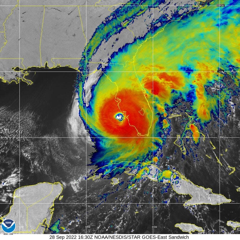
► Satellite images: See latest satellite image from NOAA, for a clearer picture of the storm's size
► Florida web cams: See conditions around Florida
► Live coverage: Hurricane Ian targets Florida
At 11 p.m., hurricane conditions continued across portions of Southwest Florida.
Hurricane Center forecasters said Ian is likely to remain more intact as it crosses the Florida peninsula — due to both its stronger initial wind speed and its faster forecast forward speed — and this now increases the threat of hurricane-force winds on the east coast of Florida.
Hurricane warnings and watches have been issued for several areas along Florida's East Coast.
Catastrophic storm surge inundation of 12 to 18 feet above ground level along with destructive waves are expected somewhere along the southwest Florida coastline from Englewood to Bonita Beach, including Charlotte Harbor.
Catastrophic wind damage is beginning along the southwestern coast of Florida today near the landfall location. Hurricane-force winds are expected to extend well inland along near the core of Ian.
Widespread, life-threatening catastrophic flooding is expected across portions of central Florida with considerable flooding in southern Florida and northern Florida.
Hurricane conditions are expected along the east-central Florida coast overnight, where a hurricane warning has been issued.
Hurricane conditions are possible from northeastern Florida to portions of South Carolina on Thursday and Friday, and a Hurricane Watch has been issued for that area.
More coverage on Hurricane Ian
► Hurricane Ian makes landfall in Cuba as it strengthens to Category 3
Live updates: Hurricane Ian on brink of Category 5 status as it nears Florida landfall
► Hurricane Ian nears Florida threatening storm surge. Graphics explain the deadly weather event
Ian is moving toward the north-northeast near 8 mph, and a turn toward the northeast and north is expected during the next couple of days.
On the forecast track, the center of Ian is expected to move across central Florida overnight and Thursday morning and emerge over the western Atlantic by late Thursday.
Ian is forecast to turn northward on Friday and approach the northeastern Florida, Georgia and South Carolina coasts.
Maximum sustained winds lessened to 90 mph, with higher gusts. Ian is a category 1 hurricane on the Saffir-Simpson Hurricane Wind Scale.
Further weakening is expected for the next day or so, but Ian could be near hurricane strength when it moves over the Florida East coast Thursday, and when it approaches the northeastern Florida, Georgia and South Carolina coasts on Friday.
Hurricane-force winds extend outward up to 45 miles from the center and tropical-storm-force winds extend outward up to 175 miles.
Where is Hurricane Ian now?
Here is the latest data on Hurricane Ian pulled from the National Hurricane Center's 11 p.m. advisory.
Location: 52 miles southeast of Lakeland
Maximum sustained winds: 90 mph
Movement: north-northeast at 8 mph
Pressure: 972 MB (millibars)
When next advisory will be released: 2 a.m. (although NHC is issuing hourly updates as conditions change)
Spaghetti models: Track Ian here
Helpful hurricane resources and links
Get your home ready: Here's how to prepare your home for a hurricane, from well in advance to just before a storm's arrival
Need to prepare for a hurricane? Here's what you should have in a disaster supply kit
Hurricane preparedness list: If a storm is coming, here is what you need to do now
Video: Helpful tips for a hurricane survival kit
Hurricanes, typhoons, and cyclones: What’s an invest and why do they keep saying tropical cyclone?
Officials encourage residents to assemble a hurricane kit early, storing enough supplies to last at least three days. Doing so ensures there are adequate supplies available on store shelves and prevents a rush — and shortages — that regularly occur when a storm is imminent.
Stay informed on what's happening in your area. Consider becoming a subscriber.
This article originally appeared on The Ledger: Hurricane Ian causing storm surge, flooding in Florida after landfall

