When will Hurricane Ian reach Florida?
More than 2 million people are under evacuation orders as Hurricane Ian barrels toward Florida, and officials are warning residents to leave before conditions worsen.
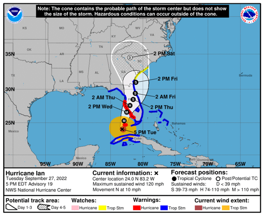
The storm’s center was located in the Gulf of Mexico about 200 miles southwest of Punta Gorda, Fla., and moving north at 10 miles per hour as of 7 p.m. on Tuesday evening, according to the National Hurricane Center (NHC).
Key West is already experiencing winds gusting up to 71 miles per hour, with conditions expected to deteriorate as the Category 3 storm strengthens and moves closer to the mainland.
The NHC forecasts Ian to make landfall on Florida’s Gulf Coast between Wednesday afternoon and early Thursday morning, but impacts are expected across the state.
“We know this thing is going to be hitting the state directly some time tomorrow evening. You still have some time, but that time is rapidly running out,” Florida Gov. Ron DeSantis (R) said at a Tuesday evening press conference, addressing the more than 2.5 million Floridians under evacuation orders.
The trajectory of the storm shifted south throughout the day, with officials now expecting Ian’s center to hit between Fort Myers and Sarasota before traveling northeast across the state.
“There’s a lot of potential for flooding and storm surge in that part of the state,” DeSantis said.
The NHC projects the peak storm surge could reach 12 feet in Charlotte Harbor, with lesser amounts expected along the rest of the state’s Gulf Coast and in the Florida Keys.
“Life-threatening storm surge is increasingly likely along the Florida west coast where a storm surge warning is in effect, with the highest risk from Naples to the Sarasota region,” NHC said in its latest advisory. “Residents in these areas should listen to advice given by local officials and follow any evacuation orders for your area.”
The new forecast provides a better outlook for Tampa, however, which was previously expected to see the worst of the storm and is located on the coast about 100 miles north of Fort Myers. Tampa is particularly vulnerable to storm surges.
Forecasters previously projected Tampa to see a peak storm surge of up to 10 feet, although the updated trajectory has lowered that forecast to a maximum of six feet.
After making landfall, the storm is expected to weaken as it moves northeast across Florida on Thursday.
The NHC’s latest forecast shows Ian’s center reaching Orlando as a tropical storm on Thursday afternoon before reaching Florida’s east coast early Friday morning near Palm Coast.
The storm will then move north in the Atlantic Ocean near the coast before making landfall again in Georgia on Friday afternoon.
The National Weather Service has issued storm surge watches and tropical storm watches that extend into South Carolina.
For the latest news, weather, sports, and streaming video, head to The Hill.

