Hurricane Ian forecast to strike west Florida earlier and harder as track moves south
This article tracking Hurricane Ian is available for free as a public service to all readers.
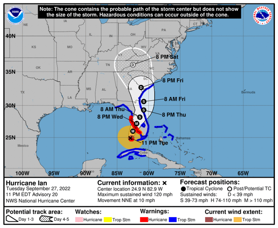
Hurricane Ian’s forecast track has once again shifted a little to the east, moving closer Cape Coral and away from heavily populated Tampa Bay. However, the storm is still expected to bring life-threatening storm surge and catastrophic winds to Florida’s west coast.
“Ian is forecast to approach the west coast of Florida as an extremely dangerous major hurricane,” the National Hurricane Center said.
While Ian may have slightly shifted late Tuesday night, it didn’t affect any of the current hurricane or tropical storm warnings, which most of the peninsula is under.
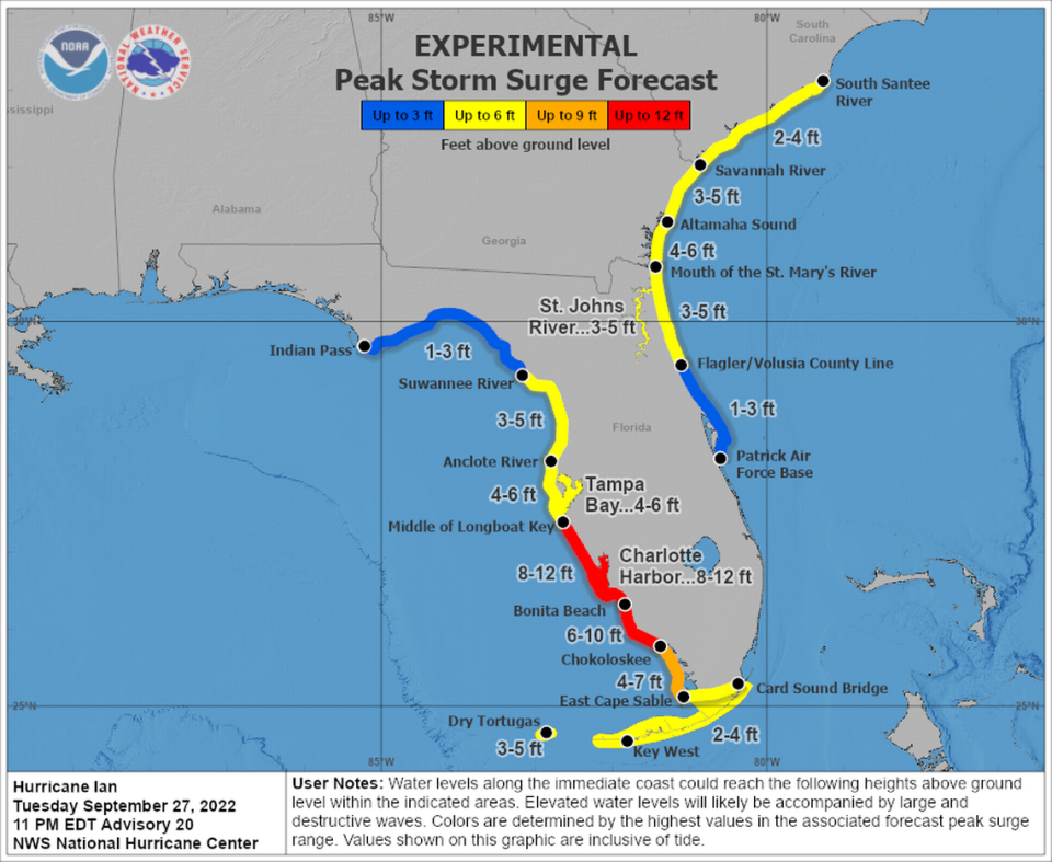
More than 2.5 million people had fled homes in high-risk coastal areas, some that could see storm surge of up to 12 feet. Flash-flood warnings were posted for South and Central Florida, where up to 24 inches of rain is also possible in the coming days. Tornado watches were also issued for much of southeast Florida.
Two tornadoes touched down in Broward, wreaking havoc. Numerous planes at North Perry Airport were flipped or torn apart, and neighborhoods saw downed trees and signposts.
READ MORE HERE: Two tornadoes tear through Broward, while Ian hounds Florida as a major hurricane
In the rest of the state: Schools were closed in many counties. Orlando theme parks are preparing to shut down. Massive power outages are likely.
In its 11 p.m. Tuesday forecast, the hurricane center put the Gulf Coast between Naples and Sarasota at the highest risk from Hurricane Ian.
Ian is forecast to come with Category 4 storm intensity, packing 130 mph winds and possibly bringing historic levels of storm surge to the Sarasota area.
Gov. Ron DeSantis urged Floridians in mandatory evacuation zones to heed officials and get out before it’s too late to leave.
“You don’t get a mulligan on this. It’s better to take the precaution and not have a significant impact than the reverse,” he said.
Floridians who haven’t left evacuation areas should do so immediately, DeSantis said Tuesday night. Hotels still have occupancy in Miami-Dade, Broward and Palm Beach counties and in the Panhandle, from Tallahassee to Pensacola.
Information on occupancy can be found at Expedia.com/Florida, he said, and shelters can be found in each county at https://www.floridadisaster.org/shelters.
“There will be catastrophic flooding and life-threatening storm surge on the Gulf Coast region,” DeSantis said. “This is a lot of nasty weather that we’re in store for over the next few days.”
‘Just get out’
One of the Floridians evacuating was Jeff Carey, a 59-year-old mold remediation specialist who left his Venice home in the Ridgewood Mobile Home Park Tuesday evening.
Carey has lived in this gulf shore community for more than a decade. He has seen the aftermath of hurricanes Ivan and Katrina, and he’s not taking any chances with Hurricane Ian. He knows that the water could rise high in his home.
“Just get out. Don’t stick around,” he said about an hour before evacuating to a friend’s sturdier building several miles inland. “If you’ve got any place to go, go. This is not a thing to mess around with. Very serious, and it’s like I said, it’s one of the biggest ones I’ve ever seen.”
Rain already sweeping South Florida
A day out from landfall, South Florida was already feeling Ian’s first gusty, rainy bands — particularly in the Keys, where king tides also worsened some street and neighborhood flooding.
Earlier Tuesday, predictions for Ian’s landfall were moved up by perhaps a half day to Wednesday afternoon, and there was a tropical storm warning to all of southeast Florida, including coastal Miami-Dade and Broward. South Florida was already seeing street flooding Tuesday morning, and officials urged residents of the Keys to take shelter as tornado warnings popped up.
READ MORE: When will South Florida, Keys see the worst of Ian and when will bad weather clear out?

Earlier landfall as a Cat 4
As of the 12 a.m. advisory from the NHC, Hurricane Ian was about 110 miles southwest of Naples.
It was still a Category 3 storm with 120 mph maximum sustained winds and a wind field holding at 140 miles from its center. It was heading north-northeast at 10 mph.
5am forecast on the left - New 11am forecast on the right. The landfall position again shifted slightly east & is now south of #Sarasota. With landfall less than 36 hours away now we focus on where worst wind damage & storm surge will be. #Sarasota to #FortMyers unfortunately pic.twitter.com/t4sCg0lNoC
— Bill Karins (@BillKarins) September 27, 2022
Ian’s center made landfall just southwest of La Coloma in the Pinar Del Rio Province of Cuba as a Cat 3 with maximum sustained winds of 125 mph at 4:30 a.m. Tuesday.
READ NEXT: Category 3 Ian batters western Cuba, leaves more than a million people without power
‘Worst case scenario’ averted
Earlier tracks beelined into Tampa Bay, which hasn’t seen a direct hit in a century. The bay is uniquely vulnerable to storm surge, a trend potentially worsened by rising sea levels.
The population bloomed in the last hundred years, setting nearly 3 million people up for devastation in what Jamie Rhome, the acting director of the National Hurricane Center, called a near “worst case scenario” for the area.
Florida Gulf Coast faces massive storm surge from Ian. Sea level rise could play a role
The city of Tampa ran out of sandbags by noon Tuesday after distributing nearly 50,000, and Tampa General, a waterfront hospital, had armored itself with an 8-foot storm surge barrier.
But on Tuesday, NHC forecasters nudged the track south, shifting the worst of the wind and storm surge impacts to the Sarasota area.
However, Rhome said, the drenching rains and still-high storm surge could lead to intense flooding.
“There’s been a narrative today that Tampa Bay has dodged a bullet. That is not true,” he said. “While the surge threat may have gone down a little as the track shifted… a band of very heavy rain looks like it’s going to set up to the north of where the center cuts through the state.”

DeSantis said Tuesday that officials are still prepared for that scenario, with food and water packages staged across the state and a helicopter ready to deliver it to the Pinellas County peninsula if the bridges go out.
“Hopefully, it doesn’t come to that,” he said.
What Florida will feel
Ian is now forecast to be a Cat 4 hurricane by the time it’s offshore of Florida’s west coast, with a potential landfall just northwest of Cape Coral Wednesday afternoon with 130 mph winds and gusts up to 160 mph.
“Interests along the Florida west coast in the Hurricane Warning area should be prepared for a large and destructive hurricane, and residents in this area should heed the advice of emergency management officials,” the hurricane center said.
At that point, the hurricane center expects Ian’s forward speed to slow to 5 mph, prolonging the heavy rains and storm surge and overall giving the storm much more time to soak Florida as it inches inland.
As Hurricane Ian floods streets, Miami-Dade County closing parks, libraries and courts
Because of that major slowdown, Florida is expected to see a lot of rain this week. South Florida and the Keys could see six to eight inches, while the Tampa Bay area could see more than a foot of rain, with up to two feet in some spots.
Rhome, acting director of the hurricane center, warned that Ian’s rains will arrive long before the winds will, which could lead to significant flooding risk hours before Hurricane Ian’s center nears the coast.
“A typical summertime thunderstorm here in Florida would put down 1 inch. Multiple that by 10 or 15,” he said.

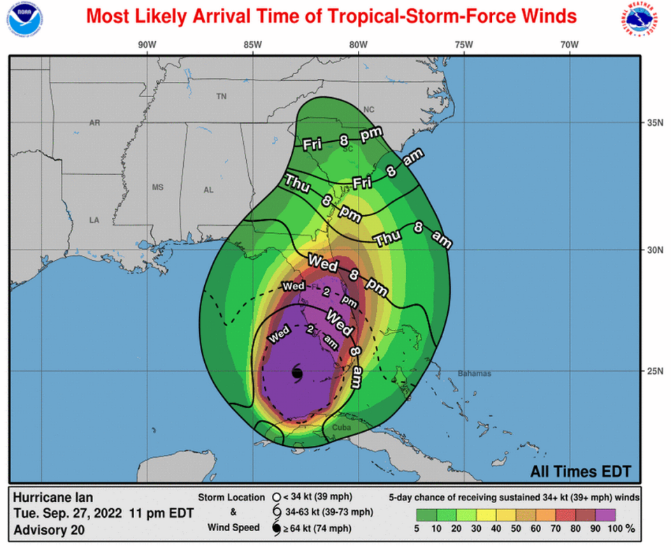
Key West was feeling tropical storm level winds Tuesday night, and hurricane-force winds will hit the Cape Coral to Tampa area beginning Wednesday morning. A storm surge warning was issued for the lower Florida Keys from Big Pine Key west to Key west.
They should be wrapped up by the end of the week, as Ian moves northeast across the state.
Nearly the entire state — except Southeast Florida and parts of the Panhandle — could see storm surge greater than two feet above dry land. The Sarasota area is the worst, with predictions for eight to 12 feet from the middle of Longboat Key to Bonita Beach.
Michael Lowry, meteorologist for WPLG channel 10, wrote in his Tuesday newsletter that the severity of the storm surge forecast “cannot be overstated.”
“Ian has the potential for delivering the type of life-threatening coastal flooding this stretch of Florida hasn’t seen in modern memory,” he wrote.
To put into perspective Ian's storm surge forecast from @NHC_Surge, here are monthly maximum water levels for two of our longest-running @NOAA tide gauges in the Tampa/St. Petersburg area. In over 50 years, we've not observed anything resembling the surge flooding predicted. pic.twitter.com/lFFdylg8YY
— Michael Lowry (@MichaelRLowry) September 27, 2022
For the east coast, this coincides with the annual highest tides of the year, king tides. It’s already accounted for in the NHC forecast, but the additional rainfall could lead to more intense flooding than usual for southeast Florida.
READ MORE: When will your Publix close before Ian? When will it reopen? What about Walmart, Target?
Miami Herald staff reporters Michelle Marchante, Devoun Cetoute and Joey Flechas contributed to this report.

