'Catastrophic winds': Hurricane Ian to approach Florida's west coast on Wednesday
Hurricane Ian remains a Category 3 hurricane with the same speed as earlier today, according to the 11 p.m. National Hurricane Center’s latest advisory.
Hurricane Ian made landfall in western Cuba early Tuesday as a powerful Category 3 storm.
Ian's maximum sustained winds are 120 mph and is expected to strengthen through Wednesday.
The center of Ian is expected to pass west of the Florida Keys within the next few hours. It is expected to move over central Florida Wednesday night and Thursday morning and emerge over the western Atlantic by late Thursday.
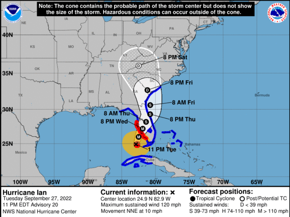
Cone of uncertainty: See the latest graphic from the NHC
And: See latest satellite image from NOAA, for a clearer picture of the storm's size
According to the NHC, hurricane conditions are expected along the west coast of Florida within the hurricane warning area on Wednesday morning, with tropical storm conditions possible Tuesday night. Ian is forecast to approach the west coast of Florida as an extremely dangerous major hurricane.
Heavy rainfall is expected to bring 6 to 8 inches of rain to the Florida Keys and South Florida, with isolated totals up to 12 inches.
For Central West Florida, 12 to 18 inches of rain, with isolated totals up to 24 inches. For Northeast Florida and the remainder of the Central Florida Peninsula, 5 to 10 inches of rain, with isolated totals up to 12 inches, is in the forecast.
'Widespread catastrophic' flash, urban and river flooding are expected midweek across central and west Florida. Widespread considerable flash, urban, and river flooding is expected across northern Florida, southeastern Georgia, and coastal South Carolina from the end of the week through the weekend. Limited river flooding is expected over portions of the southeastern United States into the Mid-Atlantic mid-to-late week.
Tornadoes are possible through Wednesday across central and south Florida.
A hurricane warning is in effect for:
Chokoloskee to Anclote River, including Tampa Bay
Dry Tortugas
A storm surge warning is in effect for:
Suwannee River southward to Flamingo
Tampa Bay
Dry Tortugas
Flagler/Volusia Line to the mouth of the St. Mary's River
St. Johns River
A tropical storm warning is in effect for:
Cuban provinces of La Habana, Mayabeque, and Matanzas
Suwannee River to the Anclote River
All of the Florida Keys
Flamingo to South Santee River
Flamingo to Chokoloskee
Lake Okeechobee
Florida Bay
Bimini and Grand Bahama Islands
A storm surge watch is in effect for:
Florida Keys from the Card Sound Bridge westward to Key West
Florida Bay
Mouth of St. Mary's River to South Santee River
#Ian continues to intensify and is now a major, Cat. 3, #hurricane with max sustained winds of 115 mph. Ian is the 2nd Atlantic major hurricane of the 2022 season (Fiona). It’s the 1st time since 1941 that Atlantic has had 2 major hurricane formations between September 20-27. pic.twitter.com/PZdPhu4lH1
— Philip Klotzbach (@philklotzbach) September 27, 2022
More coverage as Hurricane Ian approaches Florida
► Three scenarios, with divergent levels of destruction to Florida | WeatherTiger
► 'Floridians up and down Gulf Coast' warned as Hurricane Ian strengthens, could reach Category 4
► 'Impacts are going to be far and wide': DeSantis urges entire Gulf Coast to prepare for Ian
► Hurricane Ian's forecast calls for 'rapid intensification.' What does that mean?
Where is Hurricane Ian now?
Here is the latest data on Hurricane Ian pulled from the National Hurricane Center's 11 p.m. advisory.
Location: 110 miles southwest of Naples
Maximum sustained winds: 120 mph
Movement: north-northeast at 10 mph
Pressure: 952 MB (millibars)
When next advisory will be released: 2 a.m.
Spaghetti models: Track Hurricane Ian
Watches and warnings issued ahead of Hurricane Ian
If you can't see any local weather warnings here, you'll need to open this story in a web browser.
Helpful hurricane resources and links
Get your home ready: Here's how to prepare your home for a hurricane, from well in advance to just before a storm's arrival
Need to prepare for a hurricane? Here's what you should have in a disaster supply kit
Hurricane preparedness list: If a storm is coming, here is what you need to do now
Hurricanes, typhoons, and cyclones: What’s an invest and why do they keep saying tropical cyclone?
Officials encourage residents to assemble a hurricane kit early, storing enough supplies to last at least three days. Doing so ensures there are adequate supplies available on store shelves and prevents a rush — and shortages — that regularly occur when a storm is imminent.
USAT-Florida Network has removed the paywall for hurricane-related content for residents within the path of Ian to help keep everyone safe and informed during this emergency. Please consider subscribing.
This article originally appeared on Naples Daily News: Ian could become Category 4 storm off Naples, west coast of Florida

