Hurricane Ian: How will the Category 1 hurricane affect Delaware, and when?
Ian is no longer a hurricane but that doesn't mean it's not still causing havoc.
After battering Florida and South Carolina and leaving 31 people dead, including 27 in Florida, Ian proved to be one of the strongest systems in U.S. history, according to utility tracker poweroutage.us.
Ian strengthened into an "extremely dangerous" Category 4 storm Wednesday and roared to the brink of Category 5 status, its maximum sustained winds blasting at 155 mph as the west coast of Florida braced for landfall Wednesday afternoon. It's since moved north, didn't pack the same punch as it weakened considerably after causing damage across the south.
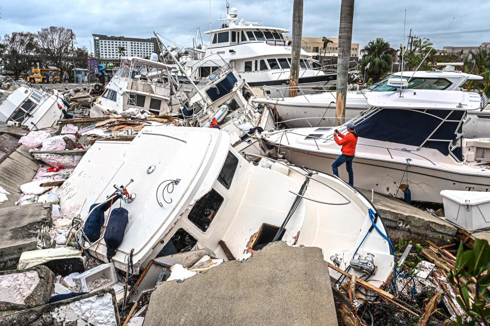
Florida Gov. Ron DeSantis described the storm as "500-year flooding event" and said Coast Guard helicopters were plucking trapped residents from the roofs of homes. Communities across the state were or will be swamped by the overwhelming waters, he said.
The storm previously tore into Cuba, killing two people and bringing down the entire country's electrical grid.
.@NOAA’s #GOESEast satellite captured this extraordinary imagery of #Hurricane #Ian making landfall near Cayo Costa, Florida this afternoon.
Latest: https://t.co/0wCH4mn6NI#FLwx https://t.co/FX10iDGu4H pic.twitter.com/01tbXjdgZh— NOAA Satellites (@NOAASatellites) September 28, 2022
Hurricane Ian projected path
Heavy rains and tropical storm conditions had already reached the coasts of Georgia and the Carolinas by Friday morning, where life-threatening storm surge and hurricane conditions were expected to develop. Rainfall of up to 8 inches threatened flooding from South Carolina to Virginia, the National Weather Service reported.
Meteorologists were expecting conditions to steadily deteriorate across Charleston on Friday morning, when Ian was located 105 miles south-southeast of the coastal city with 85 mph winds. Traffic had cleared the streets, muting the typically bustling morning commute ahead of the storm.
How storm surge works:Graphics explain the deadly weather event
Live updates:South Carolina braces for Hurricane Ian; 2M in Florida without power as deaths likely rise
Hurricane Ian tracker: Where is powerful storm headed next?
How will Hurricane Ian affect Delaware?
Ian brought lots of rain and winds to Delaware on Friday night and Saturday morning, but now the area remains dry with lots of clouds. But don't put away the umbrellas just yet.
According to the National Weather Service, rain will be back late Saturday night and should linger around for most of Sunday, and possibly into early Monday morning.
Flash flooding has a slight possibility, or 15 percent chance, of hitting southern Delaware and a marginal, or 5 percent, possibility of occurring throughout the rest of the state, according to a three-day outlook from the National Oceanic and Atmospheric Administration.
Extended weather forecasts for Rehoboth Beach call for increasing winds through Tuesday, with high probabilities of rain on Saturday and Sunday.
Additionally, minor coastal flooding will begin to ramp up with today's high tide (attached graphic). We've issued a Coastal Flood Advisory for Cape May and Sussex (DE) Counties for today, although more widespread minor coastal flooding is forecast over the weekend. #NJwx #DEwx pic.twitter.com/kNb8qoAbhp
— NWS Mount Holly (@NWS_MountHolly) September 30, 2022
The NWS advisory says minor coastal flooding is expected with the high tides Saturday and Sunday afternoons, and moderate coastal flooding is possible during Monday afternoon high tide.
Madison Sparrow's final days:How two people she once loved committed the ultimate betrayal
This article originally appeared on Delaware News Journal: Hurricane Ian tracker: Follow storm's path from Florida to Delaware

