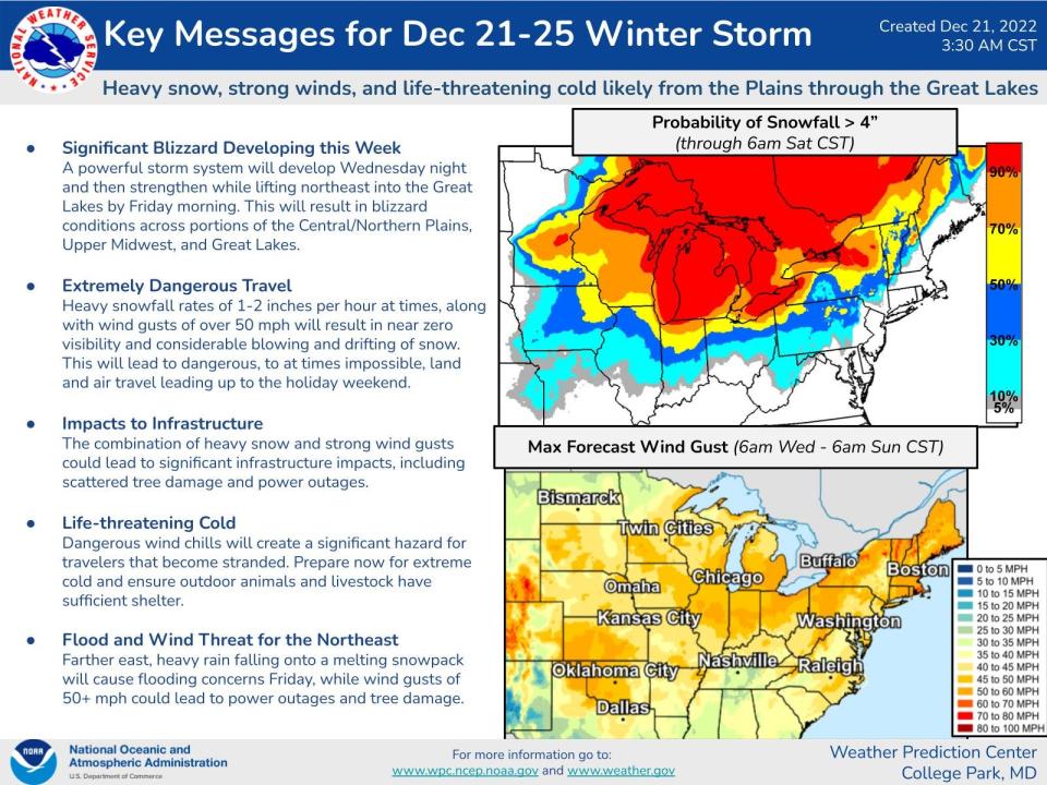
Here are the latest Winter Storm Elliott updates for Akron-Canton region
Temperatures remain slightly below zero Friday night as Winter Storm Elliot continues to keep Northeast Ohio in a blustery icebox. Forecasters predict a high approaching 10 on Saturday, with continued windy conditions.
With nightfall arriving and snowfall diminishing, Summit County downgraded its snow emergency from Level 2 to Level 1 at 6 p.m. Under Level 1, roadways are considered hazardous with blowing and drifting snow and can also be icy. Motorists are encouraged to drive very cautiously.
Power outages fluctuate through the day
After an afternoon where thousands were without power in freezing temperatures, outages were down to around 900 total as of 8 p.m. in Summit and Portage counties, although frigid temperatures continued.
In Summit County, outages were around 600 customers, down from nearly 5,000. Portage County outages were just under 300, when there had been around 3,200 without power.
However, power outages across the region have fluctuated all day.
Over 26,000 customers had been without power at 4:30 p.m. − down from nearly 40,000 just two hours earlier. By 6 p.m., the total number was down to around 16,000, but had increased to 25,000 by 8 p.m.
FirstEnergy reported the bulk of the outages continue to be in the northern section of the state. AEP reported 21,240 customers without power in Ohio including around 1,100 in Stark County and 1,500 Wayne County.
High winds forecast to continue into evening
Snow has largely moved out of Northeast Ohio, but gusty winds continue to blow snow across roads as a frigid cold settles in for the Christmas weekend.
The National Weather Service reported a 74 mph wind gust at Fairport Harbor on Friday morning on Lake Erie, which is nearly hurricane strength. The temperature dropped 45 degrees between 2 a.m. and 10 a.m. at the Akron-Canton Airport. It was -5 degrees as of 2 p.m. At 8 p.m., temperatures were -1 at the Cleveland Hopkins International Airport, and -3 at the Akron-Canton Airport.
The next phase of the storm in the form of high winds will now be the greatest risk as wind gusts up to 60 miles per hour, the National Weather Service said.
The winds continue to howl in northern Ohio. As of noon Friday, the peak wind gust at the Akron-Canton Airport was 43 miles per hour with "heavy blowing" snow. Hopkins airport in Cleveland has had a peak wind gust of 48 mph while the Wayne County Airport in Wooster recorded a peak gust of 51 mph. Lahm Regional Airport in Mansfield has had a peak gust of 43 mph. The National Weather says Fairport Harbor has had a wind gust of 74 mph which is the equivalent of a Category 1 hurricane strength wind speed.
Wind chills were anywhere from 25 to 35 degrees below zero today. The weather service was "discouraging any travel unless absolutely necessary" this morning and afternoon.
"At 10 a.m., wind chill values were downright dangerous," the NWS said. "Several points across were reporting below -30F. If you venture out today, please keep your exposure time down and dress in layers."
"Roads are becoming icy and snowy," the NWS said before dawn this morning.
Warnings continue into Saturday morning
Summit County Sheriff Sheriff Kandy Fatheree issued a Level 2 Snow Emergency for Summit County around 8:30 a.m., which was downgraded to a Level 1 at 6 p.m. Friday. By 9 a.m., the Portage County Sheriff's Office announced the county was also under a Level 2 Snow Emergency until 10 a.m. Medina County has also declared a Level 1 Snow Emergency. Stark County did not declared a snow emergency.
Amazon has temporarily stopped deliveries in the region just two days before Christmas.
"We’ve been tracking storms in various regions throughout the U.S., and out of an abundance of caution, we’ve temporarily closed some of our sites in the impacted areas," said Barbara Agrait, an Amazon spokesperson. "We’ll continue monitoring weather patterns and will reopen sites and resume operations when it’s safe to do so.”
The NWS has issued a winter storm warning and wind chill warning through 10 a.m. Saturday. It also issued a blizzard warning for the first time in 10 years, although that warning only covers counties bordering Lake Erie from Cleveland to Pennsylvania.
In Stark County, SARTA is operating bad weather routes until the side roads are passable. The limited routes can be found online.
The Ohio Highway Patrol said a crash involving 50 vehicles reportedly caused one death and multiple injuries Friday afternoon on the Ohio Turnpike in Sandusky County, according to the Port Clinton News Herald.
The News Herald reported that both directions of the turnpike were closed between Ohio 53 and Ohio 4 as Sandusky and Ottawa counties remain under a Level 3 snow emergency.
Here are the latest updates for the Akron-Canton region.
3 water main breaks in Akron
There were three water main breaks in the city of Akron on Friday morning. Crews were out working on all three as of 11 a.m., said Chris Ludle, the city's director of public service.
The breaks, which were all in 6-inch water mains, were at the intersection of Huntington Avenue and Nash Street, just north of East Exchange Street and just east of state Route 8 in University Park; the intersection of Sunset View Drive and Delia Avenue in West Akron; and between the 1200 and 1300 block of Sparhawk Avenue in Goodyear Heights.
There are no boil advisories in place. People in the area may temporarily be out without water at points during the repairs, but Ludle said he doesn't expect it to be for long.
How much snow are we getting?
Total snow accumulations are forecast as 4 to 6 inches, with winds gusting as high as 65 mph and dangerously cold wind chills expected, as low as 30 below zero. At 4 a.m., the National Weather Service was expecting another 3 to 5 inches.
When will the snow end?
Snow is ending for now across Northeast Ohio.
"Snow tapers into the afternoon but dropping temperatures continue as winds increase, leading to dangerous wind chills and increased blowing snow today and tonight," the National Weather Service in Cleveland tweeted at 5:11 a.m. Friday.
What warnings and emergencies are in effect?
Around 8:30 a.m., Sheriff Kandy Fatheree issued a Level 2 Snow Emergency for Summit County. That warning was downgraded to Level 1 at 6 p.m. The Portage County Sheriff's Office at 9 a.m. announced the county is under a Level 2 Snow Emergency until 10 a.m.
Snow emergency levels:What are snow emergency levels in Summit County, Ohio and what do they mean?
The National Weather Service has issued a blizzard warning — a first in some 10 years — for the lakeshore counties. The weather service says the bulk of the heaviest snow is moving out of the state but snow is still falling throughout the region.
How long will the winter storm warning and wind chill warning last?
A winter storm warning ends at 10 a.m. Saturday.
A wind chill warning ends at 10 a.m. Saturday.
For the wind chill warning, dangerously cold wind chills are occurring getting as low as 30 below zero.
For the winter storm warning, heaving snow is occurring. Additional snow accumulations of 1-2 inches with wind gusting as high as 60 mph.
What is wind chill?: Northern Ohio weather factors that determine what's a dangerous wind chill
Temperatures are expected to remain in the single digits through Sunday. This combined with the strong winds would allow for a long period of wind chills well below zero. The cold wind chills could cause frostbite on exposed skin in as little as 30 minutes.
The National Weather Service says the "multi-hazard winter storm" will bring a combination of strong winds, very cold temperatures, snow, and blowing snow with total snow accumulations of 4 to 6 inches. Winds will gust as high as 65 mph. Dangerously cold wind chills as low as 30 below zero are possible. Temperatures this low for an extended period will impact infrastructure across the region with frozen pipes a concern.
National Weather Service map of observers on the ground throughout Portage and Summit Counties were measuring temperatures of around -5 as of 2 p.m. Reports of -6 in Twinsburg, Richfield and Coventry Township, a report of -7 in Copley and -6 in Rootstown Township. By 8 p.m., temperatures had risen to just below zero.
Current Akron-Canton road conditions
The National Weather Service says to plan on slippery road conditions. Widespread blowing snow could also significantly reduce visibility. The hazardous conditions could impact evening commutes and strong winds could cause tree damage.
The Brewster Fire Department reported Route 93 between 241 and Sarbaugh Street reopened after multiple utility poles fell across the roadway.
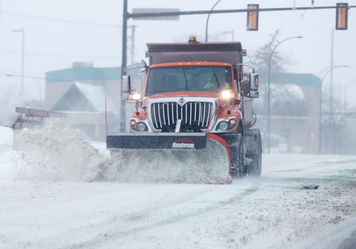
STARK COUNTY: We currently have 20 crews plowing and treating local roadways including this plow truck on U.S. 62 in Massillon. To see up to the minute road conditions, please check https://t.co/G3YX2DkkXN before you head out. #ODOTwinter pic.twitter.com/J6itEleZie
— ODOT Akron (@ODOT_Akron) December 23, 2022
The city of Akron said at 7:30 a.m. Friday that all streets are snow-covered. It said its pre-treatment was effective at providing decent traction, but there are still some pockets of slick conditions, and the drifting snow is impacting visibility. By 1:30 p.m. ODOT said 20 crews were plowing and treating the roads in Summit County.
"Snow is going to slow down through the morning but there is a lot of drifting snow due to the high winds so if you don't have to leave the house, it's best to stay in," the city said. "If you do have to travel, please go slow, give yourself plenty of time, and drive cautiously. We'd also like to give a special shoutout to the men and women who have been working through the night to keep our roads safe and drivable."
The city started its pre-treatment efforts Wednesday night by pre-treating third priority streets, then second priority streets, then first priority streets.
SUMMIT COUNTY: District 4 crews are currently plowing and treating roadways. This view is from one of our plows on I-77 in Fairlawn. If you have to travel today, please give yourself plenty of time. #ODOTwinter pic.twitter.com/n4ajRXsSoQ
— ODOT Akron (@ODOT_Akron) December 23, 2022
"We would normally pre-treat with salt brine but the rain would greatly reduce the effect of the brine," the city said. "Instead, we are using rock salt which has a much better chance of staying in solution when mixed with the rain."
The city said it would continue its storm response until the precipitation leaves the area and its full response efforts are complete. For service requests, visit akronohio.gov/311.
The Akron Metro Regional Transit Authority said it's experiencing some delays Friday morning, but buses are still running. Visit yourbus.org to track buses in real time or call 330-762-0341 for routes and times.
ODOT updates:View the latest ODOT-Akron information
The transit agency will also be operating on Christmas Eve and Christmas Day, operating its normal Saturday and Sunday schedules for fixed routes. ADA services will also be available, but demand response will not be offering services. The customer care information line (330-762-0341) will also be available both days, from 9 a.m. to 5 p.m.
SARTA will continue to will continue to provide transportation to the Salvation Army of Massillon today and Christmas Eve on routes 102 and 125. They're providing shelter from 8 a.m. to 5 p.m. both days due to the Winter Storm.
The Ohio Department of Transportation has about 1,200 plows out on the roads statewide. The state transportation agency is responsible for maintaining interstates and U.S. and state routes outside municipalities. ODOT's District 4 — which includes Summit, Stark, Portage, Trumbull, Mahoning and Ashtabula counties — has about 120 crews out.
Remember, ODOT isn't responsible for maintaining all roads in Ohio. #ODOTwinter pic.twitter.com/P6WWvpy1MV
— Ohio Dept of Transportation (@ODOT_Statewide) December 23, 2022
At 5:30 a.m. Friday, ODOT spokesperson Matt Bruning said on Twitter that conditions were hazardous across the state, despite having nearly 1,200 crews out. Road temperatures were in the teens in western Ohio and low to mid-20s in eastern Ohio. He said salt is less effective below 20 degrees, so ODOT was adding other materials in with the salt or brine.
As of 5:30 a.m. Friday, ODOT plows had covered 133,150 miles in 24 hours, with 34,276 in the previous two hours.
"Please avoid all unnecessary travel. Give our crews room and time to work," Bruning said. "Traveling? GO SLOW and allow a ton of extra time. Check OHGO.com for updates."
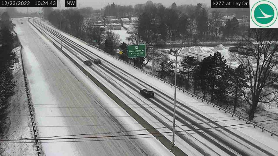
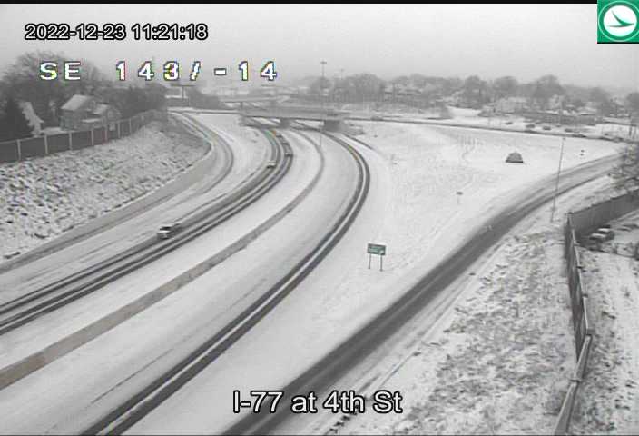
Check traffic cameras below for latest conditions.
Traffic camera:View camera at Akron Central Interchange (I-77-76)
Traffic camera: View I-77 near Akron-Canton Airport
Winter driving tips:Driving in northern Ohio this winter? These tips will help you get there safely
Akron-Canton weather forecast and timeline
This is the current forecast:
Friday: Snow, mainly before noon. Widespread blowing snow, mainly between 8 a.m. and 3 p.m. Temperature falling to around -4 by 11 a.m. Wind chill values as low as -30. Windy, with a west wind 24 to 28 mph, with gusts as high as 48 mph. Chance of precipitation is 100%. New snow accumulation of 1 to 3 inches possible.
Friday Night: A slight chance of snow showers before 11 p.m., then a chance of snow showers after midnight. Widespread blowing snow, mainly after 3 a.m. Cloudy, with a low around -4. Wind chill values as low as -30. Windy, with a southwest wind 24 to 26 mph, with gusts as high as 48 mph. Chance of precipitation is 30%. New snow accumulation of less than a half inch possible.
Be mindful heating your home:What to know about carbon monoxide poisoning, detection
Saturday: A chance of snow showers, mainly before 7 a.m. Areas of blowing snow. Cloudy and cold, with a high near 8. Wind chill values as low as -28. Breezy, with a southwest wind 22 to 24 mph, with gusts as high as 44 mph. Chance of precipitation is 30%. New snow accumulation of less than a half inch possible.
Saturday Night: A chance of snow showers, mainly before 1 a.m. Mostly cloudy, with a low around 6. Breezy, with a west wind 18 to 21 mph, with gusts as high as 37 mph. Chance of precipitation is 30%. Little or no snow accumulation expected.
Christmas Day: A slight chance of snow showers before 1pm. Mostly cloudy, with a high near 16. Chance of precipitation is 20%.
Sunday Night: Mostly cloudy, with a low around 6.
Monday: A chance of snow showers after 1 p.m. Mostly cloudy, with a high near 20. Chance of precipitation is 30%.
Power outages in Akron and Canton
The number of power outages fluctuated as winds gusted beyond 70 miles per hour in parts of northern Ohio. FirstEnergy says as of 2:30 p.m. there were some 39,556 customers in the dark in Ohio. The bulk of the outages were in the northern section of the state. FirstEnergy reported more than 2,000 customers were without power in Kent, 2,000 in Akron and 1,000 in Sagamore Hills. Outages in Portage County were around 3,200. Just over 4,900 customers were without power in Summit County. AEP reports 17,800 customers without power in Ohio including around 200 in Stark County and 1,400 Wayne County.
First Energy:Map of power outages in Akron area
AEP:Canton-area power outages map
In a Thursday press release, FirstEnergy said high winds of 40 to 50 mph will impact any power restoration efforts.
"Line crews cannot safely go up in bucket trucks to make repairs when wind speeds are excessive. In addition, plummeting temperatures will flash freeze standing water, creating icy road conditions that can make it difficult to access damage to make repairs. Crews will need to take frequent breaks to warm up in their trucks with wind chills dipping as low as minus 30 degrees Fahrenheit," the release said,
Ohio Edison Power outages can be reported online or by calling 888-544-4877.
Where to find warming centers in Akron and Canton
On Friday, Barberton opened a warming center at 500 W Hopocan Ave., the Active Adult Center, citing the number of power outages in the city, but closed at 2 p.m.
The Summit Lake Community Center in Akron at 380 W. Crosier St., will be open from 8 a.m. to 7 p.m. Friday, Dec. 23 through Monday, Dec. 26. All other community centers will be closed for the holiday weekend. More information here.
For Portage County, a warming center will open Thursday at The Haven of Portage County and will remain open until Wednesday.
In Canton, Refuge of Hope and the Edward "Peel" Coleman Community Center will be open for those in need from 6 p.m. Thursday to 8 a.m. Monday, during specific times.
According to a press release, the times were:
Coleman Center − 1400 Sherrick Road NE. Will be open 6 p.m. Thursday through 8 a.m. Friday; 6 p.m. Friday through 8 a.m. Saturday; and 4 p.m. Saturday through 8 am. Monday. Cots and blankets will be available.
Refuge of Hope − 715 Second St. NE. Will be open 8:30 a.m. to 5:30 p.m. Friday; and 4 p.m. Saturday through 8 a.m. Monday. No overnight stay. Hot beverages and food will be available.
SARTA will offer transportation, and the American Red Cross will provide cots and blankets. COVID-19 precautions, including masks, will be enforced, a press release said.
In western Stark County, Massillon Salvation Army, at 315 Sixth St. NE, will welcome those in need from 8 a.m. to 5 p.m., now through Saturday, city officials said in an email.
Additionally, Central Presbyterian Church, at 47 Second St. NE in Massillon, will provide blankets, coats, socks and hand warmers Thursday. SARTA buses also will provide warmth.
And, in Tuscarawas County, Mineral City Volunteer Fire Department, Tri-County Joint Ambulance District in Newcomerstown and Friends of the Homeless in New Philadelphia will offer 24-hour warming centers Friday through Sunday. If you plan to stay overnight, make sure to bring any medications you might need.
More information on warming centers in Canton linked here.
Weather-related closings and cancellations
Lock 3 in downtown Akron.
All Akron-Summit County Public Library locations closed Friday.
All Stark County Public Library locations closed Friday.
Portage County government facilities are closed Friday.
Canal Fulton library.
The Akron Zoo will be closed Friday, including the evening Wild Lights program. Will reopen Monday.
The Hudson Library and Historical Society is closed Friday.
Stark County Government government facilities including the county office building, Stark County Courthouse; and the BOW Building will be closed on Friday.
Massillon Museum is closed on Friday.
Boston Mills delays Friday opening to Saturday.
Portage County Public Libraries closed until Tuesday.
This is not intended to be a complete list. Please check with your destination.
Is there a parking ban near me?
The following areas have announced parking bans during the storm.
Green: Until noon Sunday.
Jackson Township: Friday to 10 a.m. Saturday.
Northfield Center Township from Friday to Monday.
Stow: Until noon Sunday.
Cuyahoga Falls: Until noon Sunday.t
Tallmadge: Until further notice.
Ski slopes update
The storm is a good news, bad news thing for Summit County's two ski resorts.
The good news is it cold enough to make snow and Mother Nature helped by dropping a quick 2 to 3 inches Friday morning but the extreme cold temperatures and high winds pushed back the first day of operations for the season at Boston Mills in Peninsula to Saturday.
Vail Resorts is encouraging visitors to ensure they dress appropriately and be prepared for cold temperatures and snow as they plan to crank up the snow-making machines at the resort. Vail's sister slopes, Brandywine is slated to open next week. Vail Resort's Alpine Valley in Geauga County also has not yet opened for the season.
Akron-Canton and Cleveland Hopkins airport status
The majority of flights arriving and departing from the Akron-Canton Airport and Cleveland Hopkins are canceled Friday. According to the website Flightaware.com, more than 5,600 flights have been canceled across the U.S. today and another 9,763 have been delayed. At Hopkins, about 150 flights will not take flight. The CAK website shows some flights are still scheduled to leave the airport today, but passengers are urged to check with the airport or their airline before heading out to the airport.
CAK:Current arrival and departure information
CLE:Current arrival and departure information
Ohio Turnpike bans high-profile vehicles
From 6 a.m. Friday through at least 8 a.m. Sunday, all high-profile tow-behind trailers, campers, boats and enclosed trailers are banned from the Ohio Turnpike due to high wind forecasts.
This article originally appeared on Akron Beacon Journal: Akron-Canton winter storm updates: Road conditions poor

