‘Everybody’s not counted’: Northern Beaufort Co. worries about effect on political districts
Residents are concerned that Beaufort County’s proposed political districts, drawn based on the 2020 Census — a shortened counting process because of the pandemic — will shortchange Black communities north of the Broad River.
On Monday night, residents came to the first of Beaufort County Council’s three public hearings on the new maps. Representatives from Beaufort, Lady’s Island, Port Royal, Burton and St. Helena were there to hear constituents’ concerns and questions.
Several residents said the maps will be biased against Black districts because of shoddy data from the census, which was conducted during the COVID-19 pandemic and faced several legal challenges.
“I know in my District, District 1, a lot of folks didn’t even know about the census,” said Earl Campbell, who has represented District 1 on the school board for more than 30 years.
“Before, they used to come around. Now you have to do it online. A lot of folks in District 1, District 3, St. Helena, those folks can’t do it this way. Everybody’s not counted, and this is not the first time this has happened.”
Research from the Urban Institute indicates that in the 2020 census, South Carolina was undercounted by 47,108 people, or about 1% of the state’s total population.
Black and Hispanic residents were disproportionately undercounted, with census-takers missing about 2.64% of the South Carolina’s Black population and 2.07% of the state’s Hispanic population; children 4 and younger were also undercounted by about 6% across the state.
“The federal government, because of the pandemic, shortened the process so there was probably a lot of people that were not counted,” said County Council Chair Joe Passiment.
Dawn Paige, president of the Lowcountry Equitable Land & Resource Trust, said that the undercount of the Black population will worsen disenfranchisement in District 3, which has the second-highest Black population of any district in the county behind District 1.
In addition to St. Helena and parts of Beaufort, District 3 includes Parris Island, where many military families complete the census but don’t vote in local elections or attend Beaufort County School District campuses.
“We already have a situation where resources aren’t being spent where they should in St. Helena and in District 3,” Paige said at Monday’s meeting. “I’m just wondering what kind of adjustments are going to be made, particularly when we’re looking at local spending.”
When Paige asked Passiment to commit to gathering “supplemental data” on county demographics, he demurred.
“The census data is the census data,” he said. “Whether or not there was undercounting, that’s something that these people who worked on the maps can’t change.”
What’s in the new maps?
The county has proposed two maps using the 2020 data. Both are candidates for consideration. One must be approved by Beaufort County Council in a series of three readings that would wrap up on Jan. 24.
The council’s executive committee will look at the maps Dec. 6, and the first and second readings for the final map are slated to take place Dec. 13 and Jan. 10.
Once a map is approved by county council, it goes to the state for final approval, and then the board of elections adopts the new districts, Passiment said.

Before that, county council planned two more public hearings on the maps. One was for 6:30 p.m. Tuesday at the Bluffton Rec Center for Districts 5, 6, 7 and 9. Another is scheduled for 6:30 p.m. Wednesday at the Hilton Head Island Recreation Center for Districts 8, 10 and 11.
Each map is designed to evenly distribute Beaufort County’s population into 11 districts, shrinking districts south of the Broad River that have seen enormous growth in the past decade and expanding districts North of the Broad where growth has slowed or shrunk. Each district should have a population of around 17,000.
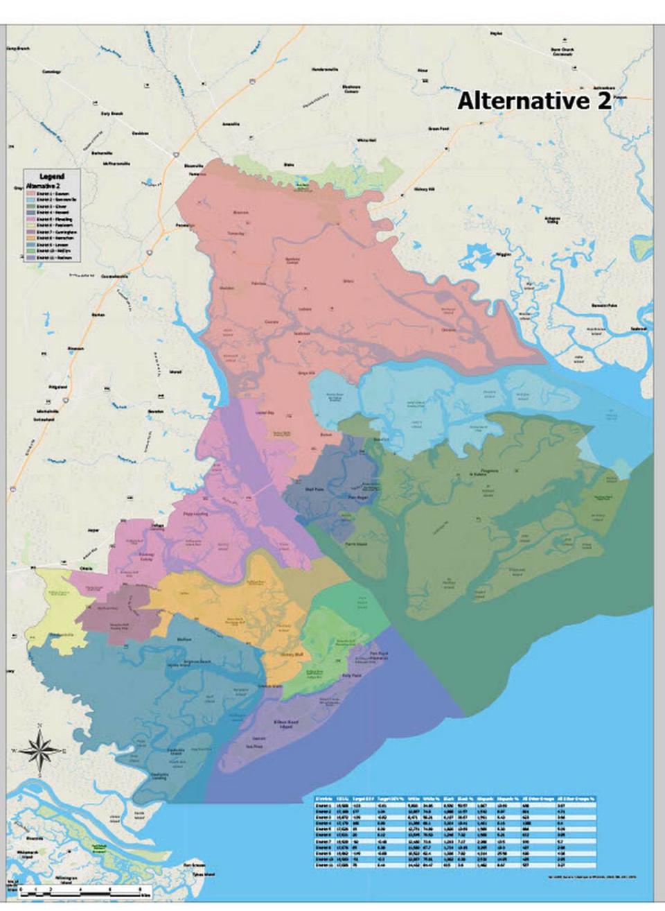
According to Passiment, the second proposed map is more even; each district’s population is within about 350 of the others.
In Bluffton, the Sun City district became more compact, according to Dan Morgan, Beaufort County’s director of mapping and applications. That resulted in New Riverside, Pritchardville and Heritage being moved outside the jurisdiction of all current county council members, which creates a vacancy with no incumbent.
North of the Broad, council member Paul Sommerville, who lives in Beaufort and represents District 2, would represent a corner of Harbor Island in the second map proposal. In map proposal #1, York Glover, who lives on St. Helena Island in District 3, would represent that slice of Harbor Island.
District 5 Council member Brian Flewelling, who lives in Beaufort, would be moved out of his district under the proposed maps and would have to decide whether to run against another member to stay on council.
The district boundaries proposed could change the districts of as many as four Beaufort County Board of Education members, forcing them to run against another member to stay on the board and leaving as many as two districts with no incumbent:
David Striebinger, who has represented Lady’s Island and parts of Beaufort in District 2 since 2016, would be moved to District 3 under the proposed Alternative 1 map. That district has been represented by William Smith since 2019.
Cathy Robine, who has represented parts of Bluffton and Hilton Head Island in District 8 since 2019, would be moved to District 10 in both proposed maps. Mel Campbell, the board’s vice chairperson, has represented that district since 2019.
Richard Geier, who has represented Burton in District 5 since 2019, would be moved to District 4 under map #1 and to District 1 under map #2. Those districts are represented by Tricia Fidrych and Earl Campbell, respectively.
Angela Middleton, who has represented Okatie in District 6 since January, would be moved to District 5 in both proposed maps.
Under both proposed maps, Districts 6 and 8 would not have incumbents; District 2 wouldn’t have an incumbent under map #1.
Both Campbell and Smith came to Monday’s meeting and said they were disappointed with the lack of communication between county council and school board about the new maps.
“As a school board member, an elected official, I’m disappointed,” Smith said. “It hurts the community. It’s very impactful for us to continue to rush this process.”

