Early fireworks in tropics, but three-pack of storms no danger zone for Florida | WeatherTiger
The recent runaway success of Top Gun 2: A Previously Unknown, Yet Higher Gun demonstrates that a common belief in Pete “Maverick” Mitchell is one of the few remaining sinews binding all Americans together, along with a love of sandwiches and the absolute certainty that those who disagree with us are wrong.
In honor of the year’s loudest and fastest three-day weekend ahead, the Tropics are respecting this shared conviction for living on the edge, with three disturbances pushing the boundaries of hurricane climatology for late June.
Tropics watch: Potential Tropical Cyclone Two moving fast. Invest 95L taking aim at Texas
Fortunately, all requests for a flyby of the U.S. coastline from organized storms have, as yet, been denied. The pattern is full.
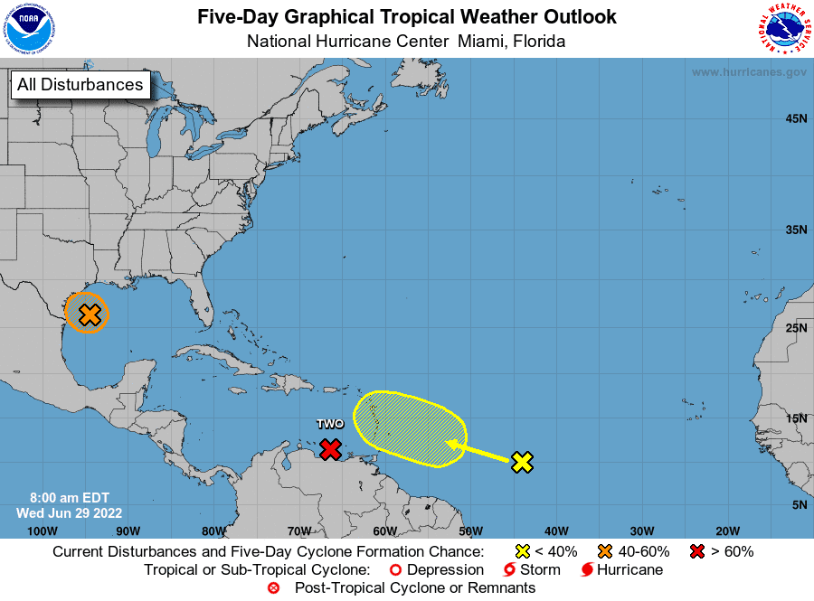
A wave with a chance of threatening Florida
Let’s tackle these three systems in reverse order of development odds, as the system with the best chance of becoming a tropical storm in the next few days is no threat to Florida.
Of the three, the only outside shot of impacting Florida’s weather down the road is a tropical wave a little less than 1,000 miles east of the Lesser Antilles. This wave is generating only modest convection, though it could start to produce more showers and storms as it pushes through the central Lesser Antilles over the weekend, in the direction of Hispaniola.
As this wave moves west-northwest across the northern Caribbean, wind shear will increase, which along with land interaction means development is unlikely (though not impossible) over the next five days. The wave axis may be near Florida by the middle of next week, which would increase rain chances for the state at that time. We’ll see if the wave manages to find a little more conducive environment at that point, but there’s no cause for concern right now.
Busy hurricane season: Since 2017, a ludicrous 101 named storms have formed. Expect more this hurricane season
Stronger, faster: As hurricane season approaches, experts say to beware of more rapidly intensifying storms
Paying for peril: Insurance and aid aren't covering the cost of disasters in America. Is it time to relocate?
Whether Bonnie and Colin are born, there's no Florida threat from 95L and Potential Tropical Cyclone Two
Also of interest for the Gulf Coast is Invest 95L, a clutch of storms off the Texas coast. Convection is a little more concentrated today around a weak surface circulation east of Brownsville, and there is some chance that a tropical depression forms before the system drifts inland near Corpus Christi on Thursday. A marginal environment and loose structure should preclude significant non-rainfall impacts, though 1-3” rain totals are possible in coastal Texas into the weekend as 95L slides north.
Finally, Potential Tropical Cyclone Two continues to pursue a challenging and unusual track across the far southern Caribbean, which so far has prevented it from becoming a tropical storm. As of Wednesday afternoon, PTC 2 continues to buzz South America at low latitude, and will keep grinding west along the Venezuelan and Colombian coasts through mid-day Thursday, bringing heavy rainfall and sustained winds of around 40 mph.
While PTC 2 is generating plenty of deep convection, its excessive, self-destructive need for speed is preventing it from being promoted. The system is racing westward at 30 mph (Mach 0.04), which means that while PTC 2 has winds from the north, south, east, and west relative to its own circulation, it is not producing the necessary west winds relative to the ground to be classified as a real-deal tropical cyclone.
Steering currents should slow down by Friday and allow PTC 2 to become at least a tropical storm prior to reaching Nicaragua early in the weekend.
The next two names up for grabs are Bonnie and Colin. There will be no impacts of any kind on U.S. weather from PTC 2, which will continue westward across Central America into the Eastern Pacific next week.
What you need to know: Your guide to the 2022 hurricane season in Florida
Flurry of activity in June is highly irregular
While none of these systems are particularly threatening to the U.S., tracking three disturbances simultaneously in June is way out of line.
If both PTC 2 and 95L were to become Bonnie and Colin by the end of Thursday, 2022 would be just the third June since 1950 to produce three named storms.
However, unlike a sweaty game of volleyball in jeans, this is not suggestive of anything. June and July tropical activity does not predict how busy the August-October peak months of the hurricane season are: the correlation is literally zero.
I’ll take an updated look at our seasonal modeling output in this space next week.
And so, whatever your core beliefs (e.g., Iceman bears sole responsible for the death of Goose), enjoy an Independence Day weekend mostly free of tropical danger zones.
Keep watching the skies.

Dr. Ryan Truchelut is chief meteorologist at WeatherTiger, a Tallahassee start-up providing forensic meteorology and expert witness consulting services, and agricultural and hurricane forecasting subscriptions. Get in touch at ryan@weathertiger.com, and visit weathertiger.com for an enhanced, real-time version of our seasonal outlook.
Never miss a story: Subscribe to the Tallahassee Democrat using the link at the top of the page.
This article originally appeared on Tallahassee Democrat: Hurricane season: Rare flurry of storms but little threat for Florida

