Does the recent spate of Cape Cod tornadoes have a climate change connection?
HARWICH — The warning came on a brilliantly sunny July day, displayed in bright red bands across television sets and blasted from cellphones, and it rang false to many Cape Codders.
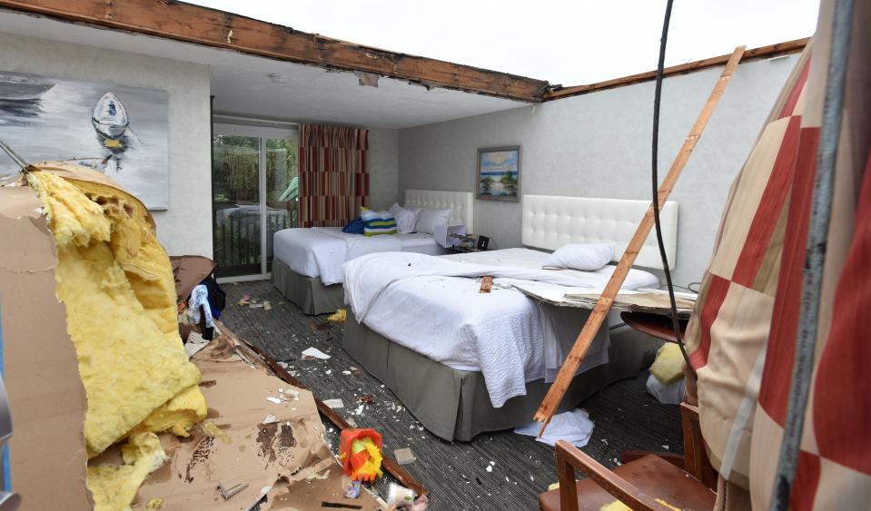
“You hear of tornadoes happening in different parts of the country and you have empathy and compassion for those who have lost so much, but on Cape Cod (a tornado) was unheard of,” said Lorraine Blute, who lives near Harwich Center, where a tornado touched down around 11 a.m. on July 23, 2019, causing an estimated $3.6 million in property damage.
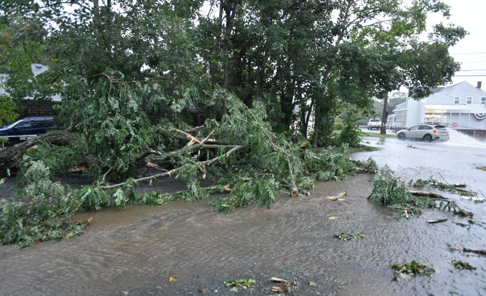
From 1951 to 1977, the Cape and Islands had only three verified tornadoes. But the frequency has picked up in recent years, with five since 2018. Unlike the hurricanes and nor’easters the region is accustomed to, tornadoes come with little time for disaster preparedness.
Blute said the warning gave them just 15 minutes to find shelter.
Rare Cape Cod tornado
“It was very eerie. There was silence, and everything went so dark, and then, when you heard the wind, it was so sudden. You could hear the trees cracking and then it stopped,” Blute said. “It was overpowering, but for a very short time.”
It would be tempting to blame climate change for the Cape’s increased tornado sightings. A recent study by researchers from Salem State University and the University of Massachusetts Amherst found that New England is warming faster than most of the world — on land and at sea — and has already surpassed the global heat benchmarks of 1.5 degrees Celsius and is approaching the 2 degree mark that the Intergovernmental Panel on Climate Change set as the limit to avoid a dramatically altered world.
Another UMass study showed that in the past decade the region had four of the five warmest autumns ever recorded and Boston’s average temperature this past year was the highest on record.
“Conditions are more favorable (for tornado formation) than they were 40 years ago,” said Victor Gensini, an extreme weather researcher at Northern Illinois State University. Research has shown that while the number of significant tornadoes (EF2 rating or greater with winds above 113 mph) has remained relatively flat, Gensini said their location has shifted to the east, towards more populated areas of the country.
“Places like New England are becoming more favorable. Conditions supportive of extreme storms have become more favorable,” he said. Plus, as cities grow and the human footprint expands, there are simply more bullseyes for extreme storms like tornadoes to hit.
“While the chances (of tornado formation) are fairly low in the Northeast, any increase at all is fairly significant,” Gensini said.
Favorable conditions explained
The U.S. has more tornadoes than any other region on earth. These vertical columns of rotating air depend on specific conditions to develop, and the U.S. has particular geographic features favorable to tornadoes.
In the relatively flat expanse of the Great Plains, a layer of warm moist air flowing north from the Gulf of Mexico is topped by a sheet of cooler, drier air coming over the mountain ranges to the west. This makes for unstable atmospheric conditions as the warmer, lighter air tries to rise up through the cool, dense layer above.
This instability is conducive to thunderstorm formation and the increased likelihood of extreme weather. When upper level winds flow in a different direction from surface winds, they impart the spin that creates supercells — the seeds of tornado formation.
Massachusetts averages one to three tornadoes a year, said Matthew Belk, a meteorologist at the National Weather Service in Norton. Belk said it is nearly impossible to tease out the climate change impacts on tornado formation, which are the products of rapidly evolving, highly local weather conditions that are short-lived and occur in a relatively small geographical area.
Plus there is what Belk calls an observational bias in reporting. In Franklin County, he said, where there are fewer people and large undeveloped tracts of land, there’s less likelihood of someone witnessing a tornado.
“We tend to see reports cluster around where we see people living,” he said.
While he didn’t have data available to show whether tornado warnings had increased, he said the recent development of a Doppler radar network — particularly the dual polarization upgrade over the past decade — allows meteorologists to see storm development on both the vertical and horizontal planes.
“Within my career, spanning 30 years, we do tend to issue more warnings because the radar is better,” Belk said. Knowledge of what severe weather looks like, more accurate and timely pinpointing of individual storm cells, and better communications has also affected the number of warnings and confirmed tornadoes.
“I chased that one,” longtime meteorologist Tim Kelley said of the tornado that touched down briefly in Dennis on Sept. 2, taking down trees and blowing out a sunporch window in the area of East Bay View Road and Wampanoag Trail. He questioned whether the Dennis tornado would have even been reported as anything but a severe thunderstorm without Doppler radar.
With the Cape located on the boundary between northern and southern warm and cold water and air systems, it’s harder to say what will happen here on any given day.
“Microscale little supercells form sometimes without any warning,” Kelley said. “It’s challenging to predict them and you cannot just say it’s due to climate change.”
Tornadoes slam multiple towns in '19
Kelley recalled the weather conditions that spawned the tornadoes on July 23, 2019.
Ocean temperatures were warm and the sun came out in the morning, creating a buoyant air mass over the Cape. When a strong low pressure system racing along the southern New England coastline hit a stalled warm front over the Cape, it gave the rotation to the rising air needed to produce the tornadoes, Kelly said.
On that July day, Harwich resident Ed McManus had just sat down for lunch at his Parallel Street home after spending the morning clearing the yard of downed branches from a burst of high winds the previous night that also came with a tornado warning.
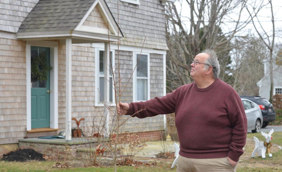
When cellphones and the television erupted that morning with warnings for the second time in two days, it didn’t register immediately, McManus said. He was a little slow to respond and the sky suddenly turned black as though the lights had been turned off.
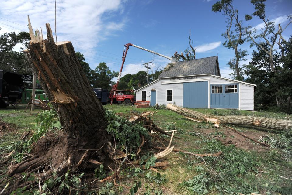
A day that had been eerily calm erupted in a sudden violent wind that quickly uprooted an 85-foot-tall catalpa tree in his front yard, stripping the limbs off a 30-foot liquid amber tree and collapsing the roof over his front steps as it fell.
Those July tornadoes hit Barnstable and Yarmouth before touching down near McManus’ house with 110 mph gusts, and caused an estimated $8.53 million overall property damage from affiliated storms from Mashpee on up to Chatham, according to National Weather Service data. There were no fatalities.
Devastating Mayfield, Kentucky tornado
But that’s a far cry from the Mayfield, Kentucky, tornado, which had wind speeds over 190 mph and was one of 52 tornadoes that ravaged six states Dec. 9-12. Nearly 90 people were killed, thousands displaced from homes, with a preliminary estimate of $3 billion to $5 billion in insured property damage — with as much as $18 billion in total property losses.
Was the tornado that hit Mayfield an EF5: Here's how the National Weather Service decides
The strongest documented tornado to hit the Cape and Islands was an EF2, with a wind speed of between 113 and 157 mph, that hit Martha’s Vineyard in the Katama section of Edgartown near the airport in 1951, said Charles Orloff, executive director of the Blue Hills Observatory in Milton. He noted that the ocean sea surface temperature was 77 degrees on July 23, 2019, and that helped produce the warm buoyant air mass conducive to tornado formation.
The Cape is surrounded by a rapidly warming ocean and Orloff thinks the 2019 tornado year could become the norm as air and sea temperatures continue to climb. But with a history of rather weak tornadoes, does the Cape’s unique location offer some kind of protection from the big ones, like the Mayfield, Kentucky, tornado that cut a mile-wide swath of total devastation over a 163-mile path.
Formation of large, dangerous tornadoes is more a function of local weather conditions at the time, experts said. Massachusetts has had four documented tornadoes of the same force rating as the Mayfield storm.
'Completely devastated': Kentucky town left mourning, in ruins after catastrophic tornado
Strong tornado can reach 200 mph
A June 1, 2011, tornado that hit Hampden County in Western Massachusetts was an EF3 tornado with winds above 150 mph that stayed on the ground for 70 minutes and destroyed homes, apartments, schools and trees, including catastrophic damage to the town of Monson. Three people died, nearly 300 were treated for injuries and insurance claims totaled $175 million in damage.
Gensini said big tornadic thunderstorms can move over water and hit the Cape. He said the level of damage to properties, and fatalities, is more a factor of building codes and construction.
“If you get a strong tornado of 150 to 200 mph, it will destroy the structure. The key though is fatalities and injuries. Most occur in weak frame structures. Fifty percent of all fatalities occur in mobile homes,” Gensili said.
Experts agreed that the science that links climate change to tornado intensity, frequency and location is still in its infancy. Weather is day-to-day and climate covers long periods of time that we don’t have a lot of documentation for, Belk said.
But could a tornado of the size and impact of the Kentucky storm happen in New England — or on the Cape?
“Yes, it’s harder to get those ingredients, but it can happen, just like you could get a Category 5 hurricane, but it’s harder to do,” Gensini said. Still, recent climate change trends do point to conditions like rising sea and air temperatures and moisture in the air in the Northeast that are more conducive to tornado formation, he said.
“It only takes one event. All it takes is one Mayfield, Kentucky, to plow through New England to make for a very bad day,” Gensini said.
Contact Doug Fraser at dfraser@capecodonline.com. Follow him on Twitter: @DougFraserCCT.
This article originally appeared on Cape Cod Times: Could Cape Cod see a Mayfield, Kentucky tornado? Experts say possible

