What does a ‘cone of uncertainty’ mean? What to know about a Hurricane Ian descriptor
The severe weather impact of hurricanes can be tough to predict, but a tool used by the National Hurricane Center gives meteorologists an idea of where storms are headed.
The cone graphic -- seen in online maps and TV weather broadcasts during storm season -- outlines the possible path of the center of a storm like Hurricane Ian and shows the areas that could be affected.
But the image created by the National Hurricane Center is sometimes referred to as the “cone of uncertainty” because of the margin of error involved in forecasting.
Here’s how cones are created, how accurate they are, and what it means for Charlotte.
How is the storm cone created?
To form the cone, a set of imaginary circles are plotted along a forecast track every 12 hours up to five days before a hurricane is expected to make landfall, NHC said.
The size of each circle grows larger with every forecast interval because errors in the position of a storm’s center increase with time, according to the NHC. The cone is formed by connecting the area swept out by the circles.
How accurate is the cone?
The track of a storm remains within the cone up to 70% of the time based on predictions from previous years, according to the NHC.
There is an average landfall error of 200 miles on forecasts five days out from when a hurricane is expected to make landfall, according to the NHC. The average error drops to 26 miles when a storm is 12 hours away from making landfall.
What does the cone predict for Hurricane Ian impact for Charlotte?
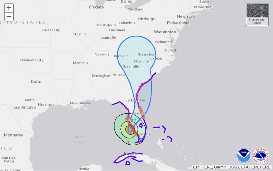
According to the NHC’s interactive map of Hurricane Ian’s path, the solid white area in the cone represents the track forecast uncertainty for the first three days of the forecast, while the dotted white area depicts uncertainty on days four and five.
Charlotte is currently in that area along with all of western North Carolina.
Strong winds from the storm could arrive in Charlotte as early as 8 p.m. Friday, according to the map, but the NHC notes that “winds can extend well beyond what white areas shown enclosing the most likely track area of the center” of the storm.
Charlotte could also get up to four inches of rain from the storm, according to the rainfall forecast map from the NHC.

