One rowdy storm leaves Atlantic Canada in time for another this weekend
An intense system that brought soaking rains and high winds to Atlantic Canada will deal out its final parting shot across Newfoundland overnight Thursday before conditions calm down to round out the week.
Don’t let your guard down too much, though—another storm is on its way this weekend.
SEE ALSO: Triple-dip La Niña and polar vortex to deliver a frigid start to winter
Winds of 90-100 km/h ripped across parts of Atlantic Canada on Thursday, knocking out power to tens of thousands of customers throughout the Maritimes and closing the Confederation Bridge for a time early Thursday morning.
Well, hurricane season is officially over but it's 11°C and this is my view in Nova Scotia this morning. pic.twitter.com/T0l0aVZtnZ
Well, hurricane season is officially over but it’s 11°C and this is my view in Nova Scotia this morning. Nathan Coleman on Twitter: "Well, hurricane season is officially over but it's 11°C and this is my view in Nova Scotia this morning. pic.twitter.com/T0l0aVZtnZ / Twitter"
— Nathan Coleman (@NateTWN) Nathan Coleman on Twitter: "Well, hurricane season is officially over but it's 11°C and this is my view in Nova Scotia this morning. pic.twitter.com/T0l0aVZtnZ / Twitter"
Gloomy weather will continue across Newfoundland as we head through Thursday night into Friday morning. The worst weather will be confined to eastern Newfoundland, including the Avalon Peninsula, where rain and winds will continue as the system’s front departs out to sea.
Sea-effect snow will continue into Friday morning for some coastal communities in western Newfoundland.
WATCH: Transformer explodes as 100+ km/h gusts leave thousands in the dark in N.S.
This won't be the end of the stormy weather, either, as another late-fall-like storm will track north of the region this weekend. This will bring another round of rain, spreading from west to east across the region late Saturday through Sunday.
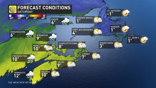
Double-digit temperatures will once again surge across much of the Maritimes Saturday before they fall on Sunday. Another round of unsettled weather is expected mid- or late next week.
Stay tuned to The Weather Network for the latest forecast updates for Atlantic Canada.

