Powerful wind threat as rain turns to snow in southern Ontario
After waking up to what feels more like a spring day in southern Ontario, temperatures will take a fast and steady tumble as a strong cold front moves through.
Visit our Complete Guide to Winter 2022/23 for an in-depth look at the Winter Forecast, tips to plan for it, and much more!
Mild conditions, heavy rain and even loud rumbles of thunder started the day early Wednesday, with some weather stations reporting double-digit temperatures across the southwest. By Wednesday night however, expect temperatures to drop below the freezing mark as powerful winds whip through the region and rain turns over to snow.
Special weather statements and wind warnings were issued ahead of the intense gusts expected. There are also snow squall watches in effect for heavy flurries set to pick up later Wednesday night.
"Strong winds may toss loose objects and cause tree branches to break. Isolated utility outages may occur," says Environment and Climate Change Canada (ECCC) in the statement.
During the transitional period, winds are forecast to sweep across southern Ontario with gusts between 60-80 km/h expected, and locally near 90 km/h along the shorelines of the Great Lakes, focused near Niagara, Prince Edward County, Kingston and the shores of Lake Huron.
The winds will peak in the late afternoon and evening hours.

As well, the Grand River Conservation Authority (GRCA) has issued a high Lake Erie level flood watch message due to the anticipated storm surge model forecast for the eastern end of the waterway. The message is in effect until 8 a.m. on Thursday, Dec. 1.
"The public is reminded to stay away from the Lake Erie shoreline due to the potential for strong wave action and elevated water levels. Follow the direction of local flood co-ordinators and emergency officials. Parents are reminded to keep children and pets away from these areas," GRCA said in the watch.

Temperatures tumble in the wake of a strong cold front
The rain will ease from west to east through the afternoon, with a transition over to snow expected by Wednesday evening.
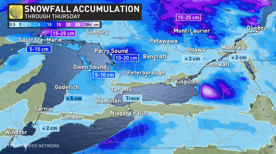
Snow squalls are forecast to start up behind the cold front, bringing bursts of snow overnight Wednesday and into Thursday. At times, these squalls may stretch into the Greater Toronto Area, but the focus of them should remain in the traditional snow belt regions.
Localized, heavy snow and whiteout conditions are likely during this time and drivers are urged to consider postponing non-essential travel until conditions improve.
Conditions will ease for the second half of Thursday, with a fairly quite Friday before a rinse and repeat system will sweep across the region again giving more rain, gusty winds and a transition to snow flurries through Sunday.
Seasonal temperatures and fair conditions return early next week, but forecasters will be watching the potential for another Colorado low for the mid-week mark. A more consistently cold pattern is expected after Dec. 7.
Stay tuned to The Weather Network for the latest forecast updates in southern Ontario.

