Some areas under flood watch; rain, chance of severe storms in Dallas-Fort Worth forecast
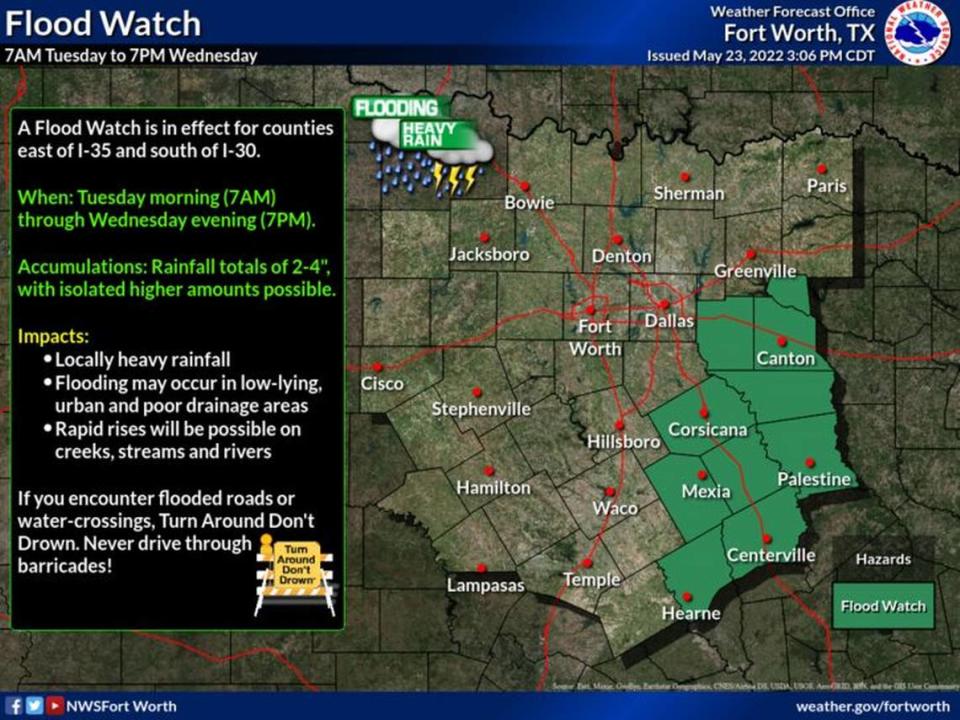
Areas southeast of the Dallas-Fort Worth Metroplex are under a flood watch Tuesday morning, as a cold front continues to travel across the region, bringing up to 4 inches of rain.
“A flood watch is in effect for counties east of I-35 and south of I-30 from Tuesday morning through Wednesday evening,” the National Weather Service said. “Rainfall amounts of 2-4 inches are expected, with isolated higher amounts possible. Make sure to never drive through barricades or flooded roadways. Turn Around. Don’t Drown!”
The weather service said the hardest rain is expected to hit the following cities: Canton, Coriscana, Palestine, Mexia, Centerville and Hearne. The flood watch that began around 7 a.m. Tuesday will remain in place until 7 p.m. Wednesday.
North Texas has been upgraded to an Enhanced Risk (level 3 of 5) for severe storms today. Numerous storms are expected. Some storms have the potential to produce hail, damaging winds, and a few tornadoes along with a risk for flooding. #wfaaweather pic.twitter.com/jcNuBjEEJv
— WFAA-TV Weather (@wfaaweathertoo) May 24, 2022
In Dallas-Fort Worth, Tuesday morning temperatures are expected to remain around the high 60s, before gradually warming into the 70s or low 80s by mid-day with the chance for storms in the forecast as well.
“Good chances of showers and storms enter the picture today associated with an upper level storm system and a cold front. Storms should form across the northwest late morning and early afternoon, then push southeast through the region during the late afternoon and evening,” the National Weather Service said. “Some storms could be severe with damaging winds and hail. A few spin-up tornadoes are also possible. Locally heavy rain may also occur in the stronger storms. Activity should exit to the southeast late tonight or early Wednesday morning.”
After storms Tuesday and Wednesday, the weather service predicts warmer temperatures, back into the 90s, by Saturday.
“An upper ridge will strengthen across the area for seasonably hot temperatures by the weekend into early next week. Highs in the upper 70s and 80s will warm mostly into the 90s this weekend, though a few readings across the Big Country will top the century mark each afternoon,” the weather service said. “Breezy northwest winds 10 to 20 mph on Thursday will become south-southeast at 15-20 mph and gusty by the weekend into Monday.”
3-Day Storm Outlook
This map shows the 3-day weather outlook for storms by the National Weather Service's Storm Prediction Center. Sources: National Weather Service, Esri.

