Which areas of US are in for it this winter? Here's the full forecast


It's that time of year again. The days are growing shorter and the temperatures are dropping, which means it's only a matter of time before the arrival of winter. As some welcome the return of snow, others may be wondering what the coldest time of the year has in store - and AccuWeather meteorologists have the answers. That's right -- it's time for the annual AccuWeather winter forecast.
Last winter was one that will not soon be forgotten, especially in the central U.S. where a snowstorm followed by extremely cold air left millions in the dark across Texas. Just days later, 73.2% of the country measured snow on the ground, the highest percentage since record-keeping on that metric began in 2003. Additionally, Denver experienced its snowiest winter in 37 years.
AccuWeather's team of long-range forecasters, led by Senior Meteorologist Paul Pastelok, has made its annual prediction for the upcoming winter season, giving people all across the country time to prepare for what is expected to be a busy winter from coast to coast. AccuWeather is predicting some similarities this year compared to last winter due to a weather phenomenon known as La Niña.
 |
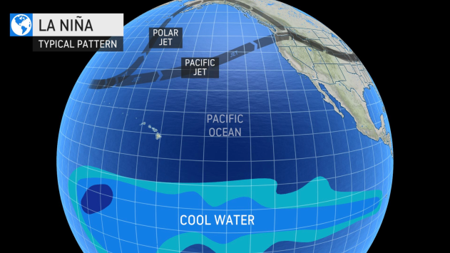
An illustration showing how water temperatures far out in the Pacific Ocean can influence weather patterns thousands of miles away. (AccuWeather) |
Last winter, La Niña was a driving force that shaped the weather patterns across the country throughout the season. La Niña is a phenomenon that occurs when the water near the equator of the Pacific Ocean is cooler than average. In turn, this influences the jet stream and the track that storms take when moving across North America. It is also the counterpart to the more well-known El Niño.
La Niña is once again predicted to shape part of the overall weather patterns this winter, but Pastelok said that the upcoming La Niña will be weaker than the one experienced last winter. This "opens up the door" for other elements to factor into the winter forecast, especially during the second half of the season.
There are also indications entering this winter season that, unlike last year, the polar vortex can be weaker. This could allow colder air from the Arctic to slide southward into the U.S. before the official start of meteorological winter, which is on Dec. 1. Astronomical winter, the first official day of winter, arrives on Tuesday, Dec. 21.
Take a look at the complete region-by-region breakdown of the U.S. winter forecast below:
Residents across the northeastern U.S. might want to dig out their winter coats sooner rather than later as winter weather could make an early arrival across the region this year.
"This winter, I think, is going to be a colder one, at least for the interior sections from the Appalachians to the Ohio Valley and Great Lakes," Pastelok said. Last winter, temperatures across these areas were right around normal, but this year, the winter as a whole is likely to average 1 to 3 degrees Fahrenheit below normal.
The first waves of cold air are anticipated to chill the Northeast in November when Pastelok said there could be "a couple of rounds of cold weather and some snow," particularly across the interior Northeast. The chance of a plowable snow is also anticipated to start early in the season with the early waves of cold air.
Areas closer to the coast, such as Boston, New York City and the rest of the Interstate-95 corridor, could also get the chance of early-season cold and snow, but it is not predicted to be as cold or as snowy as across areas farther inland.
The early arrival of chilly air will be just the first hill on the roller-coaster weather ride that is expected this winter.
 |
A pedestrian crosses South Broad Street as snow falls in Philadelphia, Wednesday, Feb. 20, 2019. (AP Photo/Matt Rourke) |
The severity and frequency of the snow and cold air are likely to let up a bit by mid-December before returning with a vengeance in January.
"That's the month that stands out," Pastelok said. Heating bills could hit their highest point in January and people all across the Northeast, especially those who live along and west of the Appalachian Mountains, may notice the effects. This will come at a time when heating costs could be inflated anyway. The price for natural gas as of late September was up 180% compared to 12 months ago, CNN reported. At the time of the report, natural gas prices were at their highest since early 2014.
This is also the period of the winter when there will be ample cold air entrenched across the region for snowstorms to cause widespread disruptions.
Sometimes during January, there is a period during which the cold air lets up, referred to by some meteorologists as a "January thaw." But this coming winter, that respite from the frigid weather could occur a few weeks later, making it more of a "February thaw."
This will provide a window for snow and ice to melt before the end of winter when the polar vortex could pay a visit.
Winter could go out like a lion with another heightened risk for nor'easters at the tail end of the season.
"At the end of the winter into early spring, there could be another attempt of the polar vortex being displaced or split," Pastelok said. This would send frigid Arctic air blowing across the eastern U.S., extending the wintry weather well past March 1, which marks the beginning of meteorological spring.
 |
After measuring less than 1 inch of snow in the entire winter of 2019-2020 in Philadelphia, snowfall during the winter of 2020-2021 ended up being slightly above normal. This could be the case again this winter for the City of Brotherly Love with near- to slightly above-average snow in the offing.
A different story is likely to unfold a short drive south on I-95 with another below-normal year for snowfall in the nation's capital. AccuWeather is predicting between 7 and 11 inches of snow for the winter in Washington, D.C., which is slightly more than the 5.4 inches that fell last winter but still below the average of 15.6 inches. The city hasn't measured above-normal snowfall since the winter of 2018-2019.
Boston was another major I-95 city that ended up with less snowfall than average last winter, with a total of 38.6 inches compared to an average seasonal snowfall of 44.3 inches. This year, above-normal snowfall is expected, and amounts could reach as high as 55 inches.
Similar to the Northeast, folks across the Great Lakes and the north-central U.S. should brace for a colder-than-normal winter with snowy spells throughout most of the season.
"It's going to be a busy one in the northern Plains and Great Lakes this year," Pastelok said, adding that the regions will get a combination of bitterly cold air and above-normal snowfall.
Winter will start off strong with snowstorms tracking from the foothills of the Rockies through the Great Lakes, providing early-season snow for many of the favorite snow-related activities, such as skiing, snowmobiling or winter-themed festivals.
 |
Closer to the Great Lakes, the big story this winter will be lake-effect snow.
"Lake-effect snow in the Great Lakes --- look out," Pastelok warned. "If it all does come together, we could have a pretty busy season as far as lake-effect snow [goes] for all of the Great Lakes."
The first rounds of lake-effect snow are likely to start in late November and into December, but the pattern that meteorologists often refer to as "the lake-effect snow machine" will kick into high gear as the calendar turns to 2022.
One reason the worst of the lake-effect snow is expected to hold off until January is the state of the Great Lakes heading into the season. The water temperatures in all five lakes as of late September were above normal. Water temperatures were about 1 degree Fahrenheit above normal in Lake Erie and Lake Ontario, about 2.5 F above normal in Lake Huron and Lake Michigan, and 5 F above normal in Lake Superior, according to NOAA Coast Watch.
As of late September, some of the warmest waters in the Great Lakes were concentrated in Lake Erie, where readings at stations on the coast of Cleveland and Buffalo topped 67 degrees. In the southern parts of Lake Michigan, near Chicago, water temperatures remained above 60 degrees at the end of September.
With only intermittent intrusions of cold air before a persistent flow of Arctic air in January, the lakes will remain open for business well into winter.
Buffalo, New York, is predicted to measure around 100 inches of snow this winter, slightly above the average of 95 inches and noticeably above last season, during which the city measured a total of 77 inches.
 |
Farther west, the bigger story will be the unrelenting waves of cold air.
"If you live in the northern Plains and Great Lakes, I think you really have to pay attention to the cold shots that come down," Pastelok said referring to Arctic air blasting down from Canada.
Temperatures in January could end up being 5 to 10 degrees Fahrenheit lower than they were last winter across the Plains -- and the Arctic air is likely to remain in place over the region into February.
Winter weather will take its time arriving across the southern U.S., but that doesn't mean that people in that part of the country should let their guard down.
December could end up being rather mild from Texas through Florida with the first frost of the season occurring later than normal. Near the central Gulf Coast, the first frost is predicted to take place after Nov. 15, which is later than normal. In parts of southern Texas and central Florida, the first frost may not occur until after the start of December.
However, a big flip in the weather pattern is expected shortly after the start of 2022.
 |
Pastelok said his team sees similarities to last year's pattern with another major cold snap potentially unfolding across the southern Plains this winter around late January or in February. The cold snap has the potential to be highly disruptive but not something on the historic level that was blamed for more than 200 fatalities last February.
A recent study published in the journal Science revealed a connection between the weather disaster in Texas last winter and climate change in the Arctic. Last February, the south-central U.S. was hit by devastating winter storms. Texas in particular was hit hard in February after extreme winter weather left millions without power for days and caused over $150 billion in damages, according to AccuWeather estimates.
In addition, some of the most extreme cold could envelop places farther to the east of those that took the worst of the cold snap last February. This winter, Pastelok is highlighting eastern Texas, eastern Oklahoma and Arkansas as the areas that could experience the worst of the cold and potential winter storms across the region. This includes some of the areas that experienced the deadly winter weather last February.
 |
People walk down a street during a winter storm in Oklahoma City, Sunday, Feb. 14, 2021, in Oklahoma City. Snow and ice blanketed large swaths of the U.S. on Sunday, prompting canceled flights, making driving perilous and reaching into areas as far south as Texas' Gulf Coast, where snow and sleet were expected overnight. (AP Photo/Sue Ogrocki) |
Farther east, the wintry weather is not anticipated to be as bad, but the risk of severe weather will loom throughout the season.
The primary storm track over the southern U.S. will send spells of rain and thunderstorms across the lower Mississippi and Tennessee valleys with the highest chance of severe weather focusing on a zone from Louisiana to Tennessee.
This is the same region that experienced a few rounds of severe thunderstorms late last winter. That was capped by the first "high risk" of severe weather in March in nine years. Louisiana, in particular, has been hit extremely hard by the weather over the past year and a half, dating back to Hurricane Laura and Hurricane Delta in the 2020 Atlantic hurricane season, severe flooding this past spring and Hurricane Ida over the summer.
 |
Meanwhile, in the Southeast, the Atlantic coast is predicted to enjoy mild weather with drier-than-normal conditions. Places in Florida, like Miami and Jacksonville, up through Charleston, South Carolina, and Wilmington, North Carolina, could all receive below-average precipitation this winter.
A La Niña winter typically translates to a stormy season for the Pacific Northwest, and while La Niña is in the offing this winter, it may not trigger as much stormy weather as in years past.
"La Niña may not come and do the same things that we typically see because it's weaker," Pastelok explained.
A wet winter is still anticipated with plenty of snow in the mountains, but it might not total as much as last winter, and more breaks in the stormy pattern are projected. Still, there will be enough precipitation to lay down a healthy snowpack for ski resorts across the Pacific Northwest and the northern Rocky Mountains.
Snow from these storms could blanket Denver, but the city is not likely to have a repeat of last winter, which was the snowiest in 37 years with more than 80 inches of snow accumulating throughout the season. Snowfall this season in Denver should be closer to normal, which is 56.5 inches.
 |
The early arrival of the winter storms will spell an end to the active wildfire season for the Pacific Northwest as rain and snow help to douse any flames that are still burning across the region. It will also help to saturate the parched ground following a dry summer.
Seattle endured its driest spring and summer in 77 years with the Emerald City experiencing just 41 days with rain, the lowest on record.
CLICK HERE FOR THE FREE ACCUWEATHER APP
In the long term, the winter storms will help with the drought that has developed across the region. Most of the Northwest and the northern Rockies as of late September were experiencing extreme to exceptional drought conditions, according to the U.S. Drought Monitor.
"I do feel that the drought will improve. It's already improving in parts of Washington and northern Idaho, but it's not going to be a drought-buster," Pastelok said of the expected precipitation amounts this winter.
The amount of rain and snow that falls during the latter part of the winter will have implications well into 2022, especially over next summer and autumn following two active wildfire years in a row. If the wet season ends on a dry note, then it will allow the vegetation more time to dry out before the start of wildfire season, resulting in more fuel for fires that ignite.
As waves of storms start to soak the Pacific Northwest periodically through autumn and into the first part of winter, people who live across areas farther south may be wondering when meaningful rain will reach California and the rest of the Southwest.
"Through November and December, I do not see much in the way of significant systems getting down to Southern California," Pastelok said.
The lack of early-season precipitation will allow the ongoing wildfire season to extend all the way into December, an unusually late end to the season.
Several major fires were burning across California during late September, including one complex that scorched part of Sequoia National Park. Firefighters wrapped the largest tree on Earth in aluminum blankets to help it survive the intense blazes.
More fires will be possible across the Sierra and elsewhere in California before the arrival of the wet season.
 |
Flames burn up a tree as part of the Windy Fire in the Trail of 100 Giants grove in Sequoia National Forest, Calif., on Sunday, Sept. 19, 2021. (AP Photo/Noah Berger) |
As the calendar turns from December to January, the prospects for rain will increase for California. Typically during La Niña, storms from the Pacific Ocean generally track toward Washington and Oregon, leaving California high and dry, but a different story may unfold later this winter.
"This is not a typical La Niña," Pastelok said, adding that as La Niña weakens later in the winter, it will allow other factors to influence the storm track.
This will open the door for meaningful precipitation across California during the second half of the winter, but Pastelok warns that what does come down is "not going to be a drought buster."
The lack of persistent storms will lead to most of California and the rest of the Southwest being milder than normal this winter, although a few cold spells can't be ruled out, particularly across the interior Southwest.
 |
Pastelok said that there are some chances for storms to dive down from the Northwest across the Four Corners, bringing the chance of precipitation to the interior Southwest.
This will be beneficial for ski resorts across Utah, Colorado, New Mexico and Arizona, although these interior storms may not take place until later in December and into January.
Similar to California, the precipitation from these storms is not expected to end the long-term drought across the region, but it could bring minor relief in the short term.
The water level of Lake Mead reached its lowest level since the Hoover Dam was constructed this summer, and without significant precipitation, water levels could continue to decline.
"This is a long-term drought and it's going to hold unless something out of the ordinary happens here late in the winter and the wet season continues longer than normal," Pastelok said.
For the latest weather news check back on AccuWeather.com. Watch AccuWeather Network on DIRECTV, DIRECTVstream, Frontier, Spectrum, fuboTV, Philo, and Verizon Fios. AccuWeatherNOW is streaming on Roku and XUMO.
