AccuWeather: Storm now off Alaska could bring snow, wind to Southern New England this weekend
Forecasters are watching the possibility that a coastal storm could bring snow, gusty winds and coastal flooding to Southern New England late Friday into Saturday.
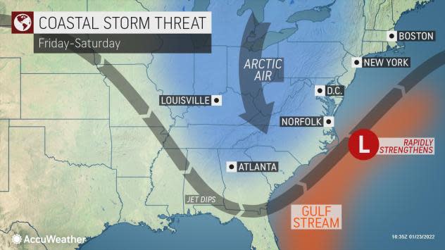
"A coastal storm may make a close pass or offshore of New England Friday night into Saturday night," the Weather Service says in its forecast discussion. "Impacts are possible but are still uncertain and will hinge on the storm's strength and a favorable track."
The potential storm is still several days away, and computer models are showing a variety of possibilities in the track, the Weather Service says.
"What we can say is that the risk of a coastal storm passing near or east of Southern New England continues to increase," the Weather Service says. "The effects or impacts we could see will vary significantly on storm strength and its track. But those include snow (which could be significant/heavy), gusty to potentially strong winds, and also a risk for coastal flooding as (astronomical) tides begin to rise late week into the weekend."
"We are just not at the point where we can confidently say how much or the extent to which each of these effects or impacts may affect our area," the Weather Service says. "Stay tuned!"
AccuWeather says the storm is currently near Alaska's Aleutian islands and could "pack a wintry punch from the Southeast to the Northeast late this week into next weekend."
More weather: Weather Service: Light snow overnight, cold could leave roads slippery morning
The storm "is expected to hitch a ride on the jet stream and travel southeast, diving through the Canadian Prairies and northern Plains by midweek."
"This storm could reach the southeastern U.S. late in the week and move off the Southeast Coast where it is expected to rapidly strengthen over the warmer Gulf Stream waters as a wave of Arctic air dives southward in the wake of the storm," AccuWeather says.
Wanna have a snowball fight?: Watch out — it's illegal in 8 cities and towns in Rhode Island
The storm's track presents "the big question," according to AccuWeather.
AccuWeather Senior Meteorologist Brett Anderson offered the following two scenarios:
"If the jet stream becomes highly amplified over the Southeast late this week, that would force the storm to track close to the coast which could potentially bring significant snow and wind from the southern Appalachians through the Middle Atlantic and Northeast regions late Friday through Saturday."
"On the other hand, if the jet stream ends up being less amplified, then the storm will be slower to strengthen would likely remain far enough out at sea to prevent major impacts along the Eastern Seaboard," AccuWeather says.
Before the potential weekend storm, Southern New England should see a brief period of light snow Monday night into the early morning hours Tuesday.
"High pressure brings a shot of Arctic cold for Wednesday into Wednesday night, with some moderation into Thursday," the Weather Service says.
jperry@providencejournal.com
(401) 277-7614
On Twitter: @jgregoryperry
Be the first to know.
Sign up for our breaking news alerts
This article originally appeared on The Providence Journal: Forecasters say storm could bring heavy snow, gusty winds this weekend
