Winter weather, up to a foot of snow returning to Sioux Falls over next several days
After a streak of unseasonably warm temperatures earlier this year, the National Weather Service is forecasting the Sioux Falls area will ring in spring with a winter storm that could bring as much as a foot of snow to the area.
A period of wintry weather is expected to begin late Thursday evening and continue through Friday morning, when Sioux Falls could see trace amounts of snow and freezing rain, with accumulation of less than half an inch expected.
A more significant weather system is expected to then enter the area on Saturday morning, bringing snow and drizzle through Tuesday evening.
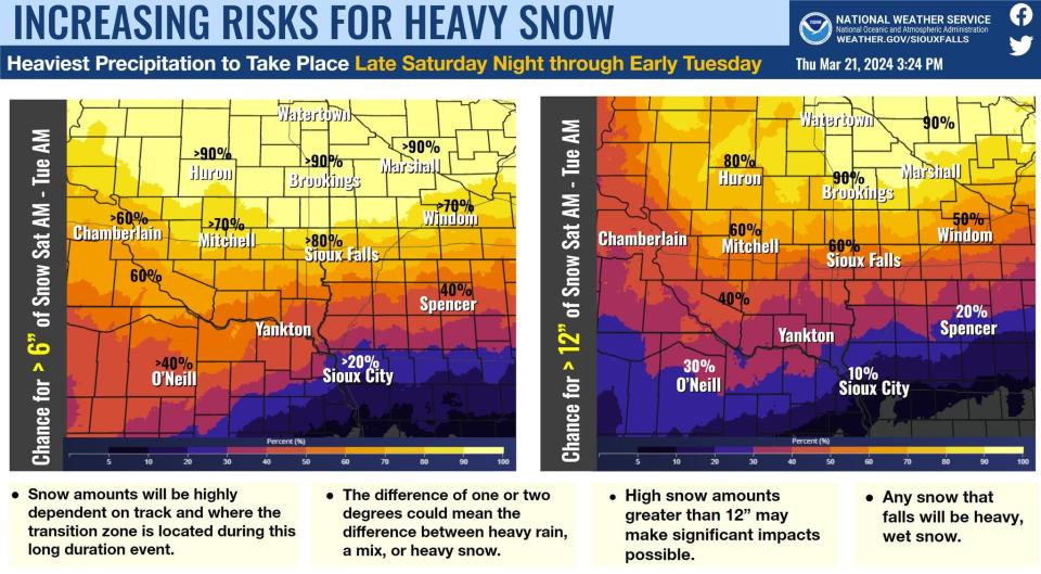
The forecast shows a more than 80% chance of getting more than six inches of snow from Saturday through Tuesday, with a 60% chance of more than 12 inches of snow.
The NWS emphasized the storm's exact track, along with how much precipitation it could bring, is still up in the air. The agency added the forecast would become more clear as the storm nears, stating, "the difference of one or two degrees could mean the difference between heavy rain, a mix or heavy snow."
Sioux Falls forecast
This Afternoon: Partly sunny, with a high near 48 degrees. Southeast wind around 15 mph, with gusts as high as 25 mph.
Tonight: Snow, possibly mixed with freezing rain before 4 a.m., then a chance of snow between 4 and 5 a.m., then a slight chance of snow and freezing rain after 5 a.m. Low around 26 degrees. East southeast wind 10 to 15 mph becoming northeast after midnight. Winds could gust as high as 20 mph. Chance of precipitation is 80%. Little or no ice accumulation expected. New snow accumulation of less than one inch possible.
Friday: Mostly cloudy, with a high near 38 degrees. North wind 10 to 15 mph, with gusts as high as 25 mph.
Friday Night: Partly cloudy, with a low around 19 degrees. North northeast wind around 10 mph.
Saturday: A 40% chance of snow. Mostly cloudy, with a high near 34 degrees. Southeast wind 10 to 15 mph, with gusts as high as 25 mph.
Saturday Night: Snow, mainly after 1 a.m. Low around 26 degrees. Breezy, with an east southeast wind 15 to 20 mph, with gusts as high as 30 mph. Chance of precipitation is 80%. New snow accumulation of less than a half-inch possible.
Sunday: Snow, possibly mixed with rain before 1 p.m., then rain and snow, possibly mixed with freezing rain and sleet. High near 39. Breezy. Chance of precipitation is 100%.
Sunday Night: Snow, possibly mixed with rain. Some thunder is also possible. Low around 28 degrees. Breezy. Chance of precipitation is 100%.
Monday: Snow, possibly mixed with rain. High near 35 degrees. Breezy. Chance of precipitation is 90%.
Monday Night: Snow likely, mainly before 1 a.m. Mostly cloudy, with a low around 11 degrees. Blustery. Chance of precipitation is 60%.
Tuesday: A 20% chance of snow. Partly sunny, with a high near 24 degrees. Blustery.
Tuesday Night: Partly cloudy, with a low around 4 degrees.
Wednesday: Mostly sunny, with a high near 34 degrees.
This article originally appeared on Sioux Falls Argus Leader: Sioux Falls snow forecast calls for up to a foot next week

