Winter storm on the way for central and southern Sask. this weekend: Environment Canada
Environment and Climate Change Canada says there's another winter storm set to hit much of central and southern Saskatchewan.
A low-pressure system in Montana is expected to bring up to 35 centimetres of snow and wind gusts in the 60 to 70 km/h range in parts of the province including Regina, Saskatoon, Moose Jaw and Swift Current during the next few days, according to a winter storm watch issued by the national weather agency.
Some other areas in northwest and central Saskatchewan like Meadow Lake, Prince Albert and Nipawin are under a special weather statement with 10 to 20 centimetres of snow and wind gusts of up to 60 km/h in the forecast.
Kayla Bilous, a meteorologist with Environment and Climate Change Canada, said the storm is expected to start impacting southwestern Saskatchewan on Saturday afternoon before tracking to the northeast.
She added the storm will bring poor visibility and create bad driving conditions.
"With the heavy and blowing snow, it is advised not to travel if you really don't need to travel," Bilous said.
"So I would say if you do need to travel, try to do it either [Friday or Saturday] before the heavy snow comes in on Saturday night."
Bilous also said if you decide to drive, it's important to go slow, keep your headlights on, not get too close to other vehicles and to have an emergency car kit when travelling.
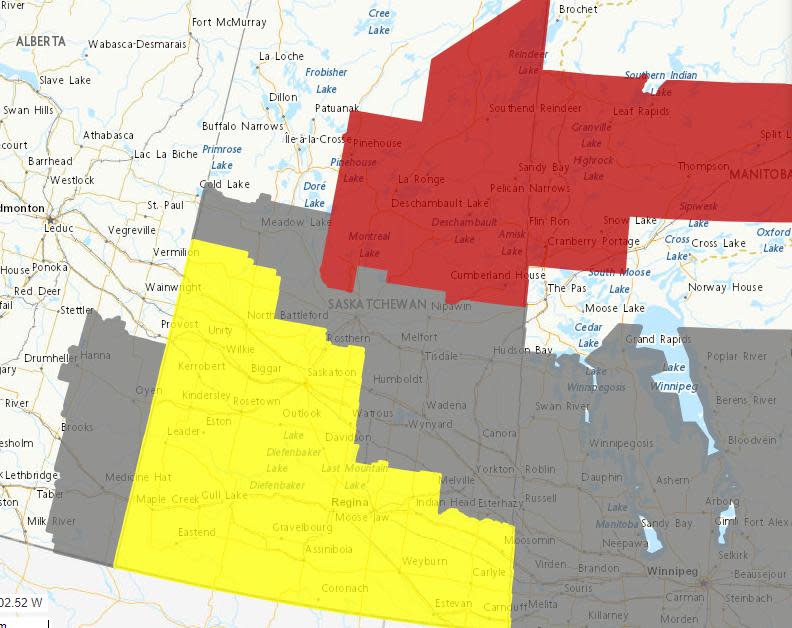
Environment and Climate Change Canada has issued a winter storm watch for areas in yellow, as of Friday morning. A special weather statement is in effect for areas in grey and a snowfall warning is in effect in parts of the north (in red). (Environment and Climate Change Canada)
She said it's important to keep an eye on the Environment and Climate Change Canada website because the watch will be upgraded to a winter storm warning or a blizzard at some point over the weekend.
"A blizzard warning is essentially our worst case scenario kind of warning — that is when we have sustained winds of 40 km/h or more and visibility is below 0.4 kilometres that lasts for at least four hours," Bilous said.
"If the conditions are expected to be any better than that, then we'll issue the winter storm warning."
The national weather agency states the winter storm conditions are expected to last until Monday night in parts of the province.
This forecasted winter storm is the latest development in a wacky week of weather in Saskatchewan that included a heavy snow dump, extreme cold warnings and temperatures rising into the positives in parts of the province on Thursday.
"It's definitely been a roller coaster of weather. It is pretty normal this time of year at … the shoulder seasons. We're trying to transition to spring here," Bilous said.
"We still have a lot of the influence of the Arctic air, so we have the cold air interacting with the warm air from the south and that's what is creating these fluctuations in the weather."
A different weather system prompted a snowfall warning in northeastern Saskatchewan Friday morning. The national weather agency states nearly 10 cm of snow is expected to fall before conditions improve in the afternoon.

