NWS issues winter storm warning for Spartanburg. McMaster declares state of emergency.
- Oops!Something went wrong.Please try again later.
The Herald-Journal is providing this important information about the winter storm free of charge. Please remember that your subscriptions to the Herald-Journal help us to provide this and more important journalism to our community. Thank you for reading, and please consider buying a subscription. For information, visit goupstate.com/subscribenow.
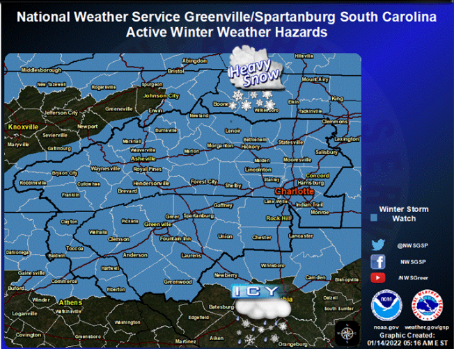
The National Weather Service has issued a winter storm warning for most of the Upstate and western North Carolina for Sunday.
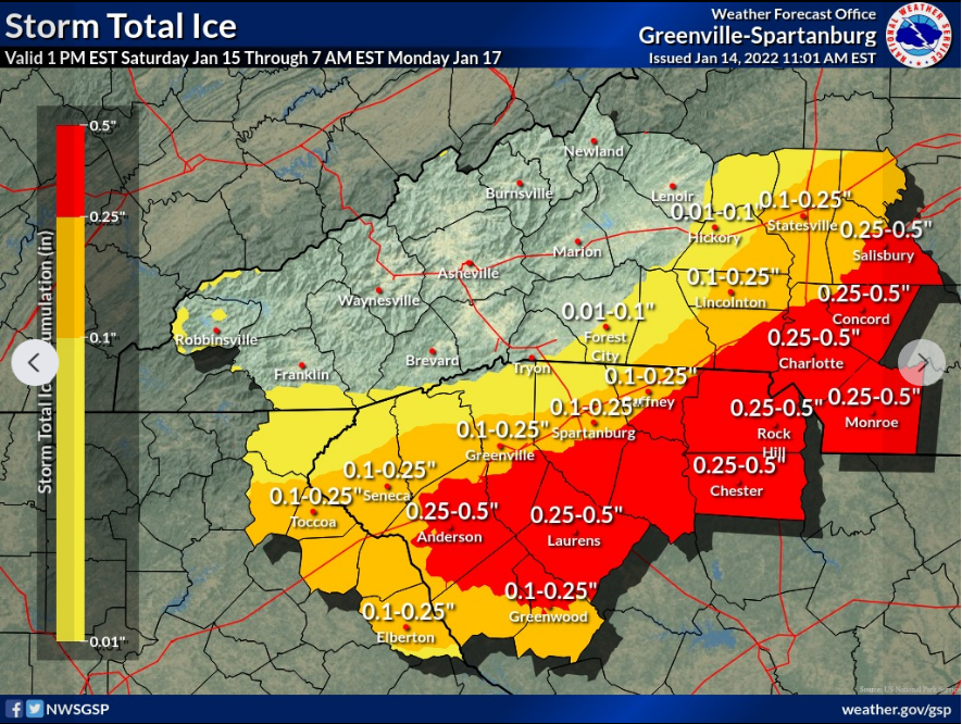
A total of 2 to 5 inches of snow and sleet is forecast for Spartanburg, with snow totals higher north of Interstate 85 and a mostly ice event south of I-85.

Accumulations of 6 to 12 inches are expected over the North Carolina foothills; 2 to 5 inches from northeast Georgia and South Carolina foothills through areas west of Charlotte.
One-quarter to one-half inch of ice accumulation with light sleet and snow is likely across the rest of the Carolina Piedmont.
Combined with wind gusts as high as 29 mph, downed trees and power lines will be a major concern, National Weather Service meteorologist Chris Horne said.
Late Friday afternoon, Gov. Henry McMaster declared a state of emergency for this weekend's winter storm and urged residents to monitor local weather conditions and take safety precautions.
"South Carolina will be impacted by a major winter storm this weekend," McMaster said in a press release. "There is a potential for very dangerous conditions caused by accumulations of ice and snow, which will likely result in power outages across the state."
The executive order puts into place the state's emergency plan in place that coordinates resources between state agencies.
Horne said although there is 100% chance of wintry mix Sunday, there is still some uncertainty as to where exactly the snow/ice line will be.
"It's going to be a dicey situation starting Sunday morning," Horne said. "The devil's in the details."
Just a couple days ago, forecasters believed all of the Upstate – including Laurens and Union counties – would be in store for a major snowstorm over the weekend, with up to a foot of snow.
At your fingertips: Everything you need to know about the snow forecast for Spartanburg, South Carolina
Since Thursday, snow expectations have turned to ice as models increasingly show higher chances of warmer air from the southeast moving closer to I-85, Horne said.
While temperatures in the atmosphere may be above freezing, especially south of I-85, Horne said ground temperatures will still be at or near freezing – meaning that even if rain falls, it will freeze on untreated surfaces.
The latest forecast for Spartanburg calls for mostly cloudy Saturday with a high near 44.
Rain and snow will arrive Saturday night, turn to snow and sleet between 1 and 4 a.m., then sleet after 4 a.m. The low will be around 28. Up to an inch of snow and sleet is expected.
Go figure: Wonder why local TV networks often make different snow predictions?
On Sunday, freezing rain and sleet are likely before 1 p.m., then snow and sleet between 1 and 4 p.m., then a chance of freezing rain after 4 p.m. The high will be near 31, with northeast wind of 9 to 17 mph and gusts as high as 29 mph. New snow and sleet accumulation of 2 to 4 inches is possible.
Sunday night will see a 30% chance of freezing rain before 7 p.m., then a chance of snow between 7 and 11 p.m.., with a low near 27.
Monday, Martin Luther King Day, will be sunny with a high near 42.
Monday night will be mostly clear with a low around 19.
Tuesday will be sunny with a high near 42.
The next chance of precipitation comes Wednesday night through Friday.
This is a developing story. Check back for more information.
Contact Bob Montgomery at bob.montgomery@shj.com
THE TIME TO PREPARE IS NOW: Damaging ice accumulations are likely in the piedmont and foothills of the western Carolinas and northeast GA, which will cause power outages, downed trees, and extremely dangerous traveling. Please take this system serious. #scwx #ncwx #gawx pic.twitter.com/fQjjMxukFG
— NWS GSP (@NWSGSP) January 14, 2022
This article originally appeared on Herald-Journal: Spartanburg SC winter storm: Snow, ice accumulation forecast from NWS

