Evacuation order issued as wildfire threatening Fort McMurray draws closer
Thousands of residents in the Regional Municipality of Wood Buffalo have been ordered to leave their homes as a wildfire burning southwest of Fort McMurray continues to draw closer to the community.
Communities across Fort McMurray are being evacuated to allow for fire suppression efforts, the Regional Municipality of Wood Buffalo said in an emergency alert Tuesday afternoon.
The evacuation order is in effect for the neighbourhoods of Beacon Hill, Abasand, Prairie Creek and Grayling Terrace.
All residents in the evacuation zone must leave the area by 4 p.m. MT, the municipality said.
The neighbourhoods under evacuation are most at risk. Crews will be better able to defend these areas if they are empty and inhabited, municipal officials said.
People who are unable to evacuate themselves are being asked to report to designated muster points, where transit buses will be on standby to bring evacuees and their pets to safety.
An evacuation alert remains in effect for Fort McMurray, Saprae Creek, Gregoire Lake Estates, Fort McMurray First Nation #468, Anzac, and Rickards Landing Industrial Park. People in these areas should be prepared to leave on short notice if the risk from the fire escalates.
Residents not in the evacuation zone are being encouraged to remain in place to allow for a safe evacuation of neighbourhoods most at risk.
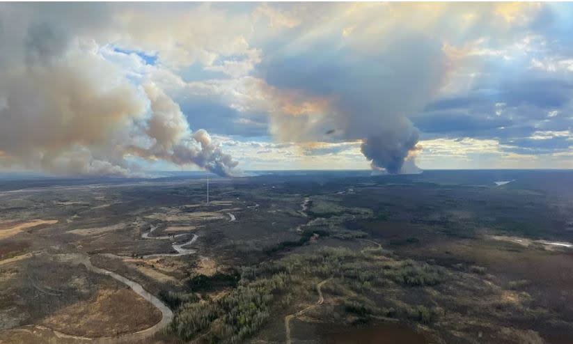
A wildfire threatening the community has now consumed more than 9,600 hectares as shifting winds and rising temperatures continue to accelerate its growth and push the flames closer to the municipality.
Local state of emergency
With the northeastern Alberta community under threat, the municipality has declared a state of local emergency. The community is no stranger to the devastation that wildfire can cause, and officials are urging residents to remain calm but prepared.
Josee St-Onge, a spokesperson with Alberta Wildfire, said the fire has grown since it was last measured and has continued to advance toward the community.
The fire is now around 8 kilometres from the landfill on the southern outskirts of Fort McMurray, she said. The scale and intensity of the fire has made it difficult to track and to manage.
"We're seeing extreme fire behaviour. Smoke columns are developing and the skies are covered in smoke. Firefighters have been pulled from the fire line for safety reasons," St-Onge said.
Winds are blowing from the southwest, gusting up to 40 kilometres per hour. The fire will continue to grow toward the community until those winds shift, she said
"Unfortunately, these are not favourable winds for us and the fire will continue to advance towards the town until we see a wind shift," she said.
"We understand that this is a very stressful time for the community. I want to assure everyone that we are doing everything we can."
Weather fuelling fire
Parched, hot weather continues to fuel extreme, high-intensity conditions across northern Alberta. As of Tuesday morning, more than 50 wildfires were burning across the province including two out-of-control fires: the one encroaching on the Regional Municipality of Wood Buffalo and another threatening homes in County of Grande Prairie.
The wildfire burning out of control southwest of Fort McMurray now covers an estimated 9,602 hectares, growing from 6,579 hectares the previous day. A new aerial scan of the fire, released Tuesday, detailed how the fire had grown toward the west and northwest.
The closest point of the fire is now about 13.5 km from the municipal landfill, the agency said. The landfill is about 3 km from the southern boundary of Fort McMurray.
The wildfire is about 13 km from the intersection of highways 63 and 881, the only two highways that lead south out of the community.
Alberta Wildfire said the wildfire grew Monday when the sun came out and the humidity dissipated during the afternoon. Shifting winds also contributed to the growth "in multiple directions," the agency said
Thick black smoke can be seen on the south side of the Athabasca River in this photo taken from Fort McMurray's Thickwood trail. An evacuation order was issued Tuesday by Regional Municipality of Wood Buffalo for four Fort McMurray neighbourhoods. (Cynthia O’Donnell)
The wind is expected to remain a challenge. On Tuesday winds are expected to blow from the west-southwest at 20 km/h, gusting to 35 km/h, with a high of 21 C.
Josee St-Onge, a spokesperson with Alberta Wildfire, said crews will be working against the weather again Tuesday as unfavourable winds push the fire toward the community.
"It's not what we want to see but we will do everything we can do stop the progression of this wildfire."
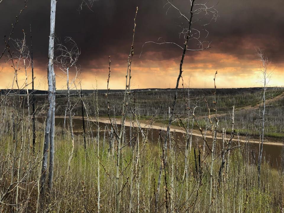
Columns of smoke
Blackened columns of smoke rising from the fire were visible over the community Monday evening. The air remains thick with ash Tuesday and residents have been warned that local air quality remains extremely poor.
In an update to residents, municipal officials said the location of the fire was to blame.
The fire has reached areas burned in 2016 when a wildfire swept through the community, triggering the largest evacuation in Alberta in history. The flames are creating a large amount of smoke as they move through these burn zones, the municipality said.
Emergency officials are hopeful that areas burned by the 2016 wildfire will act as a natural fire break, helping to protect the community from being devastated by fire twice. But there is also concern that strong winds could counteract that effect.
Officials will be watching closely Tuesday to see how the fire behaves in the areas that were scorched seven years ago.
"Generally, when a wildfire hits an area that has already burned, there is less fuel available and it slows down," St-Onge said.
"Today will be a good indication if that old burn will be able to help us.
"
Crews will continue working on a containment line Tuesday. Heavy equipment crews are also working on a fire guard to the southwest of Fort McMurray and on the northern edge of the fire.
Helicopters and airtankers will be dropping water on the active edges of the fire. There are 70 firefighters and 14 helicopters currently assigned to the wildfire.
"This will be a challenging day for firefighters," Alberta Wildfire cautioned.
In parts of the County of Grande Prairie, in northwestern Alberta, residents remain out of their homes. A wildfire near the hamlet of Teepee Creek is now 1,382 hectares and continues to burn out of control.
Alberta Wildfire said firefighters experienced challenging fire behaviour on Monday with high winds, and no precipitation in the forecast.
Alberta Wildfire said the fire was very active Monday with visible smoke columns and flames but crews were able to hold the line. The flames did not spread beyond the fire's existing perimeter, officials said in an update to residents on Tuesday.
Hot spots on the fire are contributing to smoky conditions in the region, the municipality said.
Crews have reinforced the north side of the perimeter and the night vision helicopters worked through the night on the west and east of the fire, making sure embers were contained.
Additional firefighting crews are expected to arrive in the community Tuesday.

