Wet weather to surge across midwestern, northeastern US by late week
Following mainly dry weather early this week, damp conditions will make a comeback in the Ohio Valley, Great Lakes and Northeast as May ends and June begins.
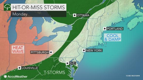
People in the Northeast should not be worried that Sunday's downpours which caused devastating flooding around Ellicott City, Maryland, will occur again on Memorial Day and washout holiday activities.
While spotty showers and thunderstorms may ignite across the Appalachians on Monday afternoon and spread southeastward into the evening hours, most locations will be rain-free for the holiday.
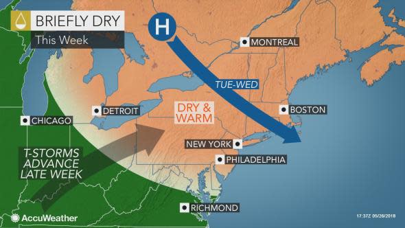
Tranquil weather will hold into Tuesday as people get back to their daily routines, but wet weather will be quickly advancing from the south.
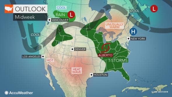
"Tropical moisture is expected to surge up to the Tennessee Valley, bringing frequent rain and soaking thunderstorms to the Ohio Valley and Great Lakes region by Wednesday," AccuWeather Meteorologist Faith Eherts said.
The surge of wet weather will come at the hands of Alberto, which will be pulled northward after unleashing significant rainfall in the Southeast.
While Alberto will be in a weakened state by the time it reaches the Ohio Valley and Great Lakes around midweek, the storm will still have the potential to unleash several inches of rainfall.
"Where the heaviest rainfall sets up, some locations could see flooding issues, especially in low-lying and poor drainage areas," Eherts said.
At this time, the corridor of heaviest rain looks to set up between Interstate 55 in Illinois and I-69 in Indiana. However, any slight shift in the track of Alberto to the west or east will also shift the swath of downpours accordingly.
Chicago may lie in the path of torrential downpours at midweek and commuters into and out of the city should be prepared to face delays.
"Major League Baseball games could be impacted by the wet weather, including games scheduled to take place in Detroit and perhaps Cleveland and Pittsburgh on Wednesday," Eherts said.
Fans heading to the Beltway Series between the Washington Nationals and Baltimore Orioles in Baltimore on Wednesday evening may also have to dodge a spotty shower or thunderstorm.
While the Northeastern states will miss the brunt of Alberto's moisture, which will eventually get swept up into southeastern Canada, there will be a marked increase in showers and storms from late Wednesday to Friday as moist air flows in from the south.
The hit-or-miss downpours may have some residents altering or shortening their plans to golf, fish, head to the swimming pool or go to the beach.
A few of the communities where umbrellas may be needed multiple times during the mid- to late week include Detroit; Cleveland; Pittsburgh, Erie and Philadelphia, Pennsylvania; Buffalo and Syracuse, New York; Baltimore; and Washington, D.C.
The downpours may temporarily slow motorists on sections on interstates 70, 80, 81, 90 and 95.
Some of the storms could unleash several inches of rain in a short amount of time. In areas of the mid-Atlantic that have received an excess of rainfall in recent weeks, flooding will be possible.
People living near small streams or in low-lying areas will be particularly susceptible to water rises.
Dry air will be stubborn to give way farther north, with New England set to experience pleasant weather for much of the week.
Wet weather may not arrive in Boston and Portland, Maine, until the end of the week.
