Wet holiday weekend ahead for the Bay Area
SAN FRANCISCO (KRON) — The Bay Area is in store for a wet holiday weekend as back-to-back storm systems move into the region, according to the National Weather Service. Rain will arrive late Friday with light to moderate, and occasionally heavy rain during the day Saturday.
Sunday’s system will bring more rain along with wind to the region, the NWS said. The system arriving Sunday could last into next week and could potentially bring weather-related hazards, according to KRON4 Meteorologist Kyla Grogan.
“Our next wave of rain is coming in late Friday night and will roll through our Saturday,” said Grogan. “But it is the second round of rain arriving Sunday night and lasting through Tuesday that has me the most concerned.”
Impacts from this weekend’s rain could include rises in creeks, streams and rivers, shallow landslides, and ponding of water on roadways, the NWS warned.
“The reason is that, not only is it a more robust round of rain, but it also will be coming down on top of already saturated soil,” said Grogan. “That means that flooding will be a concern across the Bay Area and particularly in the North Bay, where many of our creeks and streams will be rising.”
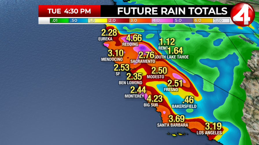
The highest rain totals are expected in the North Bay and coastal ranges, the NWS said, where 1 to 3 inches of rain could fall.
Winter weather advisory issued
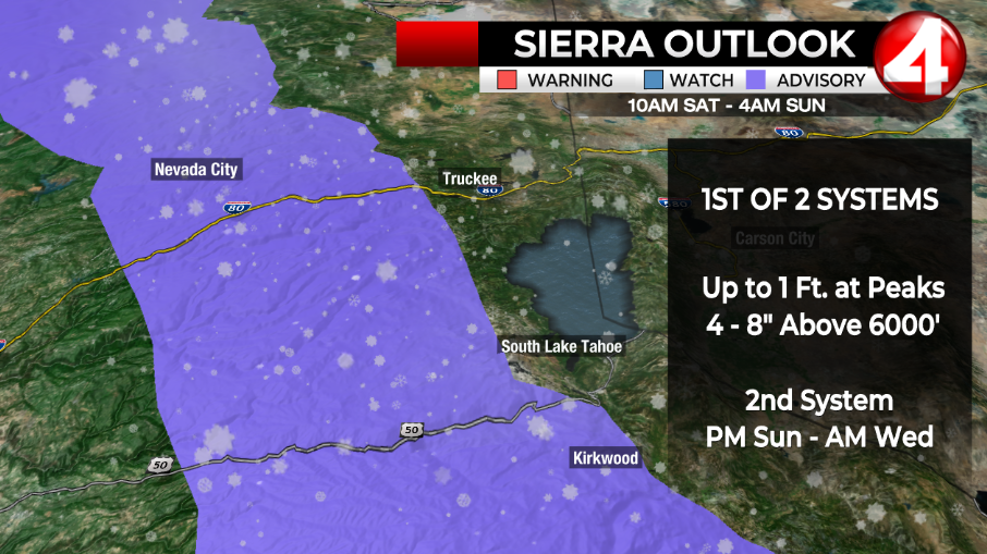
The heavy rain in the Bay Area will lead to another round of snowfall in the Sierra. A winter weather advisory has been issued from 10 a.m. Saturday though 4 a.m. Sunday, according to the NWS. There is also a winter storm watch in effect from Sunday evening through Wednesday morning.
Four to 8 inches of snow are possible on Saturday with up to a foot possible near the peaks. The heaviest snowfall is predicted for Saturday night, according to the NWS.
This weekend’s snow could have significant impacts on those traveling for the holiday weekend, with the NWS warning of snow-covered roads, slippery roads, reduced visibility and travel delays. Chain controls are possible, the NWS said.
“In addition to the rain expected there will be two shots of Sierra snow beginning this Saturday,” said Grogan. “The first storm is more modest than the second. When it’s all said and done, I expect we will see a few feet of new snow up at the peaks in and around Tahoe.”
“That is really good news as we are still running well below average for our snowpack this year. This weather pattern will be a chance for California to catch up a bit,” Grogan added.
For the latest news, weather, sports, and streaming video, head to KRON4.

