Wet and cool pattern sets up for the Prairies, eyes on some late-week snow
It wouldn't be Canada's unofficial kick off to summer without signs of snow looming for the May long weekend forecast. All eyes are on the setup for this week, one that shows rounds of rain and cooler temperatures, which could result in some significant alpine snow.
DON'T MISS: Canada's May long weekend has it all, except for the 'perfect' forecast
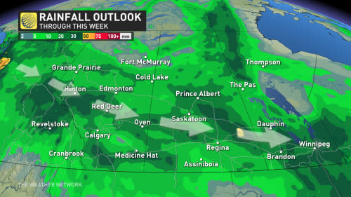
A trough and incoming Pacific lows will now track across Western Canada for the next several days, bringing in periods of widespread rain.
All of this rainfall is certainly good news for the region's long-running drought, especially as we inch closer to the heart of wildfire season. The downfall, however, is that most of the heaviest accumulations will stay south of the Fort McMurray area and the far north, areas where it is most needed for wildfires.
SEE ALSO: Fort McMurray wildfire threat prompts evacuation alert
Wildfire smoke has already been causing poor air quality for parts of the region, and special air quality statements are in place in northern Alberta, and central areas of Saskatchewan and Manitoba.
Remember to limit time outdoors when air quality is poor, as it can have adverse effects on health -- especially for young children and elderly people.
Wet and cooler pattern takes shape for this week
A couple of low-pressure systems will bring periods of widespread rain to the region this week, especially near the Yellowhead across Alberta and Saskatchewan.
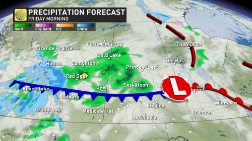
The first system will impact the region Wednesday through Thursday, with the second occurring Thursday through Saturday. The latter will bring more widespread, heavier rain, including to many of the long-term drought areas.
This wet pattern will bring beneficial rain to central Alberta, though missing desperate areas of the north, once again. The rain is highly beneficial to agriculture, but could also become an issue with delaying spring planting.
Signs of snow as temperatures drop
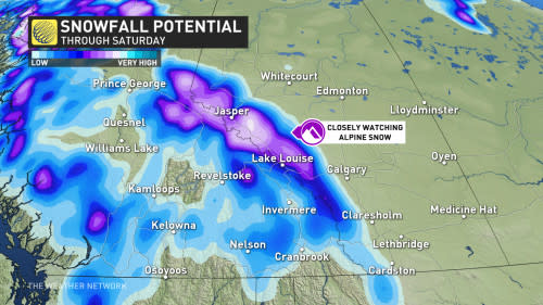
In addition to the rain, Thursday’s system could bring alpine snow to the Rockies as temperatures sit about 5-10 degrees below normal in Alberta and Saskatchewan.
We will closely watch to see if any snow will reach into the foothills and even localized areas east of the Rockies through the start of the May long weekend.
DON’T MISS: What La Niña could mean for Canada’s upcoming summer
Temperatures will be well below seasonal across most of the region for the long weekend, with another significant system possible early next week.
Stay with The Weather Network for all the latest on your forecast across the Prairies.

