Weather alert: Ohio at 'significant' risk for tornadoes, severe storms Tuesday
This is the latest weather update as of Tuesday, April 2, 2024.
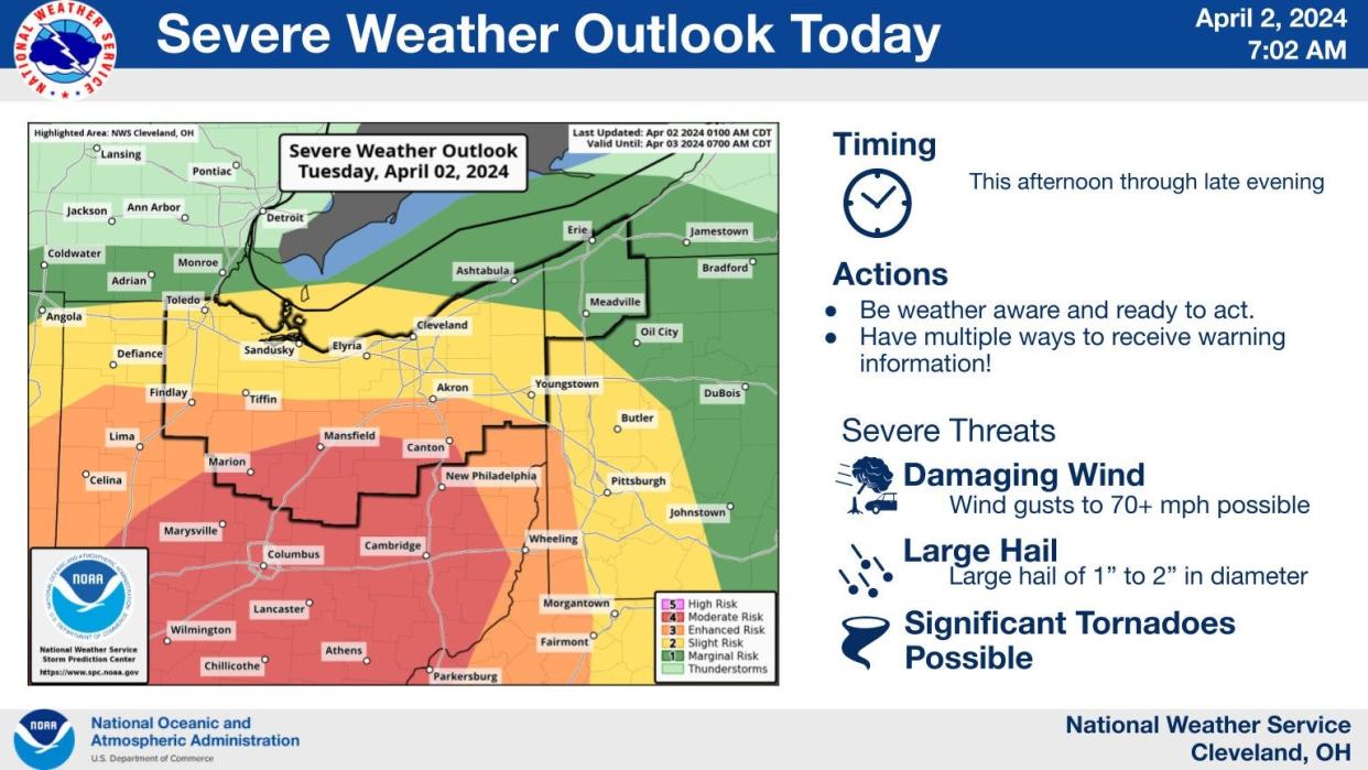
A wet and stormy Tuesday is expected across Northeast Ohio.
The National Weather Service said the region is under the risk Tuesday for severe storms and even some tornadoes.
Most of northern Ohio including most of Medina, Summit and Portage counties are at a "slight" risk for severe weather.
Parts of southern Medina and Summit counties including Akron and northern Stark and Wayne counties are at enhanced risk for strong storms.
Southern Wayne county along with Mansfield and south of Canton are at a "moderate" risk for severe weather.
"Plan ahead now for strong wind gusts, large hail and the possibility of tornadoes across much of the area," the weather service said.
Flood warning in northern Summit County as Cuyahoga River likely to spill over in CVNP
Waves of rain and storms are expected across the region throughout the day.
The weather service said the greatest risk for severe storms will be Tuesday afternoon into the evening.
The biggest threat is for damaging wind gusts up to 70 miles per hour, hail of 1 to 2 inches in diameter along with "significant" risk of tornadoes possible.
"Several tornadoes, some strong or intense, will be possible," the weather service said.
The storms could bring significant rainfall, too, that could cause minor flooding along rivers and creeks.
Things will cool down after Wednesday with a chance of snow showers through Friday.
What's the eclipse weather forecast for Akron and Canton?
The weather in Northeast Ohio can be fickle and change by the minute, especially in early April.
The weekend forecast for Saturday and Sunday leading up to the big day look clear with sunny skies and highs in the 50s.
The eclipse day forecast is looking decent.
Accuweather is predicting highs in the middle 60s with partly cloudy skies in Akron and Canton on April 8 with a 37% chance of cloud cover in the afternoon.
The National Weather Service forecast is similar.
The forecast by the weather service calls for a chance of showers with partly sunny skies and a high near 62 on Monday.
What's the forecast?
Tuesday: Showers and possibly a thunderstorm, mainly before 1 p.m., then a chance of showers and thunderstorms after 1 p.m. High near 65. East wind 7 to 10 mph becoming south in the afternoon. Chance of precipitation is 100%. New rainfall amounts between a quarter and half of an inch possible.
Tuesday night: Showers and thunderstorms before 11 p.m., then showers likely and possibly a thunderstorm between 11 p.m. and midnight, then a chance of showers and thunderstorms after midnight. Low around 47. Southwest wind around 14 mph. Chance of precipitation is 80%. New rainfall amounts between a quarter and half of an inch possible.
Wednesday: Showers likely and possibly a thunderstorm. Mostly cloudy, with a high near 51. Southwest wind 11 to 14 mph. Chance of precipitation is 60%. New precipitation amounts of less than a tenth of an inch, except higher amounts possible in thunderstorms.
Wednesday night: Rain showers likely before 2 a.m., then rain and snow showers. Low around 35. Southwest wind around 6 mph. Chance of precipitation is 80%. Little or no snow accumulation expected.
Thursday: Rain and snow showers, becoming all rain after 11 a.m. High near 45. West wind 6 to 10 mph becoming northwest in the afternoon. Chance of precipitation is 100%. Little or no snow accumulation expected.
Thursday night: Rain and snow showers likely before 5am, then a chance of snow showers. Cloudy, with a low around 31. Chance of precipitation is 60%. New snow accumulation of less than a half inch possible.
Friday: Snow showers before 2 p.m., then a chance of rain and snow showers. High near 42. Chance of precipitation is 80%.
Friday night: A chance of rain and snow showers before 8 p.m. Mostly cloudy, with a low around 33. Chance of precipitation is 30%.
Saturday: Mostly cloudy, with a high near 47.
Saturday night: Mostly cloudy, with a low around 31.
Sunday: Mostly sunny, with a high near 55.
Sunday night: Partly cloudy, with a low around 37.
Monday: A chance of showers. Partly sunny, with a high near 62. Chance of precipitation is 30%.
Check Akron weather hourly
Need to know weather conditions by the hour? Make sure to check out our weather page here.
This article originally appeared on Akron Beacon Journal: Northern Ohio at 'significant' risk for tornadoes, storms on Tuesday

