Large Hail Damages Parts of Northern Mexico

DOTHAN, Ala. (WDHN) — Severe weather brought damaging winds, hail and tornadoes to the South-Central United States, but we were not the only country that felt the effect’s of Friday’s storm system.
Just over the border, the same system brought larger-than-baseball-sized hail to parts of Mexico.
The hailstorm happened in Sabinas, Mexico, about 100 mile west-northwest of Laredo, Texas on Friday afternoon. It is in Mexico’s Coahuila state.
Video and photos on social media show baseball-sized hail smashing into cars and shattering windshields.
Video de la granizada severa sobre Sabinas Coahuila en la región Carbonífera, durante esta tarde. pic.twitter.com/MjvdgMc7K2
— Yassin Lerma (@Lic_yassinlerma) March 16, 2024
More from the massive hail storm in the north-eastern part of Coahuila in Mexico yesterday. BRUTAL! 👀pic.twitter.com/Wx4TT7bUXZ
— Volcaholic 🌋 (@volcaholic1) March 16, 2024
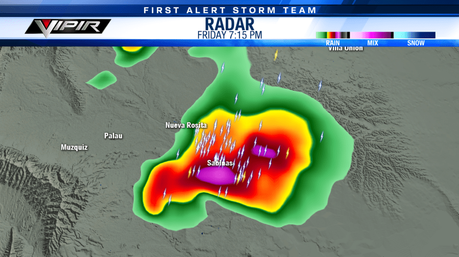
Radar imagery from the time of the storm shows high reflectivity values, which can be indicative of either torrential rainfall or heavy hail. Note that all times are in Central Time. Sabinas is one hour behind.
When values are higher than 60 dbz, that’s when hail is more likely. Storm values taken from Baron’s system depict measures between 63 and 68 dbz.
In their Friday afternoon update, the Storm Prediction Center wrote that parts of Southwest Texas would be at risk of severe thunderstorms capable of damaging winds and large hail. Portions of Mexico near the border were in a similarly favorable environment.
Strong heating occurred near the surface ahead of an approaching cold front, and temperatures rapidly decreased with height. With abundant cloud layers below freezing and strong updrafts (forcing), hail became more likely.
Supercells formed in Mexico during the late afternoon and early evening hours.
For the latest news, weather, sports, and streaming video, head to WDHN - wdhn.com.

